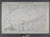
Maps of Richmond County
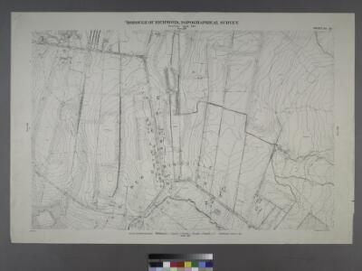
Borough of Richmond, Topographical Survey.
from Borough of Richmond, Topographical Survey.
Sheet No. 53. [Includes Richmond Hill Road, Forest Hill Road, Old Stone Road and Mill Road.]; Borough of Richmond, Topographical Survey.
from Borough of Richmond, Topographical Survey. Staten Island. Topographical Bureau.,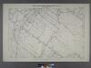
Sheet No. 45. [Includes New Springville, Bridge Avenue, Old Stone Road and Richmond Road.]; Borough of Richmond, Topographical Survey.
from Borough of Richmond, Topographical Survey. Staten Island. Topographical Bureau.,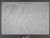
Sheet No. 44. [Includes Linoleumville (Travis), (New Springville), Main Creek and Springville Creek]; Borough of Richmond, Topographical Survey.
from Borough of Richmond, Topographical Survey. Staten Island. Topographical Bureau.,
26B - N.Y. City (Aerial Set).
from Sectional aerial maps of the City of New York / [photographed and assembled under the direction of the chief engineer, July 1st, 1924].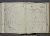
Part of Ward 3. [Map bound by Richmond Turnpike, Darcys Lane, Willow Brook Road (Gun Factory RD), Bradley Ave, Manor Road (Egbert Road), Rockland RD, Forest Hill Road (Port Richmond RD), Hotel Ave]
from Atlas of the city of New York, borough of Richmond, Staten Island. From actual surveys and original plans, by George W. and Walter S. Bromley.
Section 11.
from Atlas of Staten Island, Richmond County, New York, from official records and surveys; compiled and drawn by F. W. Beers.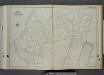
Part of Ward 3. [Map bound by Richmond Creek, Fresh Kills, Springville Flaak, Springville Creek, Travis Ave (Union), Richmond Ave (Bridge Ave) (Old Stone RD), Rockland Ave, Klondike Ave, Richmond Hill Road, Alaska PL, Yukon PL, Meadow Lane, M
from Atlas of the city of New York, borough of Richmond, Staten Island. From actual surveys and original plans, by George W. and Walter S. Bromley.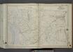
Part of Ward 3. [Map bound by River Road (Water St), Chelsea Road, Bloomfield Ave (Decker Ave), Hughes Ave, Merrill Ave, Richmond Ave, Travis Ave (Union Ave), Fresh Kills, Richmond Turnpike, Cannon Ave (Lexington), Chelsea Creek, Arthur
from Atlas of the city of New York, borough of Richmond, Staten Island. From actual surveys and original plans, by George W. and Walter S. Bromley.
Part of Northfield.
from Atlas of Staten Island, Richmond County, New York, from official records and surveys; compiled and drawn by F. W. Beers.
Part of Northfield & Middletown.
from Atlas of Staten Island, Richmond County, New York, from official records and surveys; compiled and drawn by F. W. Beers.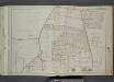
Part of Wards 1, 2 & 3. [Map bound by Forest Hill Road (Fort Richmond), Willow Brook Road (Gun Factory RD), Caswell Ave, Harvey Ave, Marble St, Byrne Ave, Buchanan Ave, Delmont St, Cedar Ave, Washington Ave, Broadway]
from Atlas of the city of New York, borough of Richmond, Staten Island. From actual surveys and original plans, by George W. and Walter S. Bromley.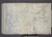
Part of Wards 2 & 3. [Map bound by Old Place Creek, Washington Ave, Lisk Ave, Lamberts Lane, Merrill Ave, Richmond Road, Richmond Turnpike, Willow Brook Road, New Road, Jones or Rockland Ave, Old Shore Road, Union Ave, Lexington Ave, Cannon Av
from Atlas of the borough of Richmond, city of New York.
Area District Map Section No. 26
from Area district map / City of New York, Board of Estimate and Apportionment.
Height District Map Section No. 26; Height district map / City of New York, Board of Estimate and Apportionment.
from Height district map / City of New York, Board of Estimate and Apportionment. New York (N.Y.). Board of Estimate and Apportionment,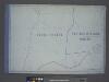
Use District Map Section No. 26; Use district map / City of New York, Board of Estimate and Apportionment.
from Use district map / City of New York, Board of Estimate and Apportionment. New York (N.Y.). Board of Estimate and Apportionment,
General map of the borough of Richmond (Staten Island) in the city of New York : showing in addition to the existing topographical features of the borough a tentative and preliminary plan for a street system of the same.
from Staten Island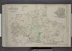
Part of Wards 2, 3, & 4. [Map bound by Forest Hill Road, New Road, Willow Brook Road, Manor Road, Ocean Terrace, Richmond Road, Amboy Road, Fresh Kills Road, Richmond Hill Road; Sub Plan - Summit Ave, Beacon Ave, Grand Ave, Walden PL, Pleasant
from Atlas of the borough of Richmond, city of New York.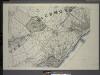
General map of the borough of Richmond (Staten Island) in the city of New York : showing in addition to the existing topographical features of the borough a tentative and preliminary plan for a street system of the same.
from Staten Island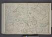
Part of Wards 3, 4, & 5. [Map bound by Cannon Ave, Burying Hill Road, Richmond Turnpike, Union Ave, Old Stone Road, Rockland Ave, Forest Hill Road, Fresh Kills Road, State Line; Lots at Linoleumville - Richmond Turnpike, Feldmeyer Lane]
from Atlas of the borough of Richmond, city of New York.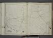
Part of Ward 3. [Map bound by Forest Hill Road (Old Mill Road), Richmond Hill Road, Klondike Ave, Rockland Ave (Saw Mill RD), Richmond Creek, Old Hill Road, Alaska PL]
from Atlas of the city of New York, borough of Richmond, Staten Island. From actual surveys and original plans, by George W. and Walter S. Bromley.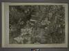
20D - N.Y. City (Aerial Set).
from Sectional aerial maps of the City of New York / [photographed and assembled under the direction of the chief engineer, July 1st, 1924].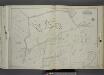
Part of Wards 2 & 3. [Map bound by Rockland Ave (Saw Mill RD), Bradley Ave (Manor RD), Washington St, Livingston Ave, Willow Brook Road (Manor RD), Manor Road, Cliffwood Ave, Todt Hill Road, Vanderbilt Pilot - Moravian Cemetery, Meisner Ave]
from Atlas of the city of New York, borough of Richmond, Staten Island. From actual surveys and original plans, by George W. and Walter S. Bromley.
26A - N.Y. City (Aerial Set).
from Sectional aerial maps of the City of New York / [photographed and assembled under the direction of the chief engineer, July 1st, 1924].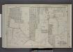
Part of Wards 2 & 3. [Map bound by Richmond Turnpike, Chestnut Ave, Todt Hill Road, Ocean Terrace, Manor Road, Egbert Ave, New Road, Willow Brook Road, Woodward Ave]
from Atlas of the borough of Richmond, city of New York.
Section 14.
from Atlas of Staten Island, Richmond County, New York, from official records and surveys; compiled and drawn by F. W. Beers.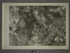
27A - N.Y. City (Aerial Set).
from Sectional aerial maps of the City of New York / [photographed and assembled under the direction of the chief engineer, July 1st, 1924].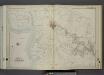
Part of Ward 3. [Map bound by Little Fresh Kills, Richmond Turnpike, Burying Hill Road, Cannon Ave (Lexington Ave), Burke Ave, Linoleum Ave (Penn Ave), Decker Ave, Watson Ave, Pearson St (Liberty Ave), Wild Ave, Fort Creek, Fresh Kills]
from Atlas of the city of New York, borough of Richmond, Staten Island. From actual surveys and original plans, by George W. and Walter S. Bromley.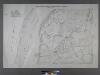
Sheet No. 43. [Includes Wild Avenue, Linoleumville (Travis).]; Borough of Richmond, Topographical Survey.
from Borough of Richmond, Topographical Survey. Staten Island. Topographical Bureau.,