Maps of Richmond County
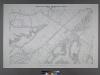
Sheet No. 36. [Includes Chelsea Avenue, Union Avenue, Chelsea Creek, Richmond Turnpike and (Travis) Linoleum Ville.]; Borough of Richmond, Topographical Survey.
from Borough of Richmond, Topographical Survey. Staten Island. Topographical Bureau.,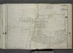
Part of Ward 3. [Map bound by Attorney St, Essex St, Lambert St, Center St, Spring St, De Puy St (Columbia Ave), Richmond Ave (Old Stone Road), Deppe PL, Morris St, Franklin St, Houston St, Watchogue Road, Willow Brook Road (Gun Factory RD),
from Atlas of the city of New York, borough of Richmond, Staten Island. From actual surveys and original plans, by George W. and Walter S. Bromley.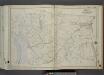
Part of Ward 3. [Map bound by River Road (Water St), Chelsea Road, Bloomfield Ave (Decker Ave), Hughes Ave, Merrill Ave, Richmond Ave, Travis Ave (Union Ave), Fresh Kills, Richmond Turnpike, Cannon Ave (Lexington), Chelsea Creek, Arthur
from Atlas of the city of New York, borough of Richmond, Staten Island. From actual surveys and original plans, by George W. and Walter S. Bromley.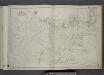
Part of Ward 3. [Map bound by Sedge Pond, Old Place Creek, Western Ave, Washington Ave, John St, Northfield Ave (Franklin Ave), South Ave, Harbor RD, Brabant St (Beech), Union Ave, Lisk Ave, Henry St, East Broadway, Canal St, Gauldy Ave, Her
from Atlas of the city of New York, borough of Richmond, Staten Island. From actual surveys and original plans, by George W. and Walter S. Bromley.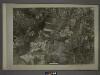
20D - N.Y. City (Aerial Set).
from Sectional aerial maps of the City of New York / [photographed and assembled under the direction of the chief engineer, July 1st, 1924].
Section 5
from Atlas of Staten Island, Richmond County, New York, from official records and surveys; compiled and drawn by F. W. Beers.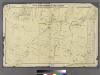
Part of Northfield & Castleton.
from Atlas of Staten Island, Richmond County, New York, from official records and surveys; compiled and drawn by F. W. Beers.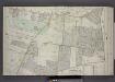
Part of Wards 1 & 3. [Map bound by Washington Ave, Richmond Road, Decker Ave, Barrett Ave, Cherry Lane, Jewett Ave, Richmond Turnpike, Neptune PL, Richmond Road, Merrill Ave, Lamberts Lane]
from Atlas of the borough of Richmond, city of New York.
Part of Northfield.
from Atlas of Staten Island, Richmond County, New York, from official records and surveys; compiled and drawn by F. W. Beers.
Section 11.
from Atlas of Staten Island, Richmond County, New York, from official records and surveys; compiled and drawn by F. W. Beers.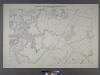
Sheet No. 28. [Includes Bloomfield, (Staten Island Wet Lands Preserve), (Bulls Head) and South Avenue.]; Borough of Richmond, Topographical Survey.
from Borough of Richmond, Topographical Survey. Staten Island. Topographical Bureau.,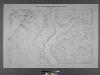
Sheet No. 44. [Includes Linoleumville (Travis), (New Springville), Main Creek and Springville Creek]; Borough of Richmond, Topographical Survey.
from Borough of Richmond, Topographical Survey. Staten Island. Topographical Bureau.,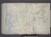
Part of Wards 2 & 3. [Map bound by Old Place Creek, Washington Ave, Lisk Ave, Lamberts Lane, Merrill Ave, Richmond Road, Richmond Turnpike, Willow Brook Road, New Road, Jones or Rockland Ave, Old Shore Road, Union Ave, Lexington Ave, Cannon Av
from Atlas of the borough of Richmond, city of New York.
Area District Map Section No. 20; Area district map / City of New York, Board of Estimate and Apportionment.
from Area district map / City of New York, Board of Estimate and Apportionment. New York (N.Y.). Board of Estimate and Apportionment,
Height District Map Section No. 20; Height district map / City of New York, Board of Estimate and Apportionment.
from Height district map / City of New York, Board of Estimate and Apportionment. New York (N.Y.). Board of Estimate and Apportionment,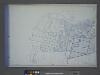
Use District Map Section No. 20; Use district map / City of New York, Board of Estimate and Apportionment.
from Use district map / City of New York, Board of Estimate and Apportionment. New York (N.Y.). Board of Estimate and Apportionment,
General map of the borough of Richmond (Staten Island) in the city of New York : showing in addition to the existing topographical features of the borough a tentative and preliminary plan for a street system of the same.
from Staten Island
Map of the Village of New Brighton, Richmond Co., New York City, NY.
From Staten Island
Arthur Kill
1 : 24000
Arthur Kill
1 : 24000
Arthur Kill
1 : 24000
Arthur Kill
1 : 24000
Arthur Kill
1 : 24000
Arthur Kill
1 : 24000
Arthur Kill
1 : 24000
Map of Staten Island o Richmond County. 16 views of buildings on border. Also view of Elliottville the property of Dr. S. M. Elliott.
From Staten Island
Staten Island South.
1 : 253440 Dripps, Matthew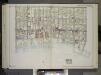
Brooklyn, Vol. 2, Double Page Plate No. 27; Part of Wards 30 & 31, Section 19; [Map bounded by 86th St., 23rd Ave., 24th Ave.; Including Gravesend Bay, 17th Ave.] / by and under the direction of Hugo Ullitz.
From Volume 2.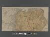
New Standard Map of the Borough of Richmond.
From Staten Island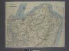
![Sheet No. 36. [Includes Chelsea Avenue, Union Avenue, Chelsea Creek, Richmond Turnpike and (Travis) Linoleum Ville.]; Borough of Richmond, Topographical Survey.](https://images-2.georeferencer.com/images/iiif/819817188141/full/,300/0/native.jpg)

