Maps of Richmond County
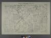
Sheet No. 31. [Includes Castleton Corners and Todt Hill.]; Borough of Richmond, Topographical Survey.
from Borough of Richmond, Topographical Survey. Staten Island. Topographical Bureau.,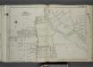
Part of Ward 1. [Map bound by Egbert Ave, Brookside Ave, Forest Ave, Clove Road, Purcell St, Raleigh Ave (Division Ave), Broadway, 1st St, Bement Ave, Britton Ave, Slosson Ave, Fairview Ave, Potter Ave, Manor Road, Marlboro PL, Palmer Ave, Wina
from Atlas of the city of New York, borough of Richmond, Staten Island. From actual surveys and original plans, by George W. and Walter S. Bromley.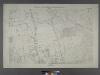
Borough of Richmond, Topographical Survey.
from Borough of Richmond, Topographical Survey.
Borough of Richmond, Topographical Survey.
from Borough of Richmond, Topographical Survey.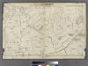
Section 7.
from Atlas of Staten Island, Richmond County, New York, from official records and surveys; compiled and drawn by F. W. Beers.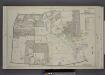
Part of Ward 1. [Map bound by Cherry Lane, Forest Ave, Lowell Ave, Davis Ave, Pelton Ave, Bard Ave, Glove Road, Richmond Turnpike, Jewett Ave]
from Atlas of the borough of Richmond, city of New York.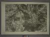
21C - N.Y. City (Aerial Set).
from Sectional aerial maps of the City of New York / [photographed and assembled under the direction of the chief engineer, July 1st, 1924].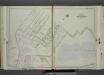
Part of Ward 1. [Map bound by Bement Ave, Harvest Ave, Revere Ave (Laurel Ave), University PL, Greenwood Ave, Forest Ave (Barrett Blvd), Reservoir North Basin, Richmond Turnpike, Clove Road]
from Atlas of the city of New York, borough of Richmond, Staten Island. From actual surveys and original plans, by George W. and Walter S. Bromley.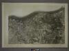
21A - N.Y. City (Aerial Set).
from Sectional aerial maps of the City of New York / [photographed and assembled under the direction of the chief engineer, July 1st, 1924].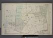
Part of Wards 1 & 2. [Map bound by Grymes Hill, Howard Ave, Woodside Ave, Centre Ave, Irving PL, Vanderbilt Ave, Richmond Road, Clove Road, Clove PL, Lakewood RD, Richmond Turnpike]
from Atlas of the borough of Richmond, city of New York.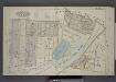
Part of Wards 1 & 2. [Map bound by Forest Ave, Brighton Ave, Castleton Ave, Woodstock St, Richmond Turnpike, Eddy St, Howard Ave, Silver Lake Park, Clove PL, Bard PL, Bard Ave, Lowell Ave]
from Atlas of the borough of Richmond, city of New York.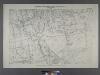
Sheet No. 16. [Includes West New Brighton (West Brighton) and (Port Richmond).]
from Borough of Richmond, Topographical Survey.
West New Brighton.
from Atlas of Staten Island, Richmond County, New York, from official records and surveys; compiled and drawn by F. W. Beers.
Borough of Richmond, Topographical Survey.
from Borough of Richmond, Topographical Survey.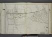
Part of Wards 1 & 2. [Map bound by Dongan Ave, Fairview Ave, Knox PL (1st St), Slosson Ave, Richmond Turnpike, Clove Road, Schoharie St, Cayuga St, Oswego St, Saratoga Ave, Little Clove Road, Ocean Terrace, Chestnut Ave, Todt Hill Ro
from Atlas of the city of New York, borough of Richmond, Staten Island. From actual surveys and original plans, by George W. and Walter S. Bromley.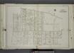
Part of Ward 1. [Map bound by Castleton Ave, Forest Ave (Brighton), Greenwood Ave, University PL, Revere Ave (Laurel Ave), Laurel Ave, Bard Ave, Lawrence Ave (Pelton Ave), Davis Ave, Pelton Ave (Lowell Ave), Shaw Ave, Bement Ave, Cary Ave]
from Atlas of the city of New York, borough of Richmond, Staten Island. From actual surveys and original plans, by George W. and Walter S. Bromley.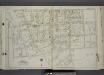
Part of Ward 1. [Map bound by Castleton Ave, N. Burgher Ave (Burgher), Cary Ave, Bement Ave, John T. Barrett Hrs., Broadway, Raleigh (Division Ave) Ave, Freeman PL, Purcell St, Clove Road (Brooks Ave) (Columbia St), Forest Ave (Cherry L
from Atlas of the city of New York, borough of Richmond, Staten Island. From actual surveys and original plans, by George W. and Walter S. Bromley.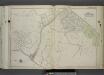
Part of Ward 2. [Map bound by Ocean Terrace, Little Clove Road, Seneca Ave, Schohaire St, Clove Road, Richmond Turnpike, Serpentine Road, Hillside Ave, Cedar Terrace, Northcote Ave, Richmond Road, Douglas Road, Emerson Drive]
from Atlas of the city of New York, borough of Richmond, Staten Island. From actual surveys and original plans, by George W. and Walter S. Bromley.
Staten Island, V. 2, Plate No. 147 [Map bounded by Dongan Ave., Little Clove Rd., Chestnut Ave., Todt Hill Rd., Fairview Ave.]
From Atlas 163.1. Vol. 2, 1917.
Height District Map Section No. 21; Height district map / City of New York, Board of Estimate and Apportionment.
from Height district map / City of New York, Board of Estimate and Apportionment. New York (N.Y.). Board of Estimate and Apportionment,
Area District Map Section No. 21; Area district map / City of New York, Board of Estimate and Apportionment.
from Area district map / City of New York, Board of Estimate and Apportionment. New York (N.Y.). Board of Estimate and Apportionment,
Use District Map Section No. 21; Use district map / City of New York, Board of Estimate and Apportionment.
from Use district map / City of New York, Board of Estimate and Apportionment. New York (N.Y.). Board of Estimate and Apportionment,
General map of the borough of Richmond (Staten Island) in the city of New York : showing in addition to the existing topographical features of the borough a tentative and preliminary plan for a street system of the same.
from Staten Island
Brighton Heights, Clifton, Fort Wadsworth, Fox Hills, Grymes hill, Livingston, New Brighton, Randall Manor, Rosebank, Shore Acres, St. George, Stapleton, Tompkinsville, Ward hill, West New Brighton. (cont.)
From District 2
Map of the Village of New Brighton, Richmond Co., New York City, NY.
From Staten Island
Map of the City of Brooklyn as consolidated by an act of the Legislature of the Ste of New York . . . Constructed from the official maps of the Commissioners . . . Exhibiting the farm lines names of the original owners.
From Brooklyn
Map of Staten Island o Richmond County. 16 views of buildings on border. Also view of Elliottville the property of Dr. S. M. Elliott.
From Staten Island
Staten Island South.
1 : 253440 Dripps, Matthew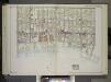
Brooklyn, Vol. 2, Double Page Plate No. 27; Part of Wards 30 & 31, Section 19; [Map bounded by 86th St., 23rd Ave., 24th Ave.; Including Gravesend Bay, 17th Ave.] / by and under the direction of Hugo Ullitz.
From Volume 2.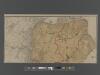
![Sheet No. 31. [Includes Castleton Corners and Todt Hill.]; Borough of Richmond, Topographical Survey.](https://images-2.georeferencer.com/images/iiif/020119495440/full/,300/0/native.jpg)

