Maps of Flanders

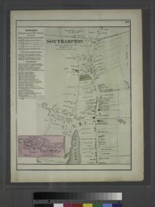
Southampton, Town of Southampton, Suffolk Co. - Flanders, Town of Southampton, Suffolk Co.
from Atlas of Long Island, New York. From recent and actual surveys and records.
Mattituck
1 : 24000
Mattituck
1 : 24000
Mattituck
1 : 24000
Mattituck
1 : 24000
Mattituck
1 : 24000
Riverhead
1 : 62500
Riverhead
1 : 62500
Riverhead
1 : 62500
Riverhead
1 : 62500
Riverhead
1 : 62500
Riverhead
1 : 62500
Riverhead
1 : 62500
Riverhead
1 : 62500
Riverhead
1 : 62500
Riverhead
1 : 62500
Riverhead
1 : 24000
Riverhead
1 : 24000
Riverhead
1 : 24000
Riverhead
1 : 24000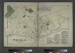
Riverhead, Town of Riverhead, Suffolk Co. - Northville, Town of Riverhead, Suffolk Co.
from Atlas of Long Island, New York. From recent and actual surveys and records.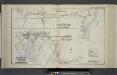
Part of Good Ground and Canoe Place; Eastport Speonk and Part of Remsenburg
from Atlas of ... Suffolk County, Long Island, New York ... : based upon actual measurements by our own corps of engineers, maps on file at county offices, also maps from actual surveys furnished by individual owners / under the supervision of Merritt B. Hyde.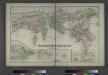
Southold and Shelter Island, Suffolk Co. L.I. - Village, North of Greensport, Town of Southold, Suffolk Co. - Part of Town of Southold.
from Atlas of Long Island, New York. From recent and actual surveys and records.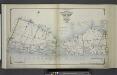
Index Map No. 1 of a part of Suffolk County. South Side - Ocean Shore, Long Island. Southampton. Published by E. Belcher Hyde. 97 Liberty Street, Brooklyn. 5 Beekman Street, Manhattan. 1916. Volume Two.
from Atlas of ... Suffolk County, Long Island, New York ... : based upon actual measurements by our own corps of engineers, maps on file at county offices, also maps from actual surveys furnished by individual owners / under the supervision of Merritt B. Hyde.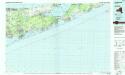
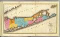
Long Island East
1 : 100000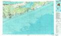
Long Island East
1 : 100000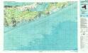
Long Island East
1 : 100000
Map of the county of Westchester / by David H. Burr; engd. by Rawdon, Clark & Co., Albany, & Rawdon, Wright & Co., New York.; An atlas of the state of New York: containing a map of the state and of the several counties / by David H. Burr.
from An atlas of the state of New York : containing a map of the state and of the several counties / by David H. Burr. Burr, David H.; Rawdon, Clark & Co.; Rawdon, Wright & Co.; Stone & Clark Republishers,
Map of the county of Westchester / by David H. Burr; engd. by Rawdon, Clark & Co., Albany, & Rawdon, Wright & Co., New York.; An atlas of the state of New York, designed for the use of engineers, containing a map of the state and of the several counties. / Projected and drawn ... under the superintendence and direction of Simeon de Witt.
from An atlas of the state of New York, designed for the use of engineers, containing a map of the state and of the several counties. / Projected and drawn ... under the superintendence and direction of Simeon de Witt. Burr, David H.; De Witt, Simeon; Rawdon, Clark & Co.; Rawdon, Wright & Co.; Stone & Clark Republishers,