Maps of Hudson County

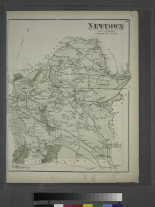
Newtown, Queens Co. L.I.
from Atlas of Long Island, New York. From recent and actual surveys and records.
Map of New York City showing portions of Brooklyn, Jersey City, and Westchester Co.
From Manhattan
Borough of Manhattan [and] the principal portions of the Boroughs of Bronx, Brooklyn, and Queens and the Business District of Jersey City.
From Manhattan
TheHome Life Publishing Co.' s map of the City of New York.
From Manhattan
Map of the five cities of New York, Brooklyn, Jersey City, Hoboken & Hudson City : Northern sheet
Dripps, M. (Matthew) Common Council
Map of the five cities of New York, Brooklyn, Jersey City, Hoboken & Hudson City : Southern sheet
Dripps, M. (Matthew) Common Council
Index: Borough of Manhattan. Scale 1800 feet to the Inch. LEGEND, [Battery Park - 158th Street].
from Atlas of the city of New York, borough of Manhattan. From actual surveys and official plans / by George W. and Walter S. Bromley.
City & county map of New York, Brooklyn, Williamsburgh, Jersey City & the adjacent waters.
From Manhattan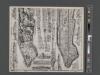
Geologic map and sections of Manhattan Island, State of New York
From Manhattan
Hagstrom ́s map of Manhattan and Bronx
New York City Map. Extracted from Phelps' strangers and citizens' guide to New York City, with maps and engravings.
From Manhattan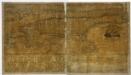
Map of the city and county of New York : with the adjacent country / by David H. Burr.
from Whole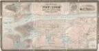
City & county map of New-York, Brooklyn, Williamsburgh, Jersey City & the adjacent waters / by J.H. Colton, N.Y. ; engraved by D.G. Johnson, N. York.
from Manhattan
Map of the city and county of New York : with the adjacent country / by David H. Burr.
from An atlas of the state of New York, designed for the use of engineers, containing a map of the state and of the several counties. / Projected and drawn ... under the superintendence and direction of Simeon de Witt.
Map of the city and county of New York : with the adjacent country / by David H. Burr.
from An atlas of the state of New York : containing a map of the state and of the several counties / by David H. Burr.
Map of the city and county of New York : with the adjacent country / by David H. Burr.
from An atlas of the state of New York : containing a map of the state and of the several counties. / Projected and drawn under the superintendence and direction of Simeon de Witt ... And also the physical geography of the State ...
Map of the Borough of Manhattan, New York City, centering on the campus of Columbia University.
From Manhattan
Map of Newtown Long Island. Designed to exhibit the localities referred to in the "Annals of Newtown."
From Queens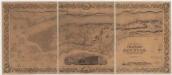
Topographical map of the city and county of New-York and the adjacent country : with views in the border of the principal buildings and interesting scenery of the island
1 : 16000 S. Stiles & Co Sherman & Smith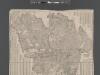
Street Indexed map of the Borough of Queens, also showing the Congressional Districts.
From Queens
Map of part of New York City, showing underground mains of the Edison Electric Illuminating Co. of New York.
From Manhattan
Map of New York City south of 118th street.
From Manhattan
New handy map of New York City.
From Manhattan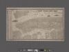
New York City map. Including an index to the streets of New York and Brooklyn.
From Manhattan
Map of the city and county of New York, showing routes and stations of the elevated railroads.
From Manhattan
Plate 6: Plan of New York and Brooklyn.
from Atlas of New York and vicinity : from actual surveys / by and under the direction of F. W. Beers, assisted by A. B. Prindle & others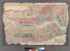
Plates 11 & 12: Map of New York City and central portion of Brooklyn.
from County atlas of Westchester, New York. Published by J.B. Beers & Co., assisted by S.W. Wilson and others.
Watson's New Map Of New-York And Adjacent Cities.
1 : 18600 Watson, Gaylord
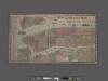
Goulding's Directory Map of New York City, including the two recently annexed wards, engraved from the latest and most accurate surveys.
From Manhattan