Maps of Bronx County

Planning Grid of the Office of the Topographical Bureau of Bronx.
from Topographical survey sheets of the borough of the Bronx easterly of the Bronx River.
Bronx, V. A, Plate No. 32 [Map bounded by Glebe Ave., St. Peter's St., Seabury Ave., Waterbury Ave., Glover St.]
From Vol. A
Unionport, Westchester and Schuylerville, New York.
1 : 8910 Beers, J.B.
Bronx, V. A, Plate No. 28 [Map bounded by Westchester Creek, Turnbull Ave., Havemeyer Ave., Ludlow Ave.]
From Vol. A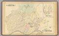
Unionport, W. Chester.
1 : 4800 Bromley, George Washington; Bromley, Walter Scott; G.W. Bromley & Co.
Planning Grid of the Office of the Topographical Bureau of Bronx.
from Topographical survey and new street system of the borough of the Bronx, easterly of the Bronx River
Sheet 18: Grid #16000E - 20000E, #1000S - 5000S. [Includes Morris Park Race Track, Morris Avenue, West Farms Road (Van Nest Station and Morris Park Station Rail Yards) and E. Tremont Avenue.]
from Topographical survey sheets of the borough of the Bronx easterly of the Bronx River.
Planning Grid of the Office of the Topographical Bureau of Bronx.
from Topographical survey sheets of the borough of the Bronx easterly of the Bronx River.
Sheet 31: Grid #24000E - 28000E, #1000S - 5000S. [Includes Union Port, Bowne Estate, Westchester Terrace, St. Raymond's Cemetery and Schuylerville.]
from Topographical survey sheets of the borough of the Bronx easterly of the Bronx River.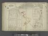
Bronx, V. 3, Double Page Plate No. 26 [Map bounded by West Farms Rd., Castle Hill Ave., McGraw Ave., Beach Ave.] / by George W. and Walter S. Bromley.
From Vol. 3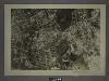
4C - N.Y. City (Aerial Set).
from Sectional aerial maps of the City of New York / [photographed and assembled under the direction of the chief engineer, July 1st, 1924].
Plate 16: Unionport - Westchester - Schuyerville :Town & County of Westchester, N.Y.
from Atlas of New York and vicinity : from actual surveys / by and under the direction of F. W. Beers, assisted by A. B. Prindle & others
Unionport, Schuylerville.
from County atlas of Westchester, New York. Published by J.B. Beers & Co., assisted by S.W. Wilson and others.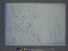
Height District Map Section No. 4; Height district map / City of New York, Board of Estimate and Apportionment.
from Height district map / City of New York, Board of Estimate and Apportionment. New York (N.Y.). Board of Estimate and Apportionment,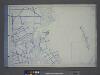
Use District Map Section No. 4; Use district map / City of New York, Board of Estimate and Apportionment.
from Use district map / City of New York, Board of Estimate and Apportionment. New York (N.Y.). Board of Estimate and Apportionment,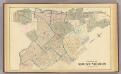
Mount Vernon.
1 : 7200 Bromley, George Washington; Bromley, Walter Scott; G.W. Bromley & Co.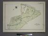
Plate 83, Part of Section 13, Borough of the Bronx. [Bounded by Webster Avenue, Bronx Boulevard, White Plains Road, E. 180th Street, Boston Road, E. 188th Street, Southern Boulevard and E. Fordham Road.]
from Atlas of borough of the Bronx, Sections 9 10 11 12 & 13 : from actual surveys and official plans / G.W. Bromley and Co.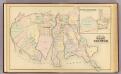
West Chester, Schuylerville.
1 : 14400 Bromley, George Washington; Bromley, Walter Scott; G.W. Bromley & Co.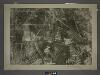
4A - N.Y. City (Aerial Set).
from Sectional aerial maps of the City of New York / [photographed and assembled under the direction of the chief engineer, July 1st, 1924].
Sheet 32: Grid #24000E - 28000E, #5000S - 9000S. [Includes from 1st Street to 10th Street, from Westchester Creek to Avenue B, Union Port, (St. Raymond's Cemetery) and Westchester Avenue.]
from Topographical survey sheets of the borough of the Bronx easterly of the Bronx River.
Sheet 17: Grid #16000E - 20000E, #1000S - 3000N. [Includes Morris Park Race Track, (Westchester Square) and Westchester Heights.]
from Topographical survey sheets of the borough of the Bronx easterly of the Bronx River.
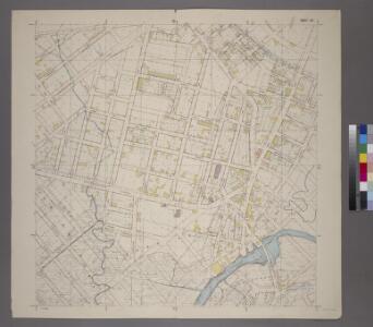
Sheet 19: Grid #16000E - 20000E, #5000S - 9000S. [Includes Westchester Avenue (Parkchester),Tremont Avenue, West Farms Road, Pugsley Street, Tompkin Street (White Plains Road) and Union Post Road.]
from Topographical survey and new street system of the borough of the Bronx, easterly of the Bronx River
Planning Grid of the Office of the Topographical Bureau of Bronx.
from Topographical survey sheets of the borough of the Bronx easterly of the Bronx River.
Area District Map Section No. 4
from Area district map / City of New York, Board of Estimate and Apportionment.
Westchester, Pelham towns.
1 : 21120 Bien, Joseph Rudolf
Hammods Atlas of New York City and the metropolitan district

Hammods Atlas of New York City and the metropolitan district

Flushing
1 : 24000
Flushing
1 : 24000
Flushing
1 : 24000
Flushing
1 : 24000
Flushing
1 : 24000
Flushing
1 : 24000
Flushing
1 : 24000
Flushing
1 : 24000