Maps of Queens County
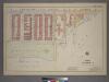
Plate 32, Part of Section 5: [Bounded by Avenue A, (East River) East End Avenue and E. 85th Street.]
from Atlas of the city of New York, borough of Manhattan. From actual surveys and official plans / by George W. and Walter S. Bromley.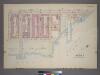
Plate 32, Part of Section 5: [Bounded by (East River Park) East End Avenue, E. 85th Street, Avenue A, E. 83rd Street and (East River) E. 89th Street.]
from Atlas of the city of New York, borough of Manhattan. From actual surveys and official plans / by George W. and Walter S. Bromley.
Part of Section 5: Plate 117.
from Atlas of the borough of Manhattan, city of New York.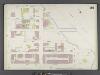
Manhattan, V. 8, Double Page Plate No. 161 [Map bounded by E. 93rd St., East River, E. 88th St., 1st Ave.]
From Atlas 122. Vol. 8, 1896.
[Plate 31: Bounded by Second Avenue, E. 101st Street, East River, Avenue B and and E. 84th Street.]
from Atlas of the city of New York, Manhattan Island. From actual surveys and official plans / by George W. and Walter S. Bromley.
Part of Sections 5 & 6 : New York City.
from Atlas of the city of New York, borough of Manhattan. From actual surveys and official plans / by George W. and Walter S. Bromley.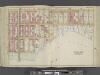
Manhattan, Double Page Plate No. 31 [Map bounded by 2nd Ave., E. 101st St., East River, E. 84th St.]
From Atlas of the city of New York, Manhattan Island. From actual surveys and official plans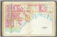
Pl. 31: wards 12, 19.
1 : 1800 Bromley, George Washington; Bromley, Walter Scott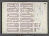
Manhattan, V. 8, Double Page Plate No. 160 [Map bounded by E. 88th St., East River, E. 82nd St., 1st Ave.]
From Atlas 122. Vol. 8, 1896.
Part of Section 5: Plate 115.
from Atlas of the borough of Manhattan, city of New York.
Plate 31, Part of Section 5: [Bounded by E. 89th Street, Avenue A, E. 83rd Street and Third Avenue.]
from Atlas of the city of New York, borough of Manhattan. From actual surveys and official plans / by George W. and Walter S. Bromley.
Plate 31, Part of Section 5: [Bounded by E. 89th Street, Avenue A, E. 83rd Street and Third Avenue.]
from Atlas of the city of New York, borough of Manhattan. From actual surveys and official plans / by George W. and Walter S. Bromley.
[Plate 119: Bounded by E. 95th Street, East River, Avenue A, E. 89th Street and Third Avenue.]
from Atlas of the borough of Manhattan, city of New York.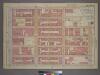
Plate 33, Part of Section 5: [Bounded by E. 95th Street, First Avenue, E. 93rd Street, Avenue A, E. 89th Street and Third Avenue.]
from Atlas of the city of New York, borough of Manhattan. From actual surveys and official plans / by George W. and Walter S. Bromley.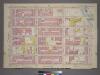
Plate 33, Part of Section 5: [Bounded by E. 95th Street, First Avenue, E. 93rd Street, Avenue A, E. 89th Street and Third Avenue.]
from Atlas of the city of New York, borough of Manhattan. From actual surveys and official plans / by George W. and Walter S. Bromley.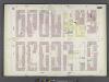
Manhattan, V. 8, Double Page Plate No. 162 [Map bounded by 3rd Ave., E. 93rd St., 1st Ave., E. 86th St.]
From Atlas 122. Vol. 8, 1896.
Queens V. 2, Plate No. 3 [Map bounded by Franklin, Halsey, East River]
From Atlas 134. Vol. 2, 1915.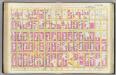
Pl. 30: ward 12, 19.
1 : 1800 Bromley, George Washington; Bromley, Walter Scott
Sackersdorff Farm Set.
from Sackersdorf Farm Set.
Map of the Village of Astoria, queens Co., N.Y.
From Queens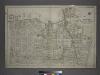
[Plate 2: Bounded by (East River) Vernon Avenue, Boulevard, Fulton Avenue, Mill Street, Orchard Street, Boulevard, Hoyt Avenue, Barclay Street, Woolsey Avenue, Rapelje Avenue and Freeman Avenue.]
from Atlas of the city of New York, borough of Queens, Long Island City, Newtown, Flushing, Jamaica, Far Rockaway, from actual surveys and official plans / by George W. and Walter S. Bromley.
Sheet 14: [Bounded by E. Ninety Second Street, Avenue A, E. Nintieth Street, Avenue B, E. Seventy Second Street, Avenue A, [E. Fifty Ninth Street] and 5th Avenue.]
from Plan of New York City, from the Battery to Spuyten Duyvil Creek. Showing every lot and building thereon; old farm lines, strreet numbers at the corners of blocks, railroads, steamboat landings, bulkhead and pier lines, etc. Based on the surveys made by Messrs. Randall & Blackwell, and on the special survey by J. F. Harrison.
Part of Ward 12, New York City.
from Atlas of the city of New York : embracing all territory within its corporate limits from official records, private plans & actual surveys / by and under the supervision of E. Robinson & R.H. Pidgeon, civil engineers.
Part of Wards 19 & 20, New York City.
from Atlas of the city of New York : embracing all territory within its corporate limits from official records, private plans & actual surveys / by and under the supervision of E. Robinson & R.H. Pidgeon, civil engineers.
22. Ward 12.
1 : 2400 G.W. Bromley & Co.; Geo. W. Bromley & E. Robinson
21. Ward 19.
1 : 2400 G.W. Bromley & Co.; Geo. W. Bromley & E. Robinson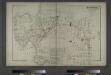
Astoria. Part of Long Island City, Town of Newtown, Queens Co. L.I.
from Atlas of Long Island, New York. From recent and actual surveys and records.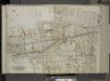
Queens, Vol. 2, Double Page Plate No. 8; Part of Long Island City Ward One (Part of Old Wards 4 and 5); [Map bounded by Hoyt Ave., Emily Terrace, Edward St., Barclay St., Vanalst Ave., Woolsey Ave., De Bevoise Ave. (Bradford St.), Lockwood St.,
from First and second wards: Long Island City and Newtown.
[Plate 29: Bounded by Second Avenue, E. 84th Street, East End Avenue, [East River] Exterior Street, and E. 68th Street.]
from Atlas of the city of New York, borough of Manhattan. From actual surveys and official plans / by George W. and Walter S. Bromley.
![Plate 32, Part of Section 5: [Bounded by Avenue A, (East River) East End Avenue and E. 85th Street.]](https://images-2.georeferencer.com/images/iiif/115932952529/full/,300/0/native.jpg)

