Maps of Queens County
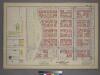
Plate 14, Part of Sections 4&7: [Bounded by W. 100th Street, Amsterdam Avenue, W. 95th Street and (Riverside Park) Riverside Drive.]
from Atlas of the city of New York, borough of Manhattan. From actual surveys and official plans / by George W. and Walter S. Bromley.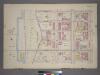
Plate 14, Part of Sections 4&7: [Bounded by W. 100th Street, Amsterdam Avenue, W. 95th Street and Riverside Drive.]
from Atlas of the city of New York, borough of Manhattan. From actual surveys and official plans / by George W. and Walter S. Bromley.
Part of Sections 4 & 7 : Plate 98.
from Atlas of the borough of Manhattan, city of New York.
Manhattan, V. 7, Plate No. 71 [Map bounded by Hudson River, Riverside Park]
From Atlas 120. Vol. 7, 1902.
Manhattan, V. 7, Plate No. 21 [Map bounded by W. 100th St., W. End Ave., W. 96th St., Riverside Ave.]
From Atlas 120. Vol. 7, 1902.
Manhattan, V. 7, Plate No. 22 [Map bounded by W. 100th St., Amsterdam Ave., W. 96th St., W. End Ave.]
From Atlas 120. Vol. 7, 1902.
Manhattan, V. 7, Plate No. 17 [Map bounded by W. 96th St., W. End Ave., W. 91st St., Riverside Ave.]
From Atlas 120. Vol. 7, 1902.
Manhattan, V. 7, Plate No. 72 [Map bounded by Hudson River, Riverside Park]
From Atlas 120. Vol. 7, 1902.
Manhattan, V. 7, Plate No. 18 [Map bounded by W. 96th St., Amsterdam Ave., W. 91st St., W. End Ave.]
From Atlas 120. Vol. 7, 1902.
Manhattan, V. 7, Plate No. 25 [Map bounded by W. 105th St., W. End Ave., W. 100th St., Hudson River]
From Atlas 120. Vol. 7, 1902.
Manhattan, V. 7, Plate No. 23 [Map bounded by W. 100th St., Columbus Ave., W. 96th St., Amsterdam Ave.]
From Atlas 120. Vol. 7, 1902.
[Plate 37: Bounded by W. 108th Street, Central Park West, W. 97th Street and (Hudson River) Riverside Drive.]
from Atlas of the city of New York, Manhattan Island. From actual surveys and official plans / by George W. and Walter S. Bromley.
[Plate 37: Bounded by W. 108th Street, Central Park West, W. 97th Street, and [Hudson River, Riverside Park] Riverside Drive.]
from Atlas of the city of New York, borough of Manhattan. From actual surveys and official plans / by George W. and Walter S. Bromley.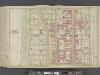
Manhattan, Double Page Plate No. 37 [Map bounded by W. 108th St., Central Park W., W. 97th St., Hudson River]
From Atlas of the city of New York, Manhattan Island. From actual surveys and official plans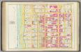
Pl. 37: ward 12.
1 : 1800 Bromley, George Washington; Bromley, Walter Scott
[Plate 100: Bounded by W. 105th Street, Amsterdam Avenue, W. 100th Street,and [Hudson River, Riverside Park] Riverside Drive.]
from Atlas of the borough of Manhattan, city of New York.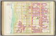
Pl. 36: ward 12.
1 : 1800 Bromley, George Washington; Bromley, Walter Scott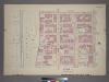
Plate 15, Part of Section 7: [Bounded by W. 105th Street, Amsterdam Avenue, W. 100th Street and (Hudson River - Riverside Park) Riverside Drive.]
from Atlas of the city of New York, borough of Manhattan. From actual surveys and official plans / by George W. and Walter S. Bromley.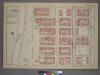
Plate 11, Part of Section 4: [Bounded by W. 95th Street, Amsterdam Avenue, W. 89th Street and (Riverside Park) Riverside Drive.]
from Atlas of the city of New York, borough of Manhattan. From actual surveys and official plans / by George W. and Walter S. Bromley.
Part of Section 4 : Plate 96.
from Atlas of the borough of Manhattan, city of New York.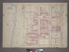
Plate 11, Part of Section 4: [Bounded by W. 95th Street, Amsterdam Avenue, W. 89th Street and (Hudson River - Riverside Park) Riverside Drive.]
from Atlas of the city of New York, borough of Manhattan. From actual surveys and official plans / by George W. and Walter S. Bromley.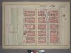
Plate 15, Part of Section 7: [Bounded by W. 105th Street, Amsterdam Avenue, W. 100th Street, and (Riverside Park) Riverside Drive.]
from Atlas of the city of New York, borough of Manhattan. From actual surveys and official plans / by George W. and Walter S. Bromley.
[Plate 99: Bounded by W. 100th Street, Central Park West, W. 95th Street, and Amsterdam Avenue.]
from Atlas of the borough of Manhattan, city of New York.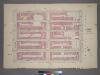
Plate 13, Part of Sections 4&7: [Bounded by W. 100th Street, Central Park West, W. 95th Street and Amsterdam Avenue.]
from Atlas of the city of New York, borough of Manhattan. From actual surveys and official plans / by George W. and Walter S. Bromley.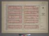
Plate 13, Part of Sections 4&7: [Bounded by W. 100th Street, Central Park West, W. 95th Street and Amsterdam Avenue.]
from Atlas of the city of New York, borough of Manhattan. From actual surveys and official plans / by George W. and Walter S. Bromley.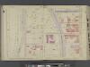
Manhattan, V. 6, Double Page Plate No. 5 [Map bounded by W. 106th St., 10th Ave., W. 102nd St., Riverside Ave.] / compiled from official records and actual surveys under the direction of E. Robinson and Roger H. Pidgeon.
From Vol. 6
Plate 101: Bounded by W. 105th Street, Central Park West, W. 100th Street and Amsterdam Avenue.
from Atlas of the borough of Manhattan, city of New York.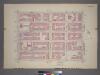
Plate 16, Part of Section 7: [Bounded by W. 105th Street, Amsterdam Avenue, W. 100th Street and (Hudson River - Riverside Park) Riverside Drive.]
from Atlas of the city of New York, borough of Manhattan. From actual surveys and official plans / by George W. and Walter S. Bromley.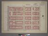
Plate 16, Part of Section 7: [Bounded by W. 105th Street, Central Park West, W. 100th Street and Amsterdam Avenue.]
from Atlas of the city of New York, borough of Manhattan. From actual surveys and official plans / by George W. and Walter S. Bromley.
![Plate 14, Part of Sections 4&7: [Bounded by W. 100th Street, Amsterdam Avenue, W. 95th Street and (Riverside Park) Riverside Drive.]](https://images-2.georeferencer.com/images/iiif/059947265280/full/,300/0/native.jpg)

