Maps of Hudson County
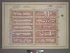
Plate 15, Part of Section 3: [Bounded by W. 31st Street, Seventh Avenue, W. 26th Street and Ninth Avenue.]
from Atlas of the city of New York, borough of Manhattan. From actual surveys and official plans / by George W. and Walter S. Bromley.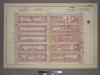
Plate 15, Part of Section 3: [Bounded by W. 31st Street, Seventh Avenue, W. 26th Street and Ninth Avenue.]
from Atlas of the city of New York, borough of Manhattan. From actual surveys and official plans / by George W. and Walter S. Bromley.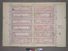
Plate 15, Part of Section 3: [Bounded by W. 32nd Street, Seventh Avenue, W. 26th Street and Ninth Avenue.]
from Atlas of the city of New York, borough of Manhattan. From actual surveys and official plans / by George W. and Walter S. Bromley.
Plate 54: Bounded by W. 31st Street, Seventh Avenue, W. 26th Street, and Ninth Avenue.
from Atlas of the borough of Manhattan, city of New York.
[Plate 90: Map bounded by West 32nd Street, Sixth Avenue, West 27th Street, Eighth Avenue.]
from Maps of the city of New York / surveyed under directions of insurance companies of said city.
Plate 88: Map bounded by West 32nd Street, Sixth Avenue, West 27th Street, Eighth Avenue
from Maps of the city of New York.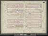
Manhattan, V. 5, Double Page Plate No. 89 [Map bounded by W. 32nd St., 8th Ave., W. 27th St., 10th Ave.]
From Atlas 42.55. Vol. 5, 1890.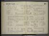
[Plate 87: Map bounded by West 27th Street, Sixth Avenue, West 22nd Street, Eighth Avenue.]
from Maps of the city of New York / surveyed under directions of insurance companies of said city.
Plate 89: Map bounded by West 32nd Street, Eighth Avenue, West 27th Street, Tenth Avenue
from Maps of the city of New York.
Part of Section 3 : Plate 48.
from Atlas of the borough of Manhattan, city of New York.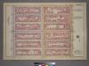
Plate 8, Part of Section 3: [Bounded by W. 26th Street, Seventh Avenue, W. 20th Street and (Chelsea Square) Ninth Avenue.]
from Atlas of the city of New York, borough of Manhattan. From actual surveys and official plans / by George W. and Walter S. Bromley.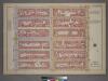
Plate 8, Part of Section 3: [Bounded by W. 26th Street, Seventh Avenue, W. 20th Street and Ninth Avenue.]
from Atlas of the city of New York, borough of Manhattan. From actual surveys and official plans / by George W. and Walter S. Bromley.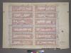
Plate 8, Part of Section 3: [Bounded by W. 26th Street, Seventh Avenue, W. 20th Street and Ninth Avenue.]
from Atlas of the city of New York, borough of Manhattan. From actual surveys and official plans / by George W. and Walter S. Bromley.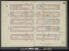
Manhattan, V. 5, Double Page Plate No. 85 [Map bounded by W. 27th St., 6th Ave., W. 22nd St., 8th Ave.]
From Atlas 42.55. Vol. 5, 1890.
Part of Section 3 : Plate 59.
from Atlas of the borough of Manhattan, city of New York.
[Plate 91: Map bounded by West 32nd Street, Eighth Avenue, West 27th Street, Tenth Avenue.]
from Maps of the city of New York / surveyed under directions of insurance companies of said city.
Plate 86: Map bounded by West 27th Street, Eighth Avenue, West 22nd Street, Tenth Avenue
from Maps of the city of New York.
Plate 85: Map bounded by West 27th Street, Sixth Avenue, West 22nd Street, Eighth Avenue
from Maps of the city of New York.
[Plate 88: Map bounded by West 27th Street, Eighth Avenue, West 22nd Street, Tenth Avenue.]
from Maps of the city of New York / surveyed under directions of insurance companies of said city.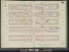
Manhattan, V. 5, Double Page Plate No. 86 [Map bounded by W. 27th St., 8th Ave., W. 22nd St., 10th Ave.]
From Atlas 42.55. Vol. 5, 1890.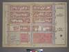
Plate 20, Part of Section 3: [Bounded by (W. 37th Street, Seventh Avenue, W. 31st Street and Ninth Avenue.]
from Atlas of the city of New York, borough of Manhattan. From actual surveys and official plans / by George W. and Walter S. Bromley.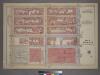
Plate 20, Part of Section 3: [Bounded by W. 37th Street, Seventh Avenue, W. 31st Street and Ninth Avenue.]
from Atlas of the city of New York, borough of Manhattan. From actual surveys and official plans / by George W. and Walter S. Bromley.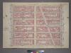
Plate 14, Part of Section 3: [Bounded by W. 32nd Street, Fifth Avenue, W. 26th Street and Seventh Avenue.]
from Atlas of the city of New York, borough of Manhattan. From actual surveys and official plans / by George W. and Walter S. Bromley.
Part of Section 3 : Plate 53.
from Atlas of the borough of Manhattan, city of New York.
Part of Section 3 : Plate 55.
from Atlas of the borough of Manhattan, city of New York.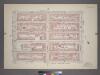
Plate 20, Part of Section 3: [Bounded by (W. 37th Street, Seventh Avenue, W. 32nd Street and Ninth Avenue.]
from Atlas of the city of New York, borough of Manhattan. From actual surveys and official plans / by George W. and Walter S. Bromley.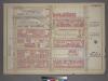
Plate 16, Part of Section 3: [Bounded by W. 32nd Street, Ninth Avenue, W. 26th Street and Eleventh Avenue.]
from Atlas of the city of New York, borough of Manhattan. From actual surveys and official plans / by George W. and Walter S. Bromley.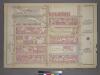
Plate 16, Part of Section 3: [Bounded by W. 32nd Street, Ninth Avenue, W. 26th Street and Eleventh Avenue.]
from Atlas of the city of New York, borough of Manhattan. From actual surveys and official plans / by George W. and Walter S. Bromley.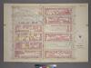
Plate 16, Part of Section 3: [Bounded by W. 32nd Street, Ninth Avenue, W. 26th Street and Eleventh Avenue.]
from Atlas of the city of New York, borough of Manhattan. From actual surveys and official plans / by George W. and Walter S. Bromley.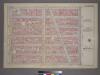
![Plate 15, Part of Section 3: [Bounded by W. 31st Street, Seventh Avenue, W. 26th Street and Ninth Avenue.]](https://images-2.georeferencer.com/images/iiif/256547524747/full/,300/0/native.jpg)

