Maps of Queens County
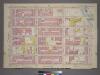
Plate 33, Part of Section 5: [Bounded by E. 95th Street, First Avenue, E. 93rd Street, Avenue A, E. 89th Street and Third Avenue.]
from Atlas of the city of New York, borough of Manhattan. From actual surveys and official plans / by George W. and Walter S. Bromley.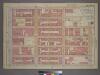
Plate 33, Part of Section 5: [Bounded by E. 95th Street, First Avenue, E. 93rd Street, Avenue A, E. 89th Street and Third Avenue.]
from Atlas of the city of New York, borough of Manhattan. From actual surveys and official plans / by George W. and Walter S. Bromley.
[Plate 119: Bounded by E. 95th Street, East River, Avenue A, E. 89th Street and Third Avenue.]
from Atlas of the borough of Manhattan, city of New York.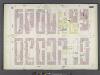
Manhattan, V. 8, Double Page Plate No. 162 [Map bounded by 3rd Ave., E. 93rd St., 1st Ave., E. 86th St.]
From Atlas 122. Vol. 8, 1896.
Manhattan, V. 8, Double Page Plate No. 165 [Map bounded by E. 98th St., East River, E. 93rd St., 3rd Ave.]
From Atlas 122. Vol. 8, 1896.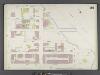
Manhattan, V. 8, Double Page Plate No. 161 [Map bounded by E. 93rd St., East River, E. 88th St., 1st Ave.]
From Atlas 122. Vol. 8, 1896.
22. Ward 12.
1 : 2400 G.W. Bromley & Co.; Geo. W. Bromley & E. Robinson
[Plate 31: Bounded by Second Avenue, E. 101st Street, East River, Avenue B and and E. 84th Street.]
from Atlas of the city of New York, Manhattan Island. From actual surveys and official plans / by George W. and Walter S. Bromley.
Part of Sections 5 & 6 : New York City.
from Atlas of the city of New York, borough of Manhattan. From actual surveys and official plans / by George W. and Walter S. Bromley.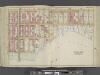
Manhattan, Double Page Plate No. 31 [Map bounded by 2nd Ave., E. 101st St., East River, E. 84th St.]
From Atlas of the city of New York, Manhattan Island. From actual surveys and official plans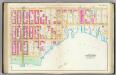
Pl. 31: wards 12, 19.
1 : 1800 Bromley, George Washington; Bromley, Walter Scott
Part of Section 5: Plate 117.
from Atlas of the borough of Manhattan, city of New York.
Part of Sections 5 & 6: Plate 121.
from Atlas of the borough of Manhattan, city of New York.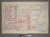
Plate 36, Part of Sections 5&6: [Bounded by E. 100th Street, (East River Piers) First Avenue, E. 95th Street and Third Avenue.]
from Atlas of the city of New York, borough of Manhattan. From actual surveys and official plans / by George W. and Walter S. Bromley.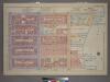
Plate 36, Part of Sections 5&6: [Bounded by E. 100th Street, First Avenue, E. 95th Street and Third Avenue.]
from Atlas of the city of New York, borough of Manhattan. From actual surveys and official plans / by George W. and Walter S. Bromley.
Plate 31, Part of Section 5: [Bounded by E. 89th Street, Avenue A, E. 83rd Street and Third Avenue.]
from Atlas of the city of New York, borough of Manhattan. From actual surveys and official plans / by George W. and Walter S. Bromley.
Plate 31, Part of Section 5: [Bounded by E. 89th Street, Avenue A, E. 83rd Street and Third Avenue.]
from Atlas of the city of New York, borough of Manhattan. From actual surveys and official plans / by George W. and Walter S. Bromley.
Part of Section 5: Plate 115.
from Atlas of the borough of Manhattan, city of New York.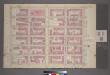
Plate 34, Part of Section 5: [Bounded by E. 95th Street, Third Avenue, E. 89th Street and Fifth Avenue.]
from Atlas of the city of New York, borough of Manhattan. From actual surveys and official plans / by George W. and Walter S. Bromley.
Plate 32, Part of Section 5: [Bounded by (East River Park) East End Avenue, E. 85th Street, Avenue A, E. 83rd Street and (East River) E. 89th Street.]
from Atlas of the city of New York, borough of Manhattan. From actual surveys and official plans / by George W. and Walter S. Bromley.
Part of Section 5: Plate 118.
from Atlas of the borough of Manhattan, city of New York.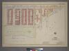
Plate 32, Part of Section 5: [Bounded by Avenue A, (East River) East End Avenue and E. 85th Street.]
from Atlas of the city of New York, borough of Manhattan. From actual surveys and official plans / by George W. and Walter S. Bromley.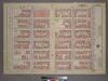
Plate 34, Part of Section 5: [Bounded by E. 95th Street, Third Avenue, E. 89th Street and Fifth Avenue.]
from Atlas of the city of New York, borough of Manhattan. From actual surveys and official plans / by George W. and Walter S. Bromley.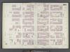
Manhattan, V. 8, Double Page Plate No. 163 [Map bounded by E. 94th St., 3rd Ave., E. 88th St., 5th Ave.]
From Atlas 122. Vol. 8, 1896.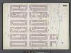
Manhattan, V. 8, Double Page Plate No. 160 [Map bounded by E. 88th St., East River, E. 82nd St., 1st Ave.]
From Atlas 122. Vol. 8, 1896.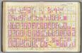
Pl. 30: ward 12, 19.
1 : 1800 Bromley, George Washington; Bromley, Walter Scott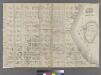
Part of Ward 12, New York City.
from Atlas of the city of New York : embracing all territory within its corporate limits from official records, private plans & actual surveys / by and under the supervision of E. Robinson & R.H. Pidgeon, civil engineers.
Sackersdorff Farm set.
from Maps of farms commonly called the Blue book, 1815 : drawn from the original on file in the street commissioner's office in the City of New York, together with lines of streets and avenues / laid out by John Randel, jr., 1819-20.
Sackersdorff Farm Set.
from Sackersdorf Farm Set.
![Plate 33, Part of Section 5: [Bounded by E. 95th Street, First Avenue, E. 93rd Street, Avenue A, E. 89th Street and Third Avenue.]](https://images-2.georeferencer.com/images/iiif/434973394666/full/,300/0/native.jpg)

