Maps of Queens County
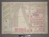
Plate 2, Part of Section 4: [Bounded by W. 65th Street,Amsterdam Avenue, W. 59th Street and (N.Y.C. & H.R.R.C.R. Union Stock Yards) West End Avenue.]
from Atlas of the city of New York, borough of Manhattan. From actual surveys and official plans / by George W. and Walter S. Bromley.
Part of Section 4 : Plate 86.
from Atlas of the borough of Manhattan, city of New York.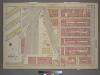
Plate 2, Part of Section 4: [Bounded by W. 65th Street, Amsterdam Avenue, W. 59th Street and (Hudson River Piers) West End Avenue.]
from Atlas of the city of New York, borough of Manhattan. From actual surveys and official plans / by George W. and Walter S. Bromley.
Manhattan, V. 6, Double Page Plate No. 114 [Map bounded by W. 67th St., Amsterdam Ave., W. 62nd St., 12th Ave.]
From Atlas 117. Vol. 6, 1892.
Plate 114: Map bounded by West 64th Street, Tenth Avenue, West 57th Street, Hudson River
from Maps of the city of New York.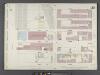
Manhattan, V. 6, Double Page Plate No. 113 [Map bounded by W. 62nd St., 10th Ave., W. 57th St., 12th Ave.]
From Atlas 117. Vol. 6, 1892.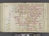
Manhattan, Double Page Plate No. 25 [Map bounded by W. 75th St., Central Park W., W. 64th St., Hudson River]
From Atlas of the city of New York, Manhattan Island. From actual surveys and official plans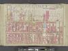
Manhattan, Double Page Plate No. 24 [Map bounded by Hudson River, W. 64th St., 9th Ave., W. 47th St.]
From Atlas of the city of New York, Manhattan Island. From actual surveys and official plans
[Plate 25: Bounded by W. 75th Street, Central Park West (8th Avenue), W. 64th Street and (Hudson River) Twelfth Avenue.]
from Atlas of the city of New York, Manhattan Island. From actual surveys and official plans / by George W. and Walter S. Bromley.
Part of Section 4 : New York City.
from Atlas of the city of New York, Manhattan Island. From actual surveys and official plans / by George W. and Walter S. Bromley.
[Plate 25: Bounded by W. 75th Street, Central Park West (8th Avenue), W. 64th Street, [Hudson River Piers E-I], W. 72nd Street, and Riverside Avenue.]
from Atlas of the city of New York, borough of Manhattan. From actual surveys and official plans / by George W. and Walter S. Bromley.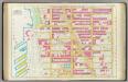
Pl. 25: ward 22.
1 : 1800 Bromley, George Washington; Bromley, Walter Scott
Manhattan, V. 6, Double Page Plate [Map of Hudson River Piers along 12th Ave.]
From Atlas 117. Vol. 6, 1892.
[Plate 24: Bounded by Twelfth Avenue [Hudson River Piers], W. 60th Street, West End Avenue, W. 64th Street, Columbus Avenue, and W. 47th Street.]
from Atlas of the city of New York, borough of Manhattan. From actual surveys and official plans / by George W. and Walter S. Bromley.
Part of Section 4 : Plate 88.
from Atlas of the borough of Manhattan, city of New York.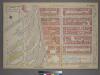
Plate 3, Part of Section 4: [Bounded by W. 71st Street, Amsterdam Avenue, W. 65th Street and (Hudson River Piers) West End Avenue.]
from Atlas of the city of New York, borough of Manhattan. From actual surveys and official plans / by George W. and Walter S. Bromley.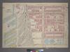
Plate 3, Part of Section 4: [Bounded by W. 71st Street,Amsterdam Avenue, W. 65th Street and (NewYork Central & Hudson River Rail Road Co.) West End Avenue.]
from Atlas of the city of New York, borough of Manhattan. From actual surveys and official plans / by George W. and Walter S. Bromley.
Plate 115: Map bounded by West 72nd Street, Tenth Avenue, West 64th Street, Hudson River
from Maps of the city of New York.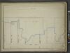
[Map bounded by Pier - Line, W. 61st St, Eleventh Avenue, W. 53th St; Including Twelfth Avenue, W. 54th St, W. 55th St, W. 56th St, W. 57th St, W. 58th St, W. 59st St, W. 60nd St]
from Maps of the wharves & piers from the Battery to 61st street on the Hudson river and from the Battery to 41st street on the East river, New York. Surveyed by I.C. Buckhout, city surveyor.
[Plate 81: Bounded by W. 59th Street, Ninth Avenue, W. 53rd Street, and Eleventh Avenue.]
from Atlas of the borough of Manhattan, city of New York.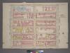
Plate 41, Part of Section 4: [Bounded by W. 59th Street, Ninth Avenue, W. 53rd Street and Eleventh Avenue.]
from Atlas of the city of New York, borough of Manhattan. From actual surveys and official plans / by George W. and Walter S. Bromley.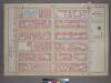
Plate 41, Part of Section 3: [Bounded by W. 59th Street, Ninth Avenue, W. 53rd Street and Eleventh Avenue.]
from Atlas of the city of New York, borough of Manhattan. From actual surveys and official plans / by George W. and Walter S. Bromley.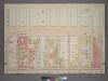
Plate 40, Part of Section 4: [Bounded by Twelfth Avenue (Hudson River Piers), W. 59th Street, Eleventh Avenue and W. 50th Street.]
from Atlas of the city of New York, borough of Manhattan. From actual surveys and official plans / by George W. and Walter S. Bromley.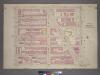
Plate 1, Part 1 of Section 4: [Bounded by W. 65th Street, Central Park West, W. 59th Street and Amsterdam Avenue.]
from Atlas of the city of New York, borough of Manhattan. From actual surveys and official plans / by George W. and Walter S. Bromley.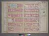
Plate 41, Part of Section 4: [Bounded by W. 59th Street, Ninth Avenue, W. 53rd Street and Eleventh Avenue.]
from Atlas of the city of New York, borough of Manhattan. From actual surveys and official plans / by George W. and Walter S. Bromley.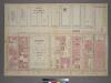
Plate 40, Part of Section 4: [Bounded by Twelfth Avenue (Hudson River Piers), W. 59th Street, Eleventh Avenue and W. 50th Street.]
from Atlas of the city of New York, borough of Manhattan. From actual surveys and official plans / by George W. and Walter S. Bromley.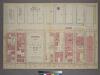
Plate 40, Part of Section 4: [Bounded by Twelfth Avenue (Hudson River Piers), W. 59th Street, Eleventh Avenue and W. 59th Street.]
from Atlas of the city of New York, borough of Manhattan. From actual surveys and official plans / by George W. and Walter S. Bromley.
Part of Section 4 : Plate 87.
from Atlas of the borough of Manhattan, city of New York.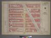
Plate 1, Part of Section 4: [Bounded by W. 65th Street, Central Park West, W. 59th Street and Amsterdam Avenue.]
from Atlas of the city of New York, borough of Manhattan. From actual surveys and official plans / by George W. and Walter S. Bromley.
![Plate 2, Part of Section 4: [Bounded by W. 65th Street,Amsterdam Avenue, W. 59th Street and (N.Y.C. & H.R.R.C.R. Union Stock Yards) West End Avenue.]](https://images-2.georeferencer.com/images/iiif/351884824936/full/,300/0/native.jpg)

