Maps of Queens County
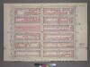
Plate 36, Part of Sections 4&5: [Bounded by W. 53rd Street, Fifth Avenue, W. 47th Street and Seventh Avenue.]
from Atlas of the city of New York, borough of Manhattan. From actual surveys and official plans / by George W. and Walter S. Bromley.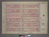
Plate 36, Part of Sections 4&5: [Bounded by W. 53rd Street, Fifth Avenue, W. 47th Street and Seventh Avenue.]
from Atlas of the city of New York, borough of Manhattan. From actual surveys and official plans / by George W. and Walter S. Bromley.
[Plate 77: Bounded by W. 53rd Street, Fifth Avenue, W. 47th Street, and Seventh Avenue.]
from Atlas of the borough of Manhattan, city of New York.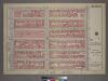
Plate 36, Part of Sections 4&5: [Bounded by W. 53rd Street, Fifth Avenue, W. 47th Street and Seventh Avenue.]
from Atlas of the city of New York, borough of Manhattan. From actual surveys and official plans / by George W. and Walter S. Bromley.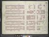
Manhattan, V. 4, Double Page Plate No. 84 [Map bounded by West 52nd St., East 52nd St., Park Ave., East 47th St., West 47th St., 6th Ave.]
From Atlas 113. Vol. 4, 1899.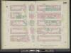
Manhattan, V. 5, Double Page Plate No. 100 [Map bounded by W. 52nd St., 6th Ave., W. 47th St., 8th Ave.]
From Atlas 42.55. Vol. 5, 1890.
Manhattan, V. 4, Double Page Plate No. 84 [Map bounded by W. 52nd St., E. 52nd St., Park Ave., E. 47th St., W. 47th St., 6th Ave.]
From Atlas 42.54. Vol. 4, 1890.
Plate 84: Map bounded by West 52nd Street, East 52nd Street, Fourth Avenue, East 52nd Street, West 52nd Street, Sixth Avenue
from Maps of the city of New York.
Plate 100: Map bounded by West 52nd Street, Sixth Avenue, West 47th Street, Eighth Avenue
from Maps of the city of New York.
Manhattan, V. 5, Plate No. 59 [Map bounded by Broadway, West 49th St., 6th Ave., West 46th St.]
From Atlas 116.1. Vol. 5, 1911.
Manhattan, V. 5, Plate No. 60 [Map bounded by 7th Ave., West 52nd St., 6th Ave., West 49th St.]
From Atlas 116.1. Vol. 5, 1911.
Manhattan, V. 5, Plate No. 48 [Map bounded by Broadway, West 46th St., 6th Ave., West 43rd St.]
From Atlas 116.1. Vol. 5, 1911.
Manhattan, V. 5, Plate No. 58 [Map bounded by 8th Ave., West 52nd St., 7th Ave., West 49th St.]
From Atlas 116.1. Vol. 5, 1911.
[Plate 23: Bounded by Ninth Avenue, Columbus Avenue, W. 64th Street, Central Park West, Columbus Circle, Central Park South, Sixth Avenue, and W. 47th Street.]
from Atlas of the city of New York, borough of Manhattan. From actual surveys and official plans / by George W. and Walter S. Bromley.
Part of Section 3 : New York City.
from Atlas of the city of New York, Manhattan Island. From actual surveys and official plans / by George W. and Walter S. Bromley.
Pl. 22: ward 19.
1 : 1800 Bromley, George Washington; Bromley, Walter Scott
[Plate 72: Bounded by W. 47th Street, Fifth Avenue, W. 42nd Street, and Broadway.]
from Atlas of the borough of Manhattan, city of New York.
Plate 31, Part of Sections 4&5: [Bounded by W. 47th Street, Fifth Avenue, W. 42nd Street and Seventh Avenue.]
from Atlas of the city of New York, borough of Manhattan. From actual surveys and official plans / by George W. and Walter S. Bromley.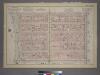
Plate 31, Part of Sections 4&5: [Bounded by W. 47th Street, Fifth Avenue, W. 42nd Street and Seventh Avenue.]
from Atlas of the city of New York, borough of Manhattan. From actual surveys and official plans / by George W. and Walter S. Bromley.
[Plate 83: Bounded by Central Park South, Fifth Avenue, W. 53rd Street, and Seventh Avenue.]
from Atlas of the borough of Manhattan, city of New York.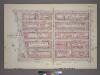
Plate 31, Part of Sections 4&5: [Bounded by W. 47th Street, Fifth Avenue, W. 42nd Street and Seventh Avenue.]
from Atlas of the city of New York, borough of Manhattan. From actual surveys and official plans / by George W. and Walter S. Bromley.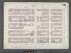
Manhattan, V. 6, Double Page Plate No. 106 [Map bounded by W. 57th St., E. 57th St., Park Ave., E. 52nd St., W. 52nd St., 6th Ave.]
From Atlas 117. Vol. 6, 1892.
[Plate 84: Bounded by E. 59th Street, Third Avenue, E. 53rd Street, and Fifth Avenue.]
from Atlas of the borough of Manhattan, city of New York.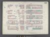
Manhattan, V. 6, Double Page Plate No. 105 [Map bounded by W. 57th St., 6th Ave., W. 52nd St., 8th Ave.]
From Atlas 117. Vol. 6, 1892.
Plate 106: Map bounded by West 57th Street, East 57th Street, Fourth Avenue, East 57th Street, West 57th Street, Sixth Avenue
from Maps of the city of New York.
Plate 43, Part of Sections 4&5: [Bounded by Central Park South, Fifth Avenue, W. 53rd Street and Seventh Avenue.]
from Atlas of the city of New York, borough of Manhattan. From actual surveys and official plans / by George W. and Walter S. Bromley.
Plate 43, Part of Sections 4&5: [Bounded by Central Park South, Fifth Avenue, W. 53rd Street and Seventh Avenue.]
from Atlas of the city of New York, borough of Manhattan. From actual surveys and official plans / by George W. and Walter S. Bromley.
Plate 43, Part of Sections 4&5: [Bounded by Central Park South, Fifth Avenue, W. 53rd Street and Seventh Avenue.]
from Atlas of the city of New York, borough of Manhattan. From actual surveys and official plans / by George W. and Walter S. Bromley.
[Plate 76: Bounded by W. 53rd Street, Seventh Avenue, W. 47th Street, and Ninth Avenue.]
from Atlas of the borough of Manhattan, city of New York.
![Plate 36, Part of Sections 4&5: [Bounded by W. 53rd Street, Fifth Avenue, W. 47th Street and Seventh Avenue.]](https://images-2.georeferencer.com/images/iiif/208156522320/full/,300/0/native.jpg)

