Maps of Queens County
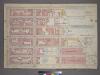
Plate 11, Part of Section 3: [Bounded by E. 26th Street, First Avenue, E. 24th Street, Avenue A, E. 21st Street, Avenue B, E. 20th Street and Second Avenue.]
from Atlas of the city of New York, borough of Manhattan. From actual surveys and official plans / by George W. and Walter S. Bromley.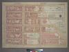
Plate 11, Part of Section 3: [Bounded by E. 26th Street, First Avenue, E. 24th Street, Avenue A, E. 23rd Street, Exterior Street, E. 20th Street and Second Avenue.]
from Atlas of the city of New York, borough of Manhattan. From actual surveys and official plans / by George W. and Walter S. Bromley.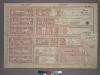
Plate 11, Part of Section 3: [Bounded by E. 26th Street, First Avenue, E. 24th Street, Avenue A, E. 21st Street, Avenue B, E. 20th Street and Second Avenue.]
from Atlas of the city of New York, borough of Manhattan. From actual surveys and official plans / by George W. and Walter S. Bromley.
[Plate 51: Bounded by E. 26th Street, East River [Piers 74-70], Exterior Street, E. 20th Street, and Second Avenue.]
from Atlas of the borough of Manhattan, city of New York.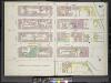
Manhattan, V. 4, Double Page Plate No. 67 [Map bounded by East 26th St., Avenue A., East 22nd St., 2nd Ave.]
From Atlas 113. Vol. 4, 1899.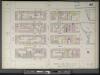
Manhattan, V. 4, Double Page Plate No. 67 [Map bounded by E. 26th St., East River, E. 22nd St., 2nd Ave.]
From Atlas 42.54. Vol. 4, 1890.
[Plate 75: Map bounded by East 26th Street, Avenue A, East 22nd Street, Second Avenue.]
from Maps of the city of New York / surveyed under directions of insurance companies of said city.
Plate 67: Map bounded by East 26th Street, East River, East 22nd Street, Second Avenue
from Maps of the city of New York.
[Map bounded by Avenue B, Avenue A, E. 24th St, Bulkhead Line, E. 17th St; Including Avenue C, Tompkins St, E. 18th St, E. 19th St, E. 20th St, E. 21st St, E. 22nd St, E. 23rd St, Ferry to Greenpoint]
from Maps of the wharves & piers from the Battery to 61st street on the Hudson river and from the Battery to 41st street on the East river, New York. Surveyed by I.C. Buckhout, city surveyor.
[Plate 46: Map bounded by East 22nd Street, Avenue A, East 17th Street, Second Avenue; Including East 21st Street, East 20th Street, East 19th Street, East 18th Street, First Avenue]
from Insurance maps of the city of New York.
Plate 46: Map bounded by East 22nd Street, East River, East 20th Street, Avenue A, East 17th Street, Second Avenue
from Maps of the city of New York.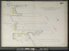
Manhattan, V. 4, Double Page Plate No. 67 1/2 [Map bounded by East River, E. 22nd St., Avenue A]
From Atlas 42.54. Vol. 4, 1890.
Plate 54: Map bounded by East 22nd Street, East River, East 20th Street, Avenue A, East 17th Street, Second Avenue.
from Maps of the city of New York / surveyed under directions of insurance companies of said city.
Manhattan, V. 4, Plate No. 9 [Map bounded by E. 26th St., 1st Ave., E. 22nd St., 2nd Ave.]
From Atlas 114. Vol. 4, 1910.
Manhattan, V. 2, Plate No. 49 [Map bounded by E. 22nd St., Avenue A, E. 18th St., 1st Ave.]
From Atlas 110. Vol. 2, 1903.
Manhattan, V. 4, Double Page Plate No. 70 [Map bounded by East 31st St., East River, East 26th St., 2nd Ave.]
From Atlas 113. Vol. 4, 1899.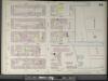
Manhattan, V. 4, Double Page Plate No. 70 [Map bounded by E. 31st St., East River, E. 26th St., 2nd Ave.]
From Atlas 42.54. Vol. 4, 1890.
Manhattan, V. 2, Plate No. 56 [Map bounded by East River, Marfinal St.]
From Atlas 110. Vol. 2, 1903.
Manhattan, V. 2, Plate No. 38 [Map bounded by E. 18th St., Avenue A, E. 14th St., 1st Ave.]
From Atlas 110. Vol. 2, 1903.
Plate 15: Bounded by E. 25th Street, Avenue A, E. 20th Street, Avenue B, E. 18th Street, Avenue C. E. 16th Street, Avenue D, E. 14th Street and Second Avenue.
from Atlas of the city of New York, Manhattan Island. From actual surveys and official plans / by George W. and Walter S. Bromley.
[Plate 15: Bounded by [Plate 32: Bounded by E. 25th Street, Exterior Street [East River], Avenue C, E. 14th Street, and Second Avenue.]
from Atlas of the city of New York, borough of Manhattan. From actual surveys and official plans / by George W. and Walter S. Bromley.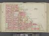
Manhattan, Double Page Plate No. 15 [Map bounded by E. 25th St., East River, E. 14th St., 2nd Ave.]
From Atlas of the city of New York, Manhattan Island. From actual surveys and official plans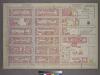
Plate 12, Part of Section 3: [Bounded by E. 32nd Street, First Avenue, E. 26th Street and Second Avenue.]
from Atlas of the city of New York, borough of Manhattan. From actual surveys and official plans / by George W. and Walter S. Bromley.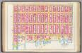
Pl. 16: wards 18, 21.
1 : 1800 Bromley, George Washington; Bromley, Walter Scott
Part of Section 3 : Plate 57.
from Atlas of the borough of Manhattan, city of New York.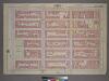
Plate 2, Part of Section 3: [Bounded by E. 20th Street, Avenue B, E. 14th Street, and Second Avenue.]
from Atlas of the city of New York, borough of Manhattan. From actual surveys and official plans / by George W. and Walter S. Bromley.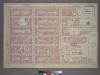
Plate 12, Part of Section 3: [Bounded by E. 32nd Street, (East River Piers) First Avenue, E. 26th Street and Third Avenue.]
from Atlas of the city of New York, borough of Manhattan. From actual surveys and official plans / by George W. and Walter S. Bromley.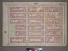
Plate 2, Part of Section 3: [Bounded by E. 20th Street, Avenue B, E. 14th Street and Second Avenue.]
from Atlas of the city of New York, borough of Manhattan. From actual surveys and official plans / by George W. and Walter S. Bromley.
Part of Section 3 : Plate 45.
from Atlas of the borough of Manhattan, city of New York.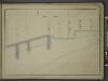
![Plate 11, Part of Section 3: [Bounded by E. 26th Street, First Avenue, E. 24th Street, Avenue A, E. 21st Street, Avenue B, E. 20th Street and Second Avenue.]](https://images-2.georeferencer.com/images/iiif/484064243071/full/,300/0/native.jpg)

