Maps of Woodmere

Maps of Woodmere

$title$

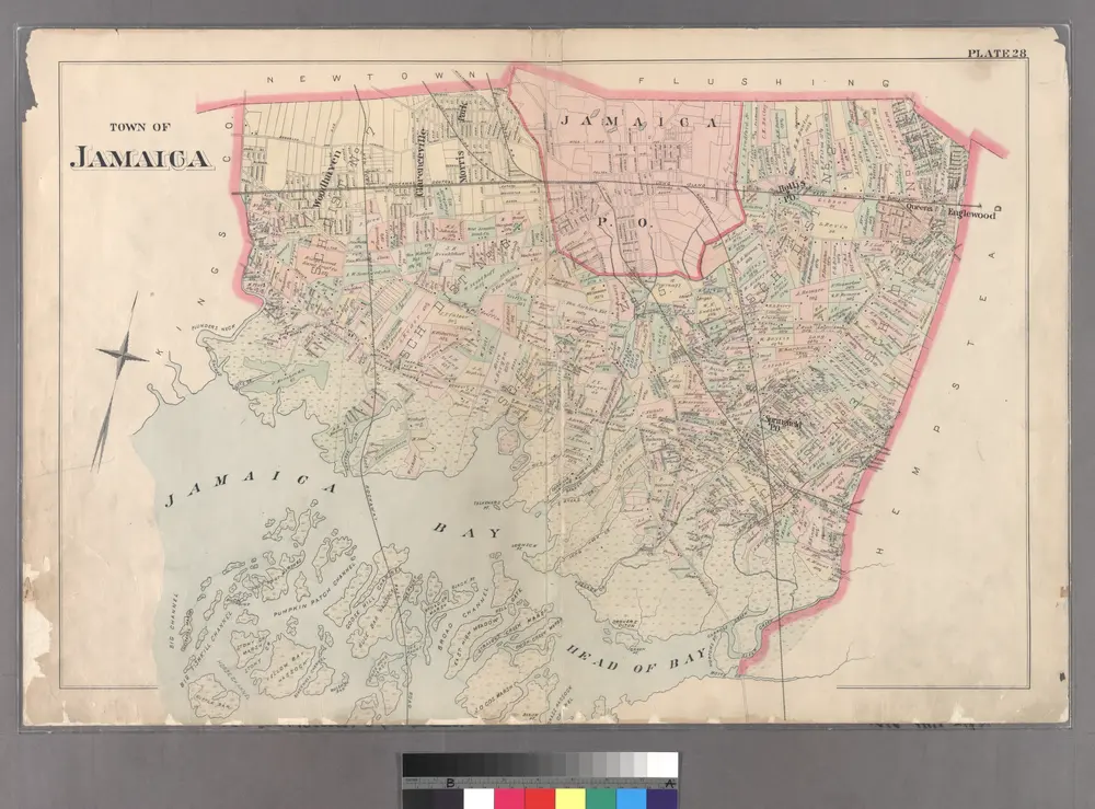
Plate 28: Town of Jamaica.

from Atlas of Queens Co., Long Island, New York / compiled from official records, private plans & actual surveys by and under the direction of Chester Wolverton.
$title$

General map of the city of New York, consisting of boroughs of Manhattan, Brooklyn, Bronx, Queens and Richmond : consolidated into one municipality by act of the legislature of the state of New York (Chapter 378 of the laws of 1897) : showing in addition

from Whole
$title$

Jamaica.- Part of Hempstead, Tn. of Hempstead, Queens Co.

from Atlas of Long Island, New York. From recent and actual surveys and records.
$title$

Jamaica

1 : 24000
$title$

Jamaica

1 : 24000
$title$

Jamaica

1 : 24000
$title$

Jamaica

1 : 24000
$title$

Jamaica

1 : 24000
$title$

Jamaica

1 : 24000
$title$

Map showing the old high water lines along the shores of Brooklyn & New York together the the pier lines as established by law.

From Manhattan
$title$

Lynbrook

1 : 24000
$title$

Lynbrook

1 : 24000
$title$

Lynbrook

1 : 24000
$title$

Lynbrook

1 : 24000
$title$

Lynbrook

1 : 24000
$title$

Index to Volume Four. Atlas of the Borough of Brooklyn. Sections 12, 13 & 14. Wards 26 and part of 29 & 32. City of New York. E. Belcher Hyde, 97 Liberty St., Brooklyn Borough. 1904.

from Wards 26 and part of 29 & 32.
$title$

New Lots. Kings Co. L.I.

from Atlas of Long Island, New York. From recent and actual surveys and records.
$title$

Key

From Atlas 142a, Vol. 6, 1911.
$title$

Key Continued

From Atlas 139. Vol. 4, 1901.
$title$

Queens, Vol. 1, Double Page Plate No. 18; Part of Ward 4; Jamaica; [Map bounded by South St., Country Road, Old Country Road, Jamaica Plank Road; Including Boundary Line Of City Of New York, Ocean Ave., Farmers Ave., Rockaway Turnpike, Th

from Fourth and fifth wards: Jamaica and Rockaway.
$title$

Inwood, Cedarhurst Vicinity

from Atlas of Nassau County, Long Island, N.Y. Complete in one volume. Historical, statistical. Based upon maps on file at the county seat in Mineola and upon private plans and surveys furnished by surveyors and individual owners. Supplemented by careful measurements & field observations by our own corps of engineers.
$title$

Queens, Vol. 1, Double Page Plate No. 17; Part of Ward 4; Jamaica; [Map bounded by Liberty Ave., Rockaway Turnpike, Mile Hill Road; Including Corn Fill Creek, Spring Creek]

from Fourth and fifth wards: Jamaica and Rockaway.
$title$

Part of the Borough of Queens, Jamaica, Ward 4.

from Atlas of the city of New York, borough of Queens, Long Island City, Newtown, Flushing, Jamaica, Far Rockaway, from actual surveys and official plans / by George W. and Walter S. Bromley.
$title$

Plate 14: Villages of Woodsburgh, Cedarhurst and Lawrence, Town of Hempstead.

from Atlas of Queens Co., Long Island, New York / compiled from official records, private plans & actual surveys by and under the direction of Chester Wolverton.
$title$

Brooklyn, Vol. 1, 2nd Part, Double Page Plate No. 50; Part of Wards 26, Section 14; [Map bounded by Vandalia Ave., Fountain Ave., Vandalia Ave.; Including Spring Creek, Jamaica Bay, Jerome St.] / by and under the direction of Hugo Ullitz.

From Volume 1
$title$

[Plate 42: Bounded by Central Avenue, (Springfield, Laurelton, Rosedale Terrace) Springfield Road, (Springfield Park, High View Park, Higbie Park), Higbie Avenue, Farmers Avenue, Merrick Plank Road, Locust Avenue and (Locust Manor, Cedar Manor) Smith Ave

from Atlas of the city of New York, borough of Queens, Long Island City, Newtown, Flushing, Jamaica, Far Rockaway, from actual surveys and official plans / by George W. and Walter S. Bromley.
$title$

Queens, Vol. 1, Double Page Plate No. 19; Part Of Ward 4; Jamaica; [Map bounded by Conduit Long Island R.R., Boundary Line Of The City of New York; Including Hook Canal Creek, Jamaica Bay, Dead or Salt Creek.]; Sub Plan From Plate No. 17 [Map bou

from Fourth and fifth wards: Jamaica and Rockaway.
$title$

Key Continued

From Atlas 137a. Vol. 3, 1914.
$title$

Springfield Store. Tn. of Jamaica, Queens Co. - Willow Tree Station. Town of Jamaica, Queens Co. - Inglewood or Queens. Town of Hempstead, Queens Co.

from Atlas of Long Island, New York. From recent and actual surveys and records.
$title$

[Plate 18: Bounded by Remsen Street, North Hempstead Plank Road, Corona Avenue, Strongs Causeway, Douglass Street (Queensboro Hills), Ireland Hill Road, North Hempstead Turnpike, Renwick Avenue, Union Avenue, Metropolitan Avenue and Trotting Course.]

from Atlas of the city of New York, borough of Queens, Long Island City, Newtown, Flushing, Jamaica, Far Rockaway, from actual surveys and official plans / by George W. and Walter S. Bromley.
© MapTiler © OpenStreetMap contributors
How does it work?
These instructions will show you how to find historical maps online.
Getting started
Type the place name in the search box to find the exact location. You can further adjust the search by zooming in and out.
Zoom
Zoom in and out with the buttons or use your mouse or touchpad natively.
Exact Area tool
Click here and draw a rectangle over the map to precisely define the search area.
Set filters
Narrow your search with advanced settings, such as Years (from/to), Fulltext, Publisher, etc.
Results
See the results of your search on the right side. You can scroll down to find more maps of this location.
?

Download OldMapsOnline Mobile