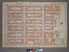
Maps of Queens County

Part of Long Island City, Ward No. 1 & 3.
from Atlas of Queens Co., Long Island, New York / compiled from official records, private plans & actual surveys by and under the direction of Chester Wolverton.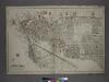
[Plate 1: Bounded by (East River) River Street, Dock Street, Front Street, Hunterspoint Avenue, West Avenue, Vernon Avenue, Freeman Avenue, Jackson Avenue, Thomson Avenue, Upton Street, Mott Avenue, Creek Street, Borden Avenue, Vernon and Flushing Street
from Atlas of the city of New York, borough of Queens, Long Island City, Newtown, Flushing, Jamaica, Far Rockaway, from actual surveys and official plans / by George W. and Walter S. Bromley.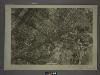
9C - N.Y. City (Aerial Set).
from Sectional aerial maps of the City of New York / [photographed and assembled under the direction of the chief engineer, July 1st, 1924].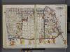
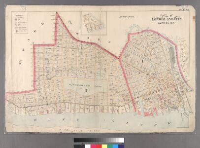
Queens, V. 2, Double Page Plate No. 2; Part of Long Island City, Ward 1; [Map bounded by Prospect St., 12th St., East River, Webster Ave.] / by and under the supervision of Hugo Ullitz.
From v. 2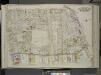
Queens, Vol. 2, Double Page Plate No. 2; Part of Long Island City Ward one (Part of Old Wards 1 and 3); [Map bounded by Prospect St., Harris Ave., Hunter Ave., Jackson Ave., 12th St., Division St., West Ave., 13th St., 14th St., Englis St., Bodine S
from First and second wards: Long Island City and Newtown.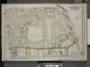
Queens, Vol. 2, Double Page Plate No. 2; Part of Long Island City Ward One (Part of Old Ward 1& 3). [Map bounded by Webster Ave., Freeman Ave., Vernon Ave., Payntar Ave., Beebe Ave., Wilbur Ave., Harris Ave., Jackson Ave., Nott Ave., West Ave.,
from Long Island City.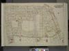
Queens, Vol. 2, Double Page Plate No. 2; Part of Long Island City Ward One (Part of Old Wards One and Three); [Map bounded by Prospect St., Harris Ave., Jackson Ave., 12th St., Vernon Ave., Division St., West Ave., Nott Ave., 13th St., 14th St., Engl
from First and second wards: Long Island City and Newtown.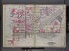
Queens, V. 2, Double Page Plate No. 1; Part of Long Island City, Ward 1; [Map bounded by 12th St., Ashburn St., Newtown Creek, East River] / by and under the supervision of Hugo Ullitz.
From v. 2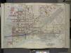
Queens, Vol. 2, Doble Page Plate No. 1; Part of Long Island City Ward One (Part of Old Ward 1); [Map bounded by Divison St., Vernon Ave., 12th St., Ely Ave., Homson Ave., Jackson Ave., Nott Ave., Creek Ave., Dutch Kill Creek, Newtown Creek; In
from First and second wards: Long Island City and Newtown.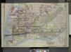
Queens, Vol. 2, Double Page Plate No. 1; Part of Long Island City Ward One (Part of Old Ward 1) Sub Plan; [Map bounded by Pier St., River St., Front St., Newtown Creek.]; Part of Long Island City Ward One (Part of Old Ward 1). [Map bounded by Eas
from Long Island City.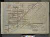
Queens, Vol. 2, Double Page Plate No. 1; Part of Long Island City Ward One (Part of Old Ward One); [Map bounded by Division St., Vernon Ave., 12th St., Ely Ave., Jackson Ave., Thomson Ave., Nott Ave., Creek St., Dutch Kill Creek, Newtown Cree
from First and second wards: Long Island City and Newtown.
Sackersdorff Farm Set.
from Maps of farms commonly called the Blue book, 1815 : drawn from the original on file in the street commissioner's office in the City of New York, together with lines of streets and avenues / laid out by John Randel, jr., 1819-20.
Sackersdorff Farm Set.
from Maps of farms commonly called the Blue book, 1815 : drawn from the original on file in the street commissioner's office in the City of New York, together with lines of streets and avenues / laid out by John Randel, jr., 1819-20.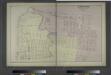
Ravenswood. Part of Long Island City. Queens Co. L.I.
from Atlas of Long Island, New York. From recent and actual surveys and records.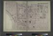
Hunters Point. Part of Long Island City.
from Atlas of Long Island, New York. From recent and actual surveys and records.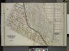
Queens, Vol. 2, Double Page Plate No. 3; Part of Long Island City Ward One (Part of Old Ward 2, 3 & 4). [Map bounded by Washington Ave., Webster Ave., Freeman Ave., Rapelje Ave., Beebe Ave., Payntar Ave., Wilbur Ave., Hunter Ave., Jackson Ave., Th
from Long Island City.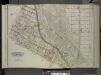
Queens, Vol. 2, Double Page Plate No. 3; Part of Long Island City Ward One (Part of Old Wards 2, 3 and 4); [Map bounded by Washington Ae., Pomeroy St. (8th Ave.), Jackson Ave., Skillman Ave., Van Pelt St., Nott Ave.; Including Thomson Ave., Purve
from First and second wards: Long Island City and Newtown.
Queens, Vol. 2, Double Page Plate No. 3; Part of Long Island City Ward One (Part of Old Wards Two, Three and Four); [Map bounded by Van Pelt St., Nott Ave., Creek St., Meadow St., Purves St., Hunter Ave., Prospect St.; Including Webster Ave
from First and second wards: Long Island City and Newtown.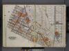
Queens, V. 2, Double Page Plate No. 3; Part of Long Island City, Ward 1; [Map bounded by Van Pelt St., Nelson Ave., Prospect St., Washington Ave.] / by and under the supervision of Hugo Ullitz.
From v. 2
Part of Section 5: New York City.
from Atlas of the city of New York, borough of Manhattan. From actual surveys and official plans / by George W. and Walter S. Bromley.
[Plate 21: Bounded by Lexington Avenue, E. 57th Street, Avenue A, E. 54th Street, First Avenue (East River), and E. 40th Street.]
from Atlas of the city of New York, Manhattan Island. From actual surveys and official plans / by George W. and Walter S. Bromley.
Manhattan, Double Page Plate No. 21 [Map bounded by Lexington Ave., E. 57th St., East River, E. 40th St.]
From Atlas of the city of New York, Manhattan Island. From actual surveys and official plans
[Plate 85: Bounded by E. 59th Street, Avenue A [East River], E. 53rd Street and Third Avenue.]
from Atlas of the borough of Manhattan, city of New York.
Plate 105: Bounded by E. 65th Street, Avenue A, E. 60th Street, Second Avenue, E. 59th Street and Third Avenue.
from Atlas of the borough of Manhattan, city of New York.
Part of Section 5 : New York City.
from Atlas of the city of New York, borough of Manhattan. From actual surveys and official plans / by George W. and Walter S. Bromley.
Part of Section 5 : Plate 79.
from Atlas of the borough of Manhattan, city of New York.
Plate 21, Part of Section 5: [Bounded by E. 65th Street, Avenue A, E. 67th Street and Exterior Street.]
from Atlas of the city of New York, borough of Manhattan. From actual surveys and official plans / by George W. and Walter S. Bromley.
Plate 45, Part of Section 5: [Bounded by E. 59th Street, (East River Piers) Avenue A, E. 53rd Street and Third Avenue.]
from Atlas of the city of New York, borough of Manhattan. From actual surveys and official plans / by George W. and Walter S. Bromley.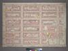
Plate 45, Part of Section 5: [Bounded by E. 59th Street, (East River Piers) Avenue A, E. 53rd Street and Third Avenue.]
from Atlas of the city of New York, borough of Manhattan. From actual surveys and official plans / by George W. and Walter S. Bromley.