Maps of Queens County

Sheet 8: Map encompassing Greenpoint and North Williamsburg.
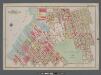
from Map of the city of Brooklyn : being the former cities of Brooklyn & Williamsburgh and the town of Bushwick, as consolidated January 1st, 1855 by an act of the legislature of the State of New York ... showing also a part of the City of New York.
Plan of the city of Brooklyn, L.I. / by William Perris.
from Brooklyn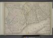
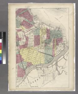
Brooklyn, Double Page Section 1; [Including wards 13, 14, 15, 16, 17, 18, 19]
from Farm line map of the city of Brooklyn, from official records and surveys; comp. and drawn by Henry Fulton.
Plan of the city of Brooklyn, L.I. / by William Perris.
from Brooklyn
13A - N.Y. City (Aerial Set).
from Sectional aerial maps of the City of New York / [photographed and assembled under the direction of the chief engineer, July 1st, 1924].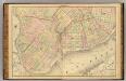
Sec. 1. Brooklyn map.
1 : 6000 Fulton, Henry; J.B. Beers & Co.
A map of the village of Williamsburgh, Kings County, N.Y. : showing each lot of ground in said village, as laid down on the assessment of the village, together with the assessment number of each lot / made by Isaac [V]ieth, under the supervision of Henry
from Brooklyn
Map of the City of Williamsburg and town of Bushwick, inclu. Greenpoint with part of the City of Brooklyn
From Brooklyn
Plan of the city of Brooklyn, L.I. / by William Perris.
from Brooklyn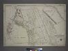
Part of the Borough of Queens, Long Island City, Ward 1.
from Atlas of the city of New York, borough of Queens, Long Island City, Newtown, Flushing, Jamaica, Far Rockaway, from actual surveys and official plans / by George W. and Walter S. Bromley.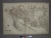
[Plate 1: Bounded by (East River) River Street, Dock Street, Front Street, Hunterspoint Avenue, West Avenue, Vernon Avenue, Freeman Avenue, Jackson Avenue, Thomson Avenue, Upton Street, Mott Avenue, Creek Street, Borden Avenue, Vernon and Flushing Street
from Atlas of the city of New York, borough of Queens, Long Island City, Newtown, Flushing, Jamaica, Far Rockaway, from actual surveys and official plans / by George W. and Walter S. Bromley.
Part of Long Island City, Ward No. 1 & 3.
from Atlas of Queens Co., Long Island, New York / compiled from official records, private plans & actual surveys by and under the direction of Chester Wolverton.
Part of Section 2 : Plate 26
from Atlas of the borough of Manhattan, city of New York.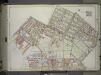
Brooklyn, Vol. 1, 2nd Part, Double Page Plate No. 33; Part of Wards 14, 15, 17, Section 8-9; [Map bounded by Meserole Ave., Jewel St., Nasau Ave., Humboldt St., Meeker Ave., Richardson St.; Including Union Ave., N. 9th St., East River, Greenpoint Ave....
From Volume 1, part 2
Part of Wards 14, 15 & 17. Land Map Sections, No. 8 & 9, Volume 1, Brooklyn Borough, New York City.
from Atlas of the Brooklyn borough of the City of New York : originally Kings Co.; complete in three volumes ... based upon official maps and plans ... / by and under the supervision of Hugo Ullitz, C.E.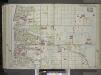
Brooklyn, Vol. 1, 2nd Part, Double Page Plate No. 36; Part of Wards 16 & 18, Section 10; [Map bounded by Richardson St. (Amos St.), Newtown Creek, Seneca Ave., Meserole Ave., Bushwick Ave.; Including Old Woodpoint Rd., Skillman Ave., Humboldt St., Ric...
From Volume 1
Part of Wards 17 & 18. Land Map Sections, No. 9 & 10, Volume 1, Brooklyn Borough, New York City.
from Atlas of the Brooklyn borough of the City of New York : originally Kings Co.; complete in three volumes ... based upon official maps and plans ... / by and under the supervision of Hugo Ullitz, C.E.
Part of Wards 16 & 18, Land Map Section, No. 10, Volume 1. Brooklyn Borough, New York City.
from Atlas of the Brooklyn borough of the City of New York : originally Kings Co.; complete in three volumes ... based upon official maps and plans ... / by and under the supervision of Hugo Ullitz, C.E.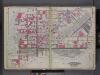
Queens, V. 2, Double Page Plate No. 1; Part of Long Island City, Ward 1; [Map bounded by 12th St., Ashburn St., Newtown Creek, East River] / by and under the supervision of Hugo Ullitz.
From v. 2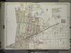
Brooklyn, Vol. 1, 2nd Part, Double Page Plate No. 35; Part of Wards 17 & 18, Section 9-10; [Map bounded by Calyer St., Newtown Creek, Richardson St. (Amos St.), Manhattan Ave., Meeker Ave.; Including Humboldt St., Nassau St., Jewel St., Meserole Ave.,...
From Volume 1, part 2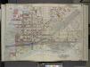
Queens, Vol. 2, Doble Page Plate No. 1; Part of Long Island City Ward One (Part of Old Ward 1); [Map bounded by Divison St., Vernon Ave., 12th St., Ely Ave., Homson Ave., Jackson Ave., Nott Ave., Creek Ave., Dutch Kill Creek, Newtown Creek; In
from First and second wards: Long Island City and Newtown.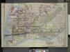
Queens, Vol. 2, Double Page Plate No. 1; Part of Long Island City Ward One (Part of Old Ward 1) Sub Plan; [Map bounded by Pier St., River St., Front St., Newtown Creek.]; Part of Long Island City Ward One (Part of Old Ward 1). [Map bounded by Eas
from Long Island City.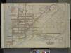
Queens, Vol. 2, Double Page Plate No. 1; Part of Long Island City Ward One (Part of Old Ward One); [Map bounded by Division St., Vernon Ave., 12th St., Ely Ave., Jackson Ave., Thomson Ave., Nott Ave., Creek St., Dutch Kill Creek, Newtown Cree
from First and second wards: Long Island City and Newtown.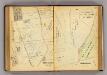
130-131 Greenburgh.
1 : 7200 G.W. Bromley & Co.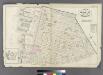
Plate 22: Bounded by N. 14th Street, Fifth Street, Union Avenue, N. 2nd Street, Third Street, N. 1st Street, River Street, N. 3rd Street and (East River) First Street.
from Atlas of the entire city of Brooklyn, complete in one volume. From actual surveys and official records by G. W. Bromley & Co.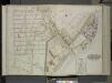
Queens, Vol. 2, Double Page Plate No. 4; Part of Long Island City Ward One (Part of Old Wards 1 and 2); [Map bounded by Van Pelt St., Greenpoint Ave., Hunters Point Ave., Borden Ave., Howard St., Spring St., Preston St.; Including Pine St., Va
from First and second wards: Long Island City and Newtown.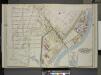
Queens, Vol. 2, Double Page Plate No. 4; Part of Long Island City Ward One (Part of Old Wards 1 & 2 ) Sub Plan; [Map bounded by Water St., Marsh St., Proposed Canal]; Part of Long Island City Ward One (Part of Old Wards 1 & 2 ) [Map bounded by Nott
from Long Island City.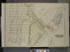
Queens, Vol. 2, Double Page Plate No. 4; Part of Long Island City Ward One (Part of Old Wards One and Two); [Map bounded by Van Pelt St., Greenpoint Ave., Hunters Point Ave., Borden Ave., Bradlay Ave.; Including Newtown Creek, Water St., Proposed
from First and second wards: Long Island City and Newtown.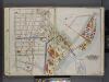
Queens, V. 2, Double Page Plate No. 4; Part of Long Island City, Ward 1; [Map bounded by Van Pelt St., Newtown Creek, Dutch Kills Canal, Nelson Ave.] / by and under the supervision of Hugo Ullitz.
From v. 2