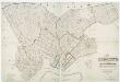
Maps of Hudson County

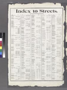
Index to Streets. Aberdeen Street - Junius Street.
from Atlas of the Brooklyn borough of the City of New York : originally Kings Co.; complete in three volumes ... based upon official maps and plans ... / by and under the supervision of Hugo Ullitz, C.E.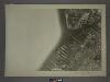
16C - N.Y. City (Aerial Set).
from Sectional aerial maps of the City of New York / [photographed and assembled under the direction of the chief engineer, July 1st, 1924].
Sheet 5: Map encompassing Red Hook, Cobble Hill, Carroll Gardens and Gowanus Canal.
from Map of the city of Brooklyn : being the former cities of Brooklyn & Williamsburgh and the town of Bushwick, as consolidated January 1st, 1855 by an act of the legislature of the State of New York ... showing also a part of the City of New York.
Brooklyn, Section 3; [Including Wards 12, 22]
from Farm line map of the city of Brooklyn, from official records and surveys; comp. and drawn by Henry Fulton.
Plan of the city of Brooklyn, L.I. / by William Perris.
from Brooklyn
Plan of the city of Brooklyn, L.I. / by William Perris.
from Brooklyn
Height District Map Section No. 16; Height district map / City of New York, Board of Estimate and Apportionment.
from Height district map / City of New York, Board of Estimate and Apportionment. New York (N.Y.). Board of Estimate and Apportionment,
Key
From Atlas 95. Vol. 11, 1905.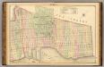
Sec. 6. Brooklyn map.
1 : 6000 Fulton, Henry; J.B. Beers & Co.
Plan of the city of Brooklyn, L.I. / by William Perris.
from Brooklyn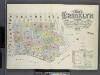
Insurance maps of the borough of Brooklyn city of New York. V.1. Published by the Sanborn Map Co., 11 Broadway, New York. 1886.
From Atlas 63. Vol. 1, 1886.
Area District Map Section No. 16
from Area district map / City of New York, Board of Estimate and Apportionment.
Use District Map Section No. 16
from Use district map / City of New York, Board of Estimate and Apportionment.
Jersey City, V. 1, Double Page Plate No. 24 [Map bounded by Ocean Ave., Linden Ave., Morris Canal, Avenue C] / compiled under the direction of and published by G.M. Hopkins Co.
From V. 1
Plan of the city of New York in North America : surveyed in the years 1766 & 1767 / B. Ratzer, lieutt. in His Majestys 60th or Royal American Regt. ; Thos. Kitchin, sculpt., engraver to His Late Royal Highness, the Duke of York, &c.
From Manhattan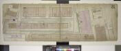
Double Page Plate No. 8; [Map bounded by Hamilton Ave., Bowne St., Imlay St., Commerce St., Ewen St., Ferris St.; Including Wolcott St., Sullivan St., King St., North Pier St., South Pier St.]
from Insurance maps of the warehouses, &c., in Brooklyn from the Navy yard to Partition Street.
Plan of the town of Brooklyn and part of Long Island.
From Brooklyn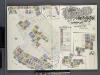
Insurance Maps of Brooklyn New York Sanborn Perris map co. 113, Broadway, New York. Volume "A" 1893.
From Atlas 61. Vol. A, 1893.
Plan of the city of New York in North America : surveyed in the years 1766 & 1767 / B. Ratzer, lieutt. in His Majestys 60th or Royal American Regt. ; Thos. Kitchin, sculpt., engraver to His Late Royal Highness, the Duke of York, &c.
from Charts and maps
South Brooklyn, Park Slope, Brooklyn heights, Cobble Hill, Boerum Hill, Carroll Gardens, Red Hook, Gowanus, Windsor Terrace. (cont.)
From District 6
Plan of the city of New York in North America : surveyed in the years 1766 & 1767 / B. Ratzer, lieutt. in His Majestys 60th or Royal American Regt. ; Thos. Kitchin, sculpt., engraver to His Late Royal Highness, the Duke of York, &c.
from Manhattan
Map of the city of New York : with the adjacent cities of Brooklyn & Jersey City, & the village of Williamsburg / drawn & engraved by John M. Atwood, 145 Fulton St., N.Y.
from Manhattan
Lower Manhattan, The Battery, Wall Street, Civic Center, Governor's Island.
From District 1
Topographical map of the city of Brooklyn as reduced from the original maps on file showing farm lines, modern improvements, etc.
From Brooklyn
Jersey City
1 : 24000
Jersey City
1 : 24000
Jersey City
1 : 24000
Jersey City
1 : 24000
Jersey City
1 : 24000