Maps of Kings County
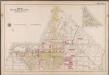
Plate 3: [Bounded by (Greenwood Cemetery) 37th Street, Fort Hamilton Avenue, West Street, 16th Avenue, 43rd Street & 9th Avenue.]; Atlas of the borough of Brooklyn, city of New York: from actual surveys and official plans by George W. and Walter S. Bromley.
from Atlas of the borough of Brooklyn, city of New York : from actual surveys and official plans by George W. and Walter S. Bromley. G.W. Bromley & Co.,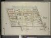
Brooklyn, Vol. 5, Double Page Plate No. 24; Part of Ward 29, Section 16; [Map bounded by Ocean Parkway, Church Lane, West St., Fort Hamilton Ave.; Including Gravesend Ave., Greenwood Ave., Prospect Ave.]
from Ward 29 and part of 32.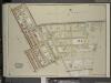
Brooklyn, Vol. 5, Double Page Plate No. 30; Part of Ward 29, Section 16; [Map bounded by 37th Ave. (Franklin Blvd.), West St., 14th Ave., 36th St.; Including 13th Ave., 14th St., 39th St.]
from Ward 29 and part of 32.
Brooklyn Vol. A Plate No. 61 [Map bounded by Greenwood Ave., Prospect Ave., Fort hamilton Ave., Gravesend Ave.]
From Atlas 61. Vol. A, 1893.
Plate 13: [Bounded by West Street, Sixteenth Avenue, 43rd Street, Ninth Avenue, 37th Street (Greenwood Cemetery) and Fort Hamilton Avenue.]
from Robinson's atlas of Kings County, New York : compiled from official records ... / under the direction of E. Robinson.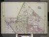
Brooklyn, Vol. 2, Double Page Plate No. 12; Part of Wards 29 & 30, Section 16 & 17; [Map bounded by West St., 16th Ave., 45th St., 9th Ave.; Including 37th St., Forthamilton Ave.] / by and under the direction of Hugo Ullitz.
From Volume 2.
Part of Wards 29 & 30, Land Map Sections, Nos. 3, 16 & 17, Volume 2, Brooklyn Borough, New York City.
from Atlas of the Brooklyn borough of the City of New York : originally Kings Co.; complete in three volumes ... based upon official maps and plans ... / by and under the supervision of Hugo Ullitz, C.E.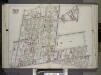
Brooklyn, Vol. 2, Double Page Plate No. 11; Part of Wards 22 & 29, Section 16; [Map bounded by Terace PL., Prospect Park South West, Coney Island Ave., Parkside Ave., Parade PL., E. 17th St.; Including E. 18th St., Albemarle Road, Church Ave., West A...
From Volume 2.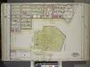
Brooklyn, Vol. 1, Double Page Plate No. 11; Part of Wards 8, 22, 29 & 30, Section 3; [Map bounded by Prospect Ave., 11th Ave., Terrace Pl., Gravesend Ave., 20th St.; Including 7th Ave., 23rd St., 6th Ave., 24th St., 5th Ave.]; and [Map bounded by 36th...
From Volume 1
Double Page Plate No. 11: [Bounded by Prospect Avenue, Eleventh Avenue, Terrace Place, Gravesend Avenue, Fort Hamilton Avenue, Thirty Seventh Street, Ninth Avenue, Thirty Ninth Street and Fifth Avenue.]
from Atlas of the Brooklyn borough of the City of New York : originally Kings Co.; complete in three volumes ... based upon official maps and plans ... / by and under the supervision of Hugo Ullitz, C.E.
Part of the Town of Flatbush, Kings Co., N.Y.
from Robinson's atlas of Kings County, New York : compiled from official records ... / under the direction of E. Robinson.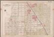
Plate 4: [Bounded by 43rd Street, 14th Avenue, 38th Street, 7th Avenue, 50th Street & 8th Avenue.]; Atlas of the borough of Brooklyn, city of New York: from actual surveys and official plans by George W. and Walter S. Bromley.
from Atlas of the borough of Brooklyn, city of New York : from actual surveys and official plans by George W. and Walter S. Bromley. G.W. Bromley & Co.,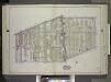
Brooklyn, Vol. 2, Double Page Plate No. 10; Part of Ward 29, Section 16; [Map bounded by Church Ave., Albemarle Road; Including E. 17th St., Cortelyou Road, West St.] / by and under the direction of Hugo Ullitz.
From Volume 2.
Green-Wood Cemetery.
1 : 3840 Anonymous
Part of Wards 22 & 29. Land Map Section, No. 16. Volume 2, Brooklyn Borough, New York City.
from Atlas of the Brooklyn borough of the City of New York : originally Kings Co.; complete in three volumes ... based upon official maps and plans ... / by and under the supervision of Hugo Ullitz, C.E.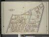
Brooklyn, Vol. 5, Double Page Plate No. 23; Part of Wards 22 & 29, Section 16; [Map bounded by 11th Ave., Coney Island Ave.; Including Greewood Ave., Gravesend Ave.]
from Ward 29 and part of 32.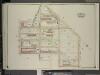
Brooklyn, Vol. 5, Double Page Plate No. 29; Part of Ward 29, Section 16; [Map bounded by West St., 16th Ave., 43rd St., 42nd St.; Including 41st St., 13th Ave., 36th St., Church Lane]
from Ward 29 and part of 32.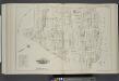
Vol. 4. Plate, I. [Map bound by Ninth Ave., Prospect Park, City Line, Greenwood Cemetery; Including Howard Pl., Fuller Pl., Tenth Ave., Eleventh Ave., Twenty-Second St., Twenty-First St., Nineteenth St., Eighteenth St., Seventeenth St., Prospect Ave., Sh
from Detailed estate and old farm line atlas of the city of Brooklyn : complete in six volumes ... from official records, private plans, and actual surveys ... / by G.M. Hopkins, C.E.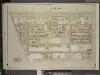
Brooklyn, Vol. 5, Double Page Plate No. 28; Part of Ward 29, Section 16; [Map bounded by Ocean Parkway, Ditmas Ave.; Including West St., Church Lane]
from Ward 29 and part of 32.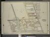
Brooklyn, Vol. 5, Double Page Plate No. 22; Part of Ward 29, Section 16; [Map bounded by Rugby Road (E. 14th St.), Albemarle Road (Avenue A), Church Ave., Church Lane, Ocean Parkway; Including Prospect Ave., Greenwood Ave., Parkside Ave., Cone
from Ward 29 and part of 32.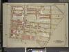
Brooklyn, Vol. 1, Double Page Plate No. 26; Part of Wards 22 & 29, Sections 3, 4 & 16; [Map bounded by 15th St., Coney Island Road, Old City Line, 11th Ave.; Including Terrace PL., Gravesend Ave., 12th St., 8th Ave.]
from Wards 1, 2, 3, 4, 5, 6, 8, 9, 10, 12 & 22.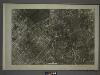
22B - N.Y. City (Aerial Set).
from Sectional aerial maps of the City of New York / [photographed and assembled under the direction of the chief engineer, July 1st, 1924].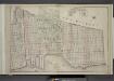
Brooklyn, Double Page Section 6; [Including Wards 8, 22]
from Farm line map of the city of Brooklyn, from official records and surveys; comp. and drawn by Henry Fulton.
Plan of the city of Brooklyn, L.I. / by William Perris.
from Brooklyn
Brooklyn, Section 10; [Including Ward 22]
from Farm line map of the city of Brooklyn, from official records and surveys; comp. and drawn by Henry Fulton.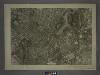
16D - N.Y. City (Aerial Set).
from Sectional aerial maps of the City of New York / [photographed and assembled under the direction of the chief engineer, July 1st, 1924].
Plate 17: Part of Ward 8 City of Brooklyn.
from Atlas of the entire city of Brooklyn, complete in one volume. From actual surveys and official records by G. W. Bromley & Co.
[Sheet 1: Map encompassing Sunset Park, Greenwood Cemetery, Gowanus Canal and Greenwood Heights.]
from Map of the city of Brooklyn : being the former cities of Brooklyn & Williamsburgh and the town of Bushwick, as consolidated January 1st, 1855 by an act of the legislature of the State of New York ... showing also a part of the City of New York.
Green-wood cemetery / surveyed by Edwd. Boyle C.E.
from Brooklyn
![Plate 3: [Bounded by (Greenwood Cemetery) 37th Street, Fort Hamilton Avenue, West Street, 16th Avenue, 43rd Street & 9th Avenue.]; Atlas of the borough of Brooklyn, city of New York: from actual surveys and official plans by George W. and Walter S. Bromley.](https://images-2.georeferencer.com/images/iiif/337888640120/full/,300/0/native.jpg)

