Maps of Manhattan Community Board 9
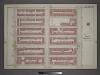
[Plate 25: Bounded by W. 139th Street, Lenox Avenue, W. 133rd Street and Eighth Avenue.]
from Atlas of the city of New York, borough of Manhattan / from actual surveys and official plans by George W. and Walter S. Bromley.
Part of Section 7: Plate 151
from Atlas of the borough of Manhattan, city of New York.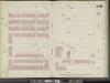
Manhattan, V. 11, Double Page Plate No. 248 [Map bounded by W. 140th St., Lenox Ave., W.. 135th St., 8th Ave.]
From Atlas 42.61. Vol. 11-11 1/2, 1893.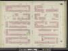
Manhattan, V. 11, Double Page Plate No. 241 [Map bounded by W. 135th St., Lenox Ave., W. 130th St., 8th Ave.]
From Atlas 42.61. Vol. 11-11 1/2, 1893.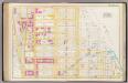
Pl. 42: ward 12.
1 : 1800 Bromley, George Washington; Bromley, Walter Scott
Plate 42: Bounded by W. 147th Street, Hudson River, Madison Avenue, W. 136th Street, and Avenue St. Nicholas.
from Atlas of the city of New York, Manhattan Island. From actual surveys and official plans / by George W. and Walter S. Bromley.
Part of Sections 6 & 7 : New York City.
from Atlas of the city of New York, borough of Manhattan. From actual surveys and official plans / by George W. and Walter S. Bromley.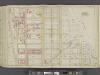
Manhattan, Double Page Plate No. 42 [Map bounded by W. 147th St., Harlem River, W. 136th St., Avenue St.]
From Atlas of the city of New York, Manhattan Island. From actual surveys and official plans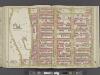
Manhattan, Double Page Plate No. 40 [Map bounded by W. 136th St., 5th Ave., W. 125th St., Convent Ave.]
From Atlas of the city of New York, Manhattan Island. From actual surveys and official plans
Plate 40: Bounded by W. 136th Street, Fifth Avenue, W. 125th Street, and Convent Avenue.
from Atlas of the city of New York, Manhattan Island. From actual surveys and official plans / by George W. and Walter S. Bromley.
[Plate 40: Bounded by W. 136th Street, Fifth Avenue, W. 125th Street, and Morningside Avenue.]
from Atlas of the city of New York, borough of Manhattan. From actual surveys and official plans / by George W. and Walter S. Bromley.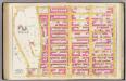
Pl. 40: ward 12.
1 : 1800 Bromley, George Washington; Bromley, Walter Scott
Plate 155: Bounded by W. 145th Street, Lenox Avenue, W. 139th Street and Eighth Avenue.
from Atlas of the borough of Manhattan, city of New York.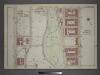
Plate 26: Part of Section 7.
from Atlas of the city of New York, borough of Manhattan / from actual surveys and official plans by George W. and Walter S. Bromley.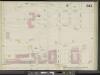
Manhattan, V. 11, Double Page Plate No. 242 [Map bounded by Convent Ave., W. 138th St., 8th Ave., W. 130th St.]
From Atlas 42.61. Vol. 11-11 1/2, 1893.
Plate 146: Bounded by W. 133rd Street, Lenox Avenue, W. 127th Street and Eighth Avenue.
from Atlas of the borough of Manhattan, city of New York.
Plate 21: Part of Section 7.
from Atlas of the city of New York, borough of Manhattan / from actual surveys and official plans by George W. and Walter S. Bromley.
Part of Section 7: Plate 150
from Atlas of the borough of Manhattan, city of New York.
Plate 30: Part of Section 7.
from Atlas of the city of New York, borough of Manhattan / from actual surveys and official plans by George W. and Walter S. Bromley.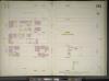
Manhattan, V. 11, Double Page Plate No. 251 [Map bounded by W. 145th St., Lenox Ave., W. 140th St., 8th Ave.]
From Atlas 42.61. Vol. 11-11 1/2, 1893.
Plate 154: Bounded by W. 145th Street, Eighth Avenue, W. 139th Street, (St. Nicholas Park, College of the City of New York) and Amsterdam Avenue.
from Atlas of the borough of Manhattan, city of New York.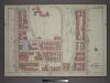
Plate 20: Part of Section 7.
from Atlas of the city of New York, borough of Manhattan / from actual surveys and official plans by George W. and Walter S. Bromley.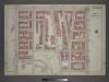
Plate 29: Part of Section 7.
from Atlas of the city of New York, borough of Manhattan / from actual surveys and official plans by George W. and Walter S. Bromley.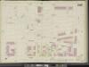
Manhattan, V. 11, Double Page Plate No. 247 [Map bounded by Convent Ave., W. 145th St., 8th Ave., W. 138th St.]
From Atlas 42.61. Vol. 11-11 1/2, 1893.
Part of Section 7: Plate 145
from Atlas of the borough of Manhattan, city of New York.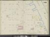
Manhattan, V. 11, Double Page Plate No. 249 [Map bounded by W. 140th St., E. 140th St., Harlem River, E. 135th St., W. 135th St., Lenox Ave.]
From Atlas 42.61. Vol. 11-11 1/2, 1893.
Manhattan, V. 11, Double Page Plate No. 240 [Map bounded by W. 135th St., E. 135th St., Madison Ave., E. 130th St., W. 130th St., Lenox Ave.]
From Atlas 42.61. Vol. 11-11 1/2, 1893.
Manhattan, V. 11, Plate No. 42 [Map bounded by 7th Ave., W. 145th St., Lenox Ave., W. 142nd St.]
From Atlas 126. Vol. 11, pt. 1, 1909.
Manhattan, V. 7, Plate No. 58 [Map bounded by W. 130th St., 7th Ave., W. 125th St., 8th Ave.]
From Atlas 120. Vol. 7, 1902.
![[Plate 25: Bounded by W. 139th Street, Lenox Avenue, W. 133rd Street and Eighth Avenue.]](https://images-2.georeferencer.com/images/iiif/528070217643/full/,300/0/native.jpg)

