Maps of Bergen County
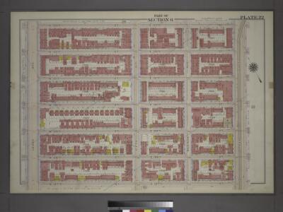
Plate 22: Part of Section 6.
from Atlas of the city of New York, borough of Manhattan / from actual surveys and official plans by George W. and Walter S. Bromley.
Plate 147: Bounded by W. 133rd Street, E. 133rd Street, Park Avenue, E. 127th Street, W. 127th Street and Lenox Avenue.
from Atlas of the borough of Manhattan, city of New York.
Manhattan, V. 11, Double Page Plate No. 240 [Map bounded by W. 135th St., E. 135th St., Madison Ave., E. 130th St., W. 130th St., Lenox Ave.]
From Atlas 42.61. Vol. 11-11 1/2, 1893.
Manhattan, V. 7, Plate No. 56 [Map bounded by W. 130th St., 5th Ave., W. 125th St., Lenox Ave.]
From Atlas 120. Vol. 7, 1902.
Manhattan, V. 7, Double Page Plate No. 29 [Map bounded by E. 134th St., Harlem River, E. 130th St., Madison Ave.] / compiled from official records and actual surveys under the direction of E. Robinson and Roger H. Pidgeon.
From Vol. 7
Manhattan, V. 8, Double Page Plate No. 178 [Map bounded by E. 130th St., 3rd Ave., E. 125th St., 5th Ave.]
From Atlas 122. Vol. 8, 1896.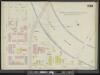
Manhattan, V. 11, Double Page Plate No. 239 [Map bounded by E. 135th St., 3rd Ave., E. 130th St., Madison Ave.]
From Atlas 42.61. Vol. 11-11 1/2, 1893.
28. Ward 12.
1 : 2400 G.W. Bromley & Co.; Geo. W. Bromley & E. Robinson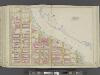
Manhattan, Double Page Plate No. 41 [Map bounded by Harlem River, E.125th St., 5th Ave.]
From Atlas of the city of New York, Manhattan Island. From actual surveys and official plans
[Plate 41: Bounded by E. 136th Street, Harlem River, First Avenue, E. 125th Street, and Fifth Avenue.]
from Atlas of the city of New York, borough of Manhattan. From actual surveys and official plans / by George W. and Walter S. Bromley.
Part of Section 6: New York City.
from Atlas of the city of New York, Manhattan Island. From actual surveys and official plans / by George W. and Walter S. Bromley.
Manhattan, Double Page Plate No. 40 [Map bounded by W. 136th St., 5th Ave., W. 125th St., Convent Ave.]
From Atlas of the city of New York, Manhattan Island. From actual surveys and official plans
[Plate 40: Bounded by W. 136th Street, Fifth Avenue, W. 125th Street, and Morningside Avenue.]
from Atlas of the city of New York, borough of Manhattan. From actual surveys and official plans / by George W. and Walter S. Bromley.
Plate 40: Bounded by W. 136th Street, Fifth Avenue, W. 125th Street, and Convent Avenue.
from Atlas of the city of New York, Manhattan Island. From actual surveys and official plans / by George W. and Walter S. Bromley.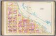
Pl. 41: ward 12.
1 : 1800 Bromley, George Washington; Bromley, Walter Scott
[Plate 152: Bounded by W. 139th Street, Fifth Avenue, E. 138th Street, (Harlem River) Madison Avenue, E. 135th Street, Park Avenue, E. 133rd Street, W. 133rd Street and Lenox Avenue.]
from Atlas of the borough of Manhattan, city of New York.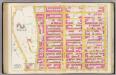
Pl. 40: ward 12.
1 : 1800 Bromley, George Washington; Bromley, Walter Scott
Part of Section 6: Plate 141
from Atlas of the borough of Manhattan, city of New York.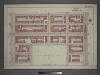
Plate 15: Part of Section 6.
from Atlas of the city of New York, borough of Manhattan / from actual surveys and official plans by George W. and Walter S. Bromley.
Plate 146: Bounded by W. 133rd Street, Lenox Avenue, W. 127th Street and Eighth Avenue.
from Atlas of the borough of Manhattan, city of New York.
Plate 21: Part of Section 7.
from Atlas of the city of New York, borough of Manhattan / from actual surveys and official plans by George W. and Walter S. Bromley.
Part of Section 6: Plate 148
from Atlas of the borough of Manhattan, city of New York.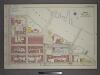
[Plate 23: Bounded by E. 133rd Street, (Harlem River) Lexington Avenue, E. 130th Street, Third Avenue, E. 129th Street, Second Avenue, E. 127th Street and Park Avenue.]
from Atlas of the city of New York, borough of Manhattan / from actual surveys and official plans by George W. and Walter S. Bromley.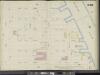
Manhattan, V. 11, Double Page Plate No. 249 [Map bounded by W. 140th St., E. 140th St., Harlem River, E. 135th St., W. 135th St., Lenox Ave.]
From Atlas 42.61. Vol. 11-11 1/2, 1893.
Part of Section 7: Plate 140
from Atlas of the borough of Manhattan, city of New York.
Plate 16: Part of Section 7.
from Atlas of the city of New York, borough of Manhattan / from actual surveys and official plans by George W. and Walter S. Bromley.
Manhattan, V. 7, Plate No. 55 [Map bounded by W. 130th St., Lenox Ave., W. 125th St., 7th Ave.]
From Atlas 120. Vol. 7, 1902.
Manhattan, V. 11, Double Page Plate No. 241 [Map bounded by W. 135th St., Lenox Ave., W. 130th St., 8th Ave.]
From Atlas 42.61. Vol. 11-11 1/2, 1893.
Manhattan, V. 8, Double Page Plate No. 174 [Map bounded by E. 125th St., 3rd Ave., E. 120th St., Portion of Mount Morris Sq., 5th Ave.]
From Atlas 122. Vol. 8, 1896.