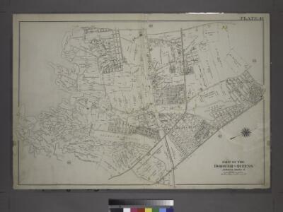
Maps of Queens County
Part of the Borough of Queens, Jamaica, Ward 4.
from Atlas of the city of New York, borough of Queens, Long Island City, Newtown, Flushing, Jamaica, Far Rockaway, from actual surveys and official plans / by George W. and Walter S. Bromley.
Queens V. 6, Plate No. 104 [Map bounded by 155th St., 159th St., Conduit]
From Atlas 142a, Vol. 6, 1911.
18D - N.Y. City (Aerial Set).
from Sectional aerial maps of the City of New York / [photographed and assembled under the direction of the chief engineer, July 1st, 1924].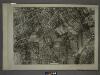
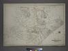
18B - N.Y. City (Aerial Set).
from Sectional aerial maps of the City of New York / [photographed and assembled under the direction of the chief engineer, July 1st, 1924].
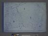
24B - N.Y. City (Aerial Set).
from Sectional aerial maps of the City of New York / [photographed and assembled under the direction of the chief engineer, July 1st, 1924].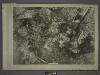
19C - N.Y. City (Aerial Set).
from Sectional aerial maps of the City of New York / [photographed and assembled under the direction of the chief engineer, July 1st, 1924].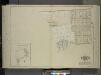
Queens, Vol. 1, Double Page Plate No. 23; Part of Ward 4; Jamaica; [Map bounded by Rockaway Plank road, Three Mile Mill Road, Old South Road; Including Smith St., Sidney St., Lewis St., Bank St., Bedford St.]; Sub Plan From Plate 17, Book 6, Pla
from Fourth and fifth wards: Jamaica and Rockaway.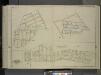
Queens, Vol. 1, Double Page Plate No. 28; Part of Ward 4; Jamaica; [Map bounded by Broadway Turnpike, Vermont Way, tennessee Way, Dakota Way, Oregon Way, Idaho Ave., Wyoming Ave., Virginia Way, Alabama Way, Nebraska Way, Florida Way; Includin
from Fourth and fifth wards: Jamaica and Rockaway.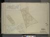
Queens, Vol. 1, Double Page Plate No. 30; Part of Ward 4; Sub Plan From Plate Nos. 18 and 19; [ Map bounded by Farmers Ave., Emerson St., Hawthorn St., 1st St., 2nd St., 3rd St., 4th St., 5th St., 6th St., 7th St.; Including New York Ave., N
from Fourth and fifth wards: Jamaica and Rockaway.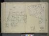
Queens, Vol. 1, Double Page Plate No. 25; Part of Ward 4; Jamaica; [Map bounded by Liberty Ave., Road to Landing, Whitelaw Ave., Arion St., Albert St., Spritz St., Old South Road, Sutter Ave., Vajen PL., Egbert PL., Dalrymple Ave., Glenmor
from Fourth and fifth wards: Jamaica and Rockaway.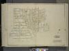
Queens, Vol. 1, Double Page Plate No. 26; Part of Ward 4; [Map bounded by Woodlawn Ave., Remsen St., New York Ave., Claude PL., Mathias St., James St., Oak St., Platt St.; Including Woodland Ave., Boyland Ave., Evergreen Ave., Fisher Ave.,
from Fourth and fifth wards: Jamaica and Rockaway.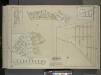
Queens, Vol. 1, Double Page Plate No. 29; Part of Ward 4; Jamaica; Sub Plan; [Map bounded by Merrick Road, Cumberland St., Carmen PL., Highview PL., Highview Ave., South St.; Including Merrick Plank Road, Hobson St., Dewey Ave., Samuel St.,
from Fourth and fifth wards: Jamaica and Rockaway.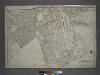
Part of the Borough of Queens, Jamaica, Ward 4.
from Atlas of the city of New York, borough of Queens, Long Island City, Newtown, Flushing, Jamaica, Far Rockaway, from actual surveys and official plans / by George W. and Walter S. Bromley.
Queens, Vol. 1, Double Page Plate No. 21; Part of Ward 4; [Map bounded by Metropolis Ave., Mill St., Vansicklen Ave., Sutter Ave., Chestnut St.; Including Metropolis Ave., Grant Ave., Rockaway Plank Road, Clinton Ave.]; Sub Plan From Plate
from Fourth and fifth wards: Jamaica and Rockaway.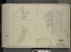
Queens, Vol. 1, Double Page Plate No. 31; Part of Ward 4; Jamaica; [Map bounded by Farmers Ave., New York Ave., Belvedere Ave., Chalfonte Ave., Road to Powells Mill, Pleasant PL.; Including 4th St., 5th St., 6th St., 7th St., 8th St., 9th St.,
from Fourth and fifth wards: Jamaica and Rockaway.
Queens V. 6, Plate No. 89 [Map bounded by 142nd St., Rockaway Blvd., Van Wyck Ave.]
From Atlas 142a, Vol. 6, 1911.
Queens V. 4, Plate No. 43 [Map bounded by Atlantic Ave., Curtis Ave., Broadway, Beech]
From Atlas 139. Vol. 4, 1901.
Jamaica
1 : 24000
Jamaica
1 : 24000
Jamaica
1 : 24000
Jamaica
1 : 24000
Jamaica
1 : 24000
Jamaica
1 : 24000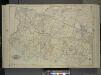
Queens, Vol. 1, Double Page Plate No. 17; Part of Ward 4; Jamaica; [Map bounded by Liberty Ave., Rockaway Turnpike, Mile Hill Road; Including Corn Fill Creek, Spring Creek]
from Fourth and fifth wards: Jamaica and Rockaway.
Key Continued
From Atlas 139. Vol. 4, 1901.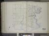
Brooklyn, Vol. 1, 2nd Part, Double Page Plate No. 50; Part of Wards 26, Section 14; [Map bounded by Vandalia Ave., Fountain Ave., Vandalia Ave.; Including Spring Creek, Jamaica Bay, Jerome St.] / by and under the direction of Hugo Ullitz.
From Volume 1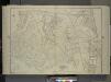
Queens, Vol. 1, Double Page Plate No. 19; Part Of Ward 4; Jamaica; [Map bounded by Conduit Long Island R.R., Boundary Line Of The City of New York; Including Hook Canal Creek, Jamaica Bay, Dead or Salt Creek.]; Sub Plan From Plate No. 17 [Map bou
from Fourth and fifth wards: Jamaica and Rockaway.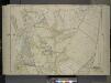
Queens, Vol. 1, Double Page Plate No. 18; Part of Ward 4; Jamaica; [Map bounded by South St., Country Road, Old Country Road, Jamaica Plank Road; Including Boundary Line Of City Of New York, Ocean Ave., Farmers Ave., Rockaway Turnpike, Th
from Fourth and fifth wards: Jamaica and Rockaway.
Height District Map Section No. 18; Height district map / City of New York, Board of Estimate and Apportionment.
from Height district map / City of New York, Board of Estimate and Apportionment. New York (N.Y.). Board of Estimate and Apportionment,
Use District Map Section No. 18; Use district map / City of New York, Board of Estimate and Apportionment.
from Use district map / City of New York, Board of Estimate and Apportionment. New York (N.Y.). Board of Estimate and Apportionment,