Maps of Kings County

Plan of the city of Brooklyn, L.I. / by William Perris.
from Brooklyn
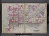
Brooklyn, Double Page Section 1; [Including wards 13, 14, 15, 16, 17, 18, 19]
from Farm line map of the city of Brooklyn, from official records and surveys; comp. and drawn by Henry Fulton.
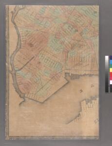
Sheet 8: Map encompassing Greenpoint and North Williamsburg.
from Map of the city of Brooklyn : being the former cities of Brooklyn & Williamsburgh and the town of Bushwick, as consolidated January 1st, 1855 by an act of the legislature of the State of New York ... showing also a part of the City of New York.
Insurance Maps of the Brooklyn city of New York Volume Four. Published by the Sanborn map co. 117, Broadway, New York. 1887.
From Atlas 74. Vol. 4, 1887.
Plan of the city of Brooklyn, L.I. / by William Perris.
from Brooklyn
Map of the City of Williamsburg and town of Bushwick, inclu. Greenpoint with part of the City of Brooklyn
From Brooklyn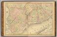
Sec. 1. Brooklyn map.
1 : 6000 Fulton, Henry; J.B. Beers & Co.
A map of the village of Williamsburgh, Kings County, N.Y. : showing each lot of ground in said village, as laid down on the assessment of the village, together with the assessment number of each lot / made by Isaac [V]ieth, under the supervision of Henry
from Brooklyn
Plan of the city of Brooklyn, L.I. / by William Perris.
from Brooklyn
13A - N.Y. City (Aerial Set).
from Sectional aerial maps of the City of New York / [photographed and assembled under the direction of the chief engineer, July 1st, 1924].
12B - N.Y. City (Aerial Set).
from Sectional aerial maps of the City of New York / [photographed and assembled under the direction of the chief engineer, July 1st, 1924].
Map of the city of New-York extending northward to Fiftieth St. / surveyed and drawn by John F. Harrison, C.E.
from Manhattan
Map showing the old high water lines along the shores of Brooklyn & New York together the the pier lines as established by law.
From Manhattan
New map of that part of the city of New York south from 20th Street on the Hudson & 35th Street on the East River : showing the position of Greenwich, Washington and West Streets on the Hudson River, and Pearl, Water, Front, Cherry & Tompkins Sts. on the
from Manhattan
Plan of the city of Brooklyn, L.I. / by William Perris.
from Brooklyn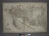
[Plate 1: Bounded by (East River) River Street, Dock Street, Front Street, Hunterspoint Avenue, West Avenue, Vernon Avenue, Freeman Avenue, Jackson Avenue, Thomson Avenue, Upton Street, Mott Avenue, Creek Street, Borden Avenue, Vernon and Flushing Street
from Atlas of the city of New York, borough of Queens, Long Island City, Newtown, Flushing, Jamaica, Far Rockaway, from actual surveys and official plans / by George W. and Walter S. Bromley.
Key
From Atlas 110. Vol. 2, 1903.
Plan of the city of Brooklyn, L.I. / by William Perris.
from Brooklyn
Part of Long Island City, Ward No. 1 & 3.
from Atlas of Queens Co., Long Island, New York / compiled from official records, private plans & actual surveys by and under the direction of Chester Wolverton.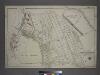
Part of the Borough of Queens, Long Island City, Ward 1.
from Atlas of the city of New York, borough of Queens, Long Island City, Newtown, Flushing, Jamaica, Far Rockaway, from actual surveys and official plans / by George W. and Walter S. Bromley.
Sheet 8: [Bounded by 20th Street, Delancy Slip, Tompkins Street, Rivington Street and Avenue A.]
from Plan of New York City, from the Battery to Spuyten Duyvil Creek. Showing every lot and building thereon; old farm lines, strreet numbers at the corners of blocks, railroads, steamboat landings, bulkhead and pier lines, etc. Based on the surveys made by Messrs. Randall & Blackwell, and on the special survey by J. F. Harrison.
Part of Section 2 : Plate 26
from Atlas of the borough of Manhattan, city of New York.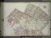
Brooklyn, Vol. 1, 2nd Part, Double Page Plate No. 33; Part of Wards 14, 15, 17, Section 8-9; [Map bounded by Meserole Ave., Jewel St., Nasau Ave., Humboldt St., Meeker Ave., Richardson St.; Including Union Ave., N. 9th St., East River, Greenpoint Ave....
From Volume 1, part 2
Part of Wards 14, 15 & 17. Land Map Sections, No. 8 & 9, Volume 1, Brooklyn Borough, New York City.
from Atlas of the Brooklyn borough of the City of New York : originally Kings Co.; complete in three volumes ... based upon official maps and plans ... / by and under the supervision of Hugo Ullitz, C.E.
Sheet 10: [Bounded by E. Fortieth Street, First Avenue, E. Twentieth Street and Sixth Avenue.]
from Plan of New York City, from the Battery to Spuyten Duyvil Creek. Showing every lot and building thereon; old farm lines, strreet numbers at the corners of blocks, railroads, steamboat landings, bulkhead and pier lines, etc. Based on the surveys made by Messrs. Randall & Blackwell, and on the special survey by J. F. Harrison.
Part of Wards 13 & 14. Land Map Section, No. 8, Volume 1, Brooklyn Borough, New York City.
from Atlas of the Brooklyn borough of the City of New York : originally Kings Co.; complete in three volumes ... based upon official maps and plans ... / by and under the supervision of Hugo Ullitz, C.E.
Double Page Plate No. 32: [Bounded by Marcy Ave., Metropolitan Ave., N. Fifth St., Havemeyer St., Withers St., Union Ave., Richardson St., Leonard St., Frost St., Manhattan Ave., Withers St., Graham Ave., Jackson St., Humboldt St., Metropolitan Ave., Bus
from Atlas of the Brooklyn borough of the City of New York : originally Kings Co.; complete in three volumes ... based upon official maps and plans ... / by and under the supervision of Hugo Ullitz, C.E.
Part of Wards 17 & 18. Land Map Sections, No. 9 & 10, Volume 1, Brooklyn Borough, New York City.
from Atlas of the Brooklyn borough of the City of New York : originally Kings Co.; complete in three volumes ... based upon official maps and plans ... / by and under the supervision of Hugo Ullitz, C.E.
Page 4: [Bounded by Luise Street (Kips Bay), East River, (Stuyvesant Square) E. Thirteenth Street, Third Avenue, Irving Place (Union Square) and Broadway.]
from Sackersdorf Farm Set.