Maps of Richmond County

Section 23
from Atlas of Staten Island, Richmond County, New York, from official records and surveys; compiled and drawn by F. W. Beers.
Part of Ward 5. [Map bound by Arthur Kill Road, Rossville Ave, Woodrow Road, Foster Road (Rossville Ave), Ramona Ave, Maguire Ave, Sandy Brook, Rossville Road, Pleasant Ave]
from Atlas of the city of New York, borough of Richmond, Staten Island. From actual surveys and original plans, by George W. and Walter S. Bromley.
Sheet No. 88. [Includes Ploughshare Point, Fresh Kills Road (Arthur Kill Road) and (Charleston) Allentown Lane.]; Borough of Richmond, Topographical Survey.
from Borough of Richmond, Topographical Survey. Staten Island. Topographical Bureau.,
Sheet No. 89. [includes Allentown Lane(Charleston), Pleasant Plains Avenue, Bloomingdale Avenue and (Seguine Avenue) Seguine Road in Pleasant Plains.]; Borough of Richmond, Topographical Survey.
from Borough of Richmond, Topographical Survey. Staten Island. Topographical Bureau.,
Sheet No. 94. [Includes Richmond Valley, Mount Loretto and Pleasant Plains.]; Borough of Richmond, Topographical Survey.
from Borough of Richmond, Topographical Survey. Staten Island. Topographical Bureau.,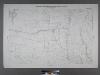
Sheet No. 82. [Includes Sharrotts Road, Pleasant Avenue and Kaolin Avenue in Woodrow.]; Borough of Richmond, Topographical Survey.
from Borough of Richmond, Topographical Survey. Staten Island. Topographical Bureau.,
33A - N.Y. City (Aerial Set).
from Sectional aerial maps of the City of New York / [photographed and assembled under the direction of the chief engineer, July 1st, 1924].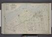
Part of Ward 5. [Map bound by State Boundary Line, Hugenot Ave, Wood Row Road, Sharrotts Road; Morris St, Totten St, Cleveland St, Rossville Ave]
from Atlas of the borough of Richmond, city of New York.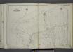
Part of Ward 5. [Map bound by Arthur Kill or Staten Island Sound, Arthur Kill Road (Fresh Kills RD), Pleasant Ave, Guyon Ave, Clay Pit Road, Winant PL, Sharrotts Road, Ellis Road]
from Atlas of the city of New York, borough of Richmond, Staten Island. From actual surveys and original plans, by George W. and Walter S. Bromley.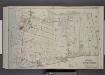
Part of Ward 5. [Map bound by Sharrotts Road, Shore Road, Wood Row Road, Foster or Rossville Ave, Amboy Road, The Staten Island Railway Co., Pier & Bulkhead Line]
from Atlas of the borough of Richmond, city of New York.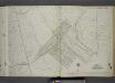
Part of Ward 5. [Map bound by Arthur Kill Road (Fresh Kills RD), Arden Ave (Washington), Carneaux Ave, Carlton Boulevard, Woodrow (Journeay) (Jessups Lane) (Greenridge Ave), Annadale Road, Forest Ave, Detroit Ave, Ramona Ave, Jefferson Boulevar
from Atlas of the city of New York, borough of Richmond, Staten Island. From actual surveys and original plans, by George W. and Walter S. Bromley.
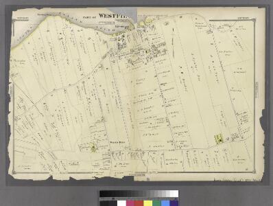
Part of Westfield.
from Atlas of Staten Island, Richmond County, New York, from official records and surveys; compiled and drawn by F. W. Beers.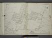
Part of Ward 5. [Map bound by Maguire Ave, Ramona Ave, Lamont Ave, Ionia Ave, Edgegrove Ave, Detroit Ave, Huguenot Ave, Thompson St, Cottage Ave, Staten Island Rail Road, Amboy Road, Seguine Ave, Wood Ave (Elmer Ave), Bay View Ave]
from Atlas of the city of New York, borough of Richmond, Staten Island. From actual surveys and original plans, by George W. and Walter S. Bromley.
Part of Westfield.
from Atlas of Staten Island, Richmond County, New York, from official records and surveys; compiled and drawn by F. W. Beers.
Section 18
from Atlas of Staten Island, Richmond County, New York, from official records and surveys; compiled and drawn by F. W. Beers.
Height District Map Section No. 33
from Height district map / City of New York, Board of Estimate and Apportionment.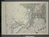
General map of the borough of Richmond (Staten Island) in the city of New York : showing in addition to the existing topographical features of the borough a tentative and preliminary plan for a street system of the same.
from Staten Island
Arthur Kill
1 : 24000
Arthur Kill
1 : 24000
Arthur Kill
1 : 24000
Arthur Kill
1 : 24000
Arthur Kill
1 : 24000
Arthur Kill
1 : 24000
Arthur Kill
1 : 24000
Use District Map Section No. 33; Use district map / City of New York, Board of Estimate and Apportionment.
from Use district map / City of New York, Board of Estimate and Apportionment. New York (N.Y.). Board of Estimate and Apportionment,
Area District Map Section No. 33; Area district map / City of New York, Board of Estimate and Apportionment.
from Area district map / City of New York, Board of Estimate and Apportionment. New York (N.Y.). Board of Estimate and Apportionment,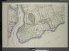
General map of the borough of Richmond (Staten Island) in the city of New York : showing in addition to the existing topographical features of the borough a tentative and preliminary plan for a street system of the same.
from Staten Island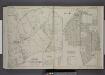
Part of Ward 5. [Map bound by Huguenot Ave, Fresh Kills Road, Bridge Ave, Staten Island Rapid Transit, Amboy Road, Foster or Rossville Ave, Wood Row Road; Sub Plan A - Annadale Road, Moffatt St, Washington Ave; Richmond ( Part of Wards 3 & 4
from Atlas of the borough of Richmond, city of New York.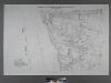
Sheet No. 81. [Includes Sharrotts Road, Kreischerville (Port Mobil).]
from Borough of Richmond, Topographical Survey.