Maps of Richmond County
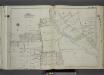
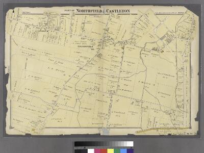
Part of Northfield & Castleton.
from Atlas of Staten Island, Richmond County, New York, from official records and surveys; compiled and drawn by F. W. Beers.
Part of Wards 1 & 3. [Map bound by Washington Ave, Richmond Road, Decker Ave, Barrett Ave, Cherry Lane, Jewett Ave, Richmond Turnpike, Neptune PL, Richmond Road, Merrill Ave, Lamberts Lane]
from Atlas of the borough of Richmond, city of New York.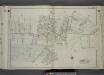
Part of Wards 1 & 3. [Map bound by Union Ave, Maple Ave, Van Pelt Ave, Van Name Ave, Simonson Ave, Forest Ave (Cherry Lane), Dixon Ave (Barnes Ave), Morning Star Road, Richmond Ave (Old Stone Road) (Port Richmond Road), Seymour Ave, Decker
from Atlas of the city of New York, borough of Richmond, Staten Island. From actual surveys and original plans, by George W. and Walter S. Bromley.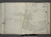
Part of Ward 3. [Map bound by Attorney St, Essex St, Lambert St, Center St, Spring St, De Puy St (Columbia Ave), Richmond Ave (Old Stone Road), Deppe PL, Morris St, Franklin St, Houston St, Watchogue Road, Willow Brook Road (Gun Factory RD),
from Atlas of the city of New York, borough of Richmond, Staten Island. From actual surveys and original plans, by George W. and Walter S. Bromley.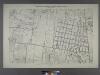
Borough of Richmond, Topographical Survey.
from Borough of Richmond, Topographical Survey.
Borough of Richmond, Topographical Survey.
from Borough of Richmond, Topographical Survey.
Borough of Richmond, Topographical Survey.
from Borough of Richmond, Topographical Survey.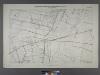
Sheet No. 29. [Includes Bulls Head, from Merrill Avenue to Richmond Turnpike.]; Borough of Richmond, Topographical Survey.
from Borough of Richmond, Topographical Survey. Staten Island. Topographical Bureau.,
Staten Island, V. 2, Plate No. 144 [Map bounded by College Ave., Jewett Ave., Dakota Pl., Watchogue Rd., Livermore Ave.]
From Atlas 163.1. Vol. 2, 1917.
Staten Island, V. 2, Plate No. 136 [Map bounded by Creek, Jewett Ave., College Ave., Marianne ]
From Atlas 163.1. Vol. 2, 1917.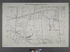
Sheet No. 30. [Includes Auburn Avenue, Willow Brook Road, Decatur Avenue, Stewart Avenue, Sheridan Avenue and Wheeler Avenue in Willow Brook.]; Borough of Richmond, Topographical Survey.
from Borough of Richmond, Topographical Survey. Staten Island. Topographical Bureau.,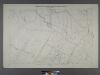
Sheet No. 38. [Includes Port Richmond Road, Manor Road, Bradley Avenue and Gun Factory Road.]; Borough of Richmond, Topographical Survey.
from Borough of Richmond, Topographical Survey. Staten Island. Topographical Bureau.,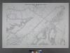
Sheet No. 36. [Includes Chelsea Avenue, Union Avenue, Chelsea Creek, Richmond Turnpike and (Travis) Linoleum Ville.]; Borough of Richmond, Topographical Survey.
from Borough of Richmond, Topographical Survey. Staten Island. Topographical Bureau.,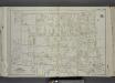
Part of Ward 3. [Map bound by Richmond Ave, Albion PL, Washington PL, Simonson PL, Catharine St, Jewett Ave, Post Ave, Courtland St (Madison Ave), Catharine St, Palmers Run, Barrett Ave, Decker Ave, Riley PL, John St]
from Atlas of the city of New York, borough of Richmond, Staten Island. From actual surveys and original plans, by George W. and Walter S. Bromley.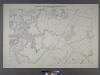
Sheet No. 28. [Includes Bloomfield, (Staten Island Wet Lands Preserve), (Bulls Head) and South Avenue.]; Borough of Richmond, Topographical Survey.
from Borough of Richmond, Topographical Survey. Staten Island. Topographical Bureau.,
Staten Island, V. 2, Plate No. 131 [Map bounded by Harbor Rd., Summerfield Ave., South Ave.]
From Atlas 163.1. Vol. 2, 1917.
Staten Island, V. 2, Plate No. 137 [Map bounded by Forest Ave., Delaware Pl., Maine, Jewett Ave.]
From Atlas 163.1. Vol. 2, 1917.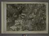
20D - N.Y. City (Aerial Set).
from Sectional aerial maps of the City of New York / [photographed and assembled under the direction of the chief engineer, July 1st, 1924].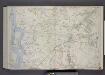
Part of Wards 2 & 3. [Map bound by Old Place Creek, Washington Ave, Lisk Ave, Lamberts Lane, Merrill Ave, Richmond Road, Richmond Turnpike, Willow Brook Road, New Road, Jones or Rockland Ave, Old Shore Road, Union Ave, Lexington Ave, Cannon Av
from Atlas of the borough of Richmond, city of New York.
Village of Port Richmond.
from Atlas of Staten Island, Richmond County, New York, from official records and surveys; compiled and drawn by F. W. Beers.
Section 11.
from Atlas of Staten Island, Richmond County, New York, from official records and surveys; compiled and drawn by F. W. Beers.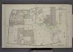
Part of Ward 1. [Map bound by Cherry Lane, Forest Ave, Lowell Ave, Davis Ave, Pelton Ave, Bard Ave, Glove Road, Richmond Turnpike, Jewett Ave]
from Atlas of the borough of Richmond, city of New York.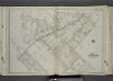
Part of Ward 1. [Map bound by Palmers Run, Spring St, Post Ave, Greenleaf Ave, Forest Ave (Cherry Lane), Brookside Ave, Egbert Ave, Manor Road, Kingsley Ave (New York Ave), New York PL, Maine Ave, Jewett Ave, College Ave (Indiana Ave)]
from Atlas of the city of New York, borough of Richmond, Staten Island. From actual surveys and original plans, by George W. and Walter S. Bromley.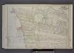
Part of Ward 3. [Map bound by Johnson Ave, Innis St, Grant St, Sherman Ave, Prospect St, Richmond Ave, Washington Ave, Van Pelt Ave, Pier & Bulkhead Line 1881]
from Atlas of the borough of Richmond, city of New York.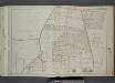
Part of Wards 1, 2 & 3. [Map bound by Forest Hill Road (Fort Richmond), Willow Brook Road (Gun Factory RD), Caswell Ave, Harvey Ave, Marble St, Byrne Ave, Buchanan Ave, Delmont St, Cedar Ave, Washington Ave, Broadway]
from Atlas of the city of New York, borough of Richmond, Staten Island. From actual surveys and original plans, by George W. and Walter S. Bromley.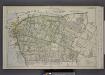
Part of Wards 1 & 3. [Map bound by Palmer's Run, Jewett Ave, Cherry Lane, Barrett Ave, Decker Ave, Richmond Ave, Prospect St, Grant St, Johnson Ave, Kill Van Kull]
from Atlas of the borough of Richmond, city of New York.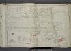
Part of Ward 3. [Map bound by Union Ave, Staten Island Rapid Transit R.R., De Hart Ave (Central Ave), Richmond Terrace, Pierhead and Bulkhead Line, Winant St (Monroe Ave), Simonson Ave, Van Name Ave, Van Pelt Ave, Maple Ave]
from Atlas of the city of New York, borough of Richmond, Staten Island. From actual surveys and original plans, by George W. and Walter S. Bromley.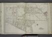
Part of Ward 3. [Map bound by Winant St (Monroe), Richmond Terrace, Pierhead & Bulkhead Line, Nicholas Ave, Castleton Ave (Hatfield), Grove PL (Woodland PL), Charles Ave, Richmond Ave, Prospect St, Morningstar Road, David PL]
from Atlas of the city of New York, borough of Richmond, Staten Island. From actual surveys and original plans, by George W. and Walter S. Bromley.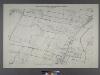
Sheet No. 21. [Includes (Graniteville) from South Avenue to Watchogue Road, and from Lisk Avenue to Kirshon Avenue.]; Borough of Richmond, Topographical Survey.
from Borough of Richmond, Topographical Survey. Staten Island. Topographical Bureau.,