Maps of Manhattan Community Board 9

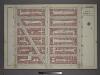
Part of Section 7: Plate 133
from Atlas of the borough of Manhattan, city of New York.
101st St. & 102nd St. and the East River.
From Manhattan
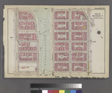
Plate 8: Part of Section 7.
from Atlas of the city of New York, borough of Manhattan / from actual surveys and official plans by George W. and Walter S. Bromley.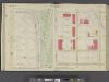
Manhattan, V. 7, Double Page Plate No. 8 [Map bounded by W. 122nd St., 8th Ave., W. 118th St., 10th Ave.] / compiled from official records and actual surveys under the direction of E. Robinson and Roger H. Pidgeon.
From Vol. 7
Manhattan, V. 7, Plate No. 45 [Map bounded by W. 120th St., 8th Ave., W. 115th St., Morningside Ave. East]
From Atlas 120. Vol. 7, 1902.
Manhattan, V. 7, Plate No. 44 [Map bounded by W. 120th St., Morningside Ave. East, W. 115th St., Amsterdam Ave.]
From Atlas 120. Vol. 7, 1902.
Manhattan, V. 7, Plate No. 51 [Map bounded by W. 125th St., 8th Ave., W. 120th St., Morningside Ave. East]
From Atlas 120. Vol. 7, 1902.
Manhattan, V. 7, Plate No. 46 [Map bounded by W. 120th St., 7th Ave., W. 115th St., 8th Ave.]
From Atlas 120. Vol. 7, 1902.
Manhattan, V. 7, Plate No. 50 [Map bounded by W. 125th St., Morningside Ave. East, W. 120th St., Amsterdam Ave.]
From Atlas 120. Vol. 7, 1902.
Manhattan, V. 7, Plate No. 43 [Map bounded by W. 120th St., Amsterdam Ave., W. 115th St., Broadway]
From Atlas 120. Vol. 7, 1902.
Manhattan, V. 7, Plate No. 36 [Map bounded by W. 115th St., Morningside Ave. West, Cathedral Parkway, Amsterdam Ave.]
From Atlas 120. Vol. 7, 1902.
Manhattan, V. 7, Plate No. 52 [Map bounded by W. 125th St., 7th Ave., W. 120th St., 8th Ave.]
From Atlas 120. Vol. 7, 1902.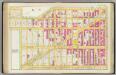
Pl. 35: ward 12.
1 : 1800 Bromley, George Washington; Bromley, Walter Scott
Preliminary Study for the Design of Morningside Park [1873].
From Manhattan
Part of Section 7: New York City.
from Atlas of the city of New York, Manhattan Island. From actual surveys and official plans / by George W. and Walter S. Bromley.
Map of Morningside Park.
From Manhattan
Part of Section 7 : New York City.
from Atlas of the city of New York, borough of Manhattan. From actual surveys and official plans / by George W. and Walter S. Bromley.
Pl. 38: ward 12.
1 : 1800 Bromley, George Washington; Bromley, Walter Scott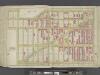
Manhattan, Double Page Plate No. 35 [Map bounded by Manhattan Morningside Ave E., W. 125th St., Lenox Ave., W. 110th St.]
From Atlas of the city of New York, Manhattan Island. From actual surveys and official plans
[Plate 38: Bounded by Hudson River (Riverside Park, Riverside Drive), W. 125th Street, Morningside Drive, Columbus Avenue, and W. 108th Street.]
from Atlas of the city of New York, borough of Manhattan. From actual surveys and official plans / by George W. and Walter S. Bromley.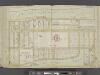
Manhattan, Double Page Plate No. 38 [Map bounded by Hudson River, W. 125th St., 9th Ave., W.1 08th St.]
From Atlas of the city of New York, Manhattan Island. From actual surveys and official plans
Plate 38: Bounded by (Hudson River) Riverside Park/Drive, W. 125th Street, 9th Avenue, W. 123rd Street, 10th Avenue, Morningside Avenue, Columbus [Avenue] and W. 108th Street.
from Atlas of the city of New York, Manhattan Island. From actual surveys and official plans / by George W. and Walter S. Bromley.
Revised general plan for Morningside Park, to accompany report by Frederick Law Olmsted and Calvert Vaux . . . September 28th, 1887.
From Manhattan
Plate 139: Bounded by Lawrence Street, W. 127th Street, Eighth Avenue, W. 122nd Street, Morningside Avenue, W. 123rd Street and Amsterdam Avenue.
from Atlas of the borough of Manhattan, city of New York.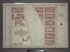
[Plate 5: Bounded by W. 116th Street, Eighth Avenue, Cathedral Parkway. and Amsterdam Avenue.]
from Atlas of the city of New York, borough of Manhattan / from actual surveys and official plans by George W. and Walter S. Bromley.
Plate 127: Bounded by W. 116th Street, Eighth Avenue, Cathedral Parkway and Amsterdam Avenue.
from Atlas of the borough of Manhattan, city of New York.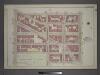
Plate 17: Part of Section 7.
from Atlas of the city of New York, borough of Manhattan / from actual surveys and official plans by George W. and Walter S. Bromley.
27. Ward 12.
1 : 2400 G.W. Bromley & Co.; Geo. W. Bromley & E. Robinson
Plate 134: Bounded by W. 122nd Street, Lenox Avenue, W. 116th Street, and Eighth Avenue.
from Atlas of the borough of Manhattan, city of New York.