Maps of Bergen County

[Plate 176: Bounded by Northern Avenue, Wadsworth Avenue, W. 188th Street and (Hudson River) Riverside Drive.]
from Atlas of the borough of Manhattan, city of New York.
Manhattan, V. 12, Plate No. 10 [Map bounded by Hudson River, Broadway]
From Atlas 128. Vol. 12, 1900.
Manhattan, V. 12, Plate No. 28 [Map bounded by Riverside Drive, Fort Washington Ave.]
From Atlas 129. Vol. 12, 1913.
Manhattan, V. 12, Plate No. 29 [Map bounded by Overlook Terr., Broadway, W. 188th St., Fort Washington Ave.]
From Atlas 129. Vol. 12, 1913.
Manhattan, V. 12, Plate No. 22 [Map bounded by Fort Wasshington Ave., W. 188th St., Broadway, W. 186th St.]
From Atlas 129. Vol. 12, 1913.
Manhattan, V. 12, Plate No. 24 [Map bounded by Broadway, W. 190th St., St. Nicholas Ave., W. 187th St.]
From Atlas 129. Vol. 12, 1913.
Manhattan, V. 12, Plate No. 35 [Map bounded by Riverside Drive, Broadway]
From Atlas 129. Vol. 12, 1913.
Manhattan, V. 12, Plate No. 30 [Map bounded by Broadway, W. 193rd St., St. Nicholas Ave.]
From Atlas 129. Vol. 12, 1913.
Manhattan, V. 12, Plate No. 21 [Map bounded by Hudson River, Fort Washington Ave.]
From Atlas 129. Vol. 12, 1913.
Manhattan, V. 12, Plate No. 38 [Map bounded by Ellwood St., W. 193rd St., Broadway]
From Atlas 129. Vol. 12, 1913.
Manhattan, V. 12, Plate No. 37 [Map bounded by Ellwood St., Nagle Ave., Broadway]
From Atlas 129. Vol. 12, 1913.
[Plate 47: Bounded by Harlem River, W. 182nd Street, W. 183rd Street, and Hudson River.]
from Atlas of the city of New York, borough of Manhattan. From actual surveys and official plans / by George W. and Walter S. Bromley.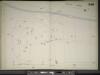
Manhattan, V. 11 1/2, Double Page Plate No. 248 [Map bounded by Hudson River, Broadway, (Un-Named) Road]
From Atlas 42.61. Vol. 11-11 1/2, 1893.
Manhattan, V. 12, Plate No. 15 [Map bounded by Hudson River, Broadway]
From Atlas 128. Vol. 12, 1900.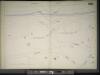
Manhattan, V. 11 1/2, Double Page Plate No. 250 [Map bounded by Hudson River, Dyckman St.]
From Atlas 42.61. Vol. 11-11 1/2, 1893.
Manhattan, V. 12, Plate No. 11 [Map bounded by Broadway, Amsterdam Ave., W. 190th St.]
From Atlas 128. Vol. 12, 1900.
Part of Section 8: Plate 174
from Atlas of the borough of Manhattan, city of New York.
[Plate 178: Bounded by Riverside Drive (Hudson River), Corbin Place, Ft. Washington Avenue, Broadway, W. 192nd Street, Overlook Terrace and Northern Avenue. ]
from Atlas of the borough of Manhattan, city of New York.
Manhattan, V. 12, Plate No. 8 [Map bounded by Broadway, W. 190th St., Amsterdam Ave., W. 186th St.]
From Atlas 128. Vol. 12, 1900.
Plate 177: Bounded by Fairview Avenue, (Isabella Heimath Home), Amsterdam Avenue (Harlem River),W. 189th Street, W. 190th Street and Wadsworth Terrace.
from Atlas of the borough of Manhattan, city of New York.
Manhattan, V. 12, Plate No. 9 [Map bounded by Hudson River, Broadway, W. 181st St.]
From Atlas 128. Vol. 12, 1900.
Part of Section 8: Plate 175
from Atlas of the borough of Manhattan, city of New York.
Plate 179: Bounded by Broadway, Sherman Avenue, Dyckman Street, St Nicholas Avenue and Fairview Avenue.
from Atlas of the borough of Manhattan, city of New York.
Manhattan, V. 12, Plate No. 16 [Map bounded by Northern Ave., Fort Washington Ave., W. 181st St.]
From Atlas 129. Vol. 12, 1913.
Manhattan, V. 12, Plate No. 23 [Map bounded by W. 187th St., St. Nicholas Ave., W. 183rd St., Broadway]
From Atlas 129. Vol. 12, 1913.
Manhattan, V. 12, Plate No. 17 [Map bounded by W. 186th St., Broadway, W. 181st St., Fort Washington Ave.]
From Atlas 129. Vol. 12, 1913.
Manhattan, V. 12, Plate No. 26 [Map bounded by St. Nicholas Ave., W. 191st St., Amsterdam Ave., W. 188th St.]
From Atlas 129. Vol. 12, 1913.
Manhattan, V. 12, Plate No. 15 [Map bounded by Hudson River, Northern Ave., W. 181st St.]
From Atlas 129. Vol. 12, 1913.
Page 24: [Bounded by 199th Street, Harlem River, 177th Street and Hudson River.]
from Sackersdorf Farm Set.
![[Plate 176: Bounded by Northern Avenue, Wadsworth Avenue, W. 188th Street and (Hudson River) Riverside Drive.]](https://images-2.georeferencer.com/images/iiif/350042076000/full/,300/0/native.jpg)

