Maps of Bronx County
Part of Ward 24, New York City.
from Atlas of the city of New York : embracing all territory within its corporate limits from official records, private plans & actual surveys / by and under the supervision of E. Robinson & R.H. Pidgeon, civil engineers.
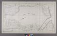
Plan for the Riverside Drive Extension from 155th Street to the Harlem River (exhibit A.)
From Manhattan
Key continued
From Atlas 128. Vol. 12, 1900.
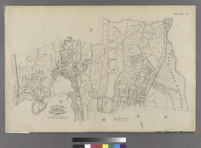
Plates 23 & 24: Southern Part of Yonkers and portion of West Farms.
from County atlas of Westchester, New York. Published by J.B. Beers & Co., assisted by S.W. Wilson and others.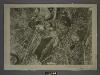
1D - N.Y. City (Aerial Set).
from Sectional aerial maps of the City of New York / [photographed and assembled under the direction of the chief engineer, July 1st, 1924].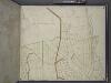
Bronx, Topographical Map Sheet 4; [Map bounded by Mosholu Ave., Jerome Ave., Bronx River, Richard St., Lorillard Terrace, Tillotson Ave., Railroad Ave., Hull Ave., Perry Ave., Bainbridge Ave., Briggs Ave., Carlin PL.; Including Marion Ave., Antony Ave...
From Topographical map made from surveys by the commissioners of the Department of Public Parks of the City of New York of that part of Westchester County adjacent to the City and County of New York embraced by chapter 534 of laws of 1871 as amended b...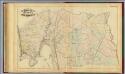
39. Ward 24.
1 : 7200 G.W. Bromley & Co.; Geo. W. Bromley & E. Robinson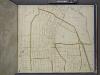
Bronx, Topographical Map Sheet 6; [Map bounded by Gambril St., Brook St., Low St., Lorilard Terrace, Bronx River, Southern Blvd., Kingsbridge, 3rd Ave., 182nd St.; Including Washington Ave., New York and Harlem Railroad, Webster Ave., Folin St., 4th ...
From Topographical map made from surveys by the commissioners of the Department of Public Parks of the City of New York of that part of Westchester County adjacent to the City and County of New York embraced by chapter 534 of laws of 1871 as amended b...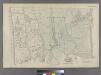
Part of Ward 24, New York City.
from Atlas of the city of New York : embracing all territory within its corporate limits from official records, private plans & actual surveys / by and under the supervision of E. Robinson & R.H. Pidgeon, civil engineers.
Bronx, Topographical Map Sheet 5; [Map bounded by Morkison St., Johnson Ave., Riverdale Ave., Ackerman St., Church St., Broadway, Macomb St., Albany Road, Bailas Ave., Heath Ave., Boston Ave., Sedgwick Ave.; Including Tee-Taw Ave., Aqueduct Ave., Hamp...
From Topographical map made from surveys by the commissioners of the Department of Public Parks of the City of New York of that part of Westchester County adjacent to the City and County of New York embraced by chapter 534 of laws of 1871 as amended b...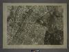
3B - N.Y. City (Aerial Set).
from Sectional aerial maps of the City of New York / [photographed and assembled under the direction of the chief engineer, July 1st, 1924].
Plates 23 & 24: Southern Part of Yonkers and portion of West Farms.
from County atlas of Westchester, New York. Published by J.B. Beers & Co., assisted by S.W. Wilson and others.
Large folder - L1
from Atlas of New York and vicinity : from actual surveys / by and under the direction of F. W. Beers, assisted by A. B. Prindle & others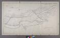
Map or Plan of Section 28. [Bounded by Southern Boulevard, E. 200th Street, Jerome Avenue, Gun Hill Road and Webster Avenue.]
from Maps or plans and profiles, with field notes and explanatory remarks, showing the location, width, grades, and class of streets, roads, avenues, public squares and places, located and laid out by the Commissioner of Street Improvements of the 23rd and 24th wards of the city of New York : under authority of Chapter 545 of the laws of 1890.
Plate 45: Bounded by Boulevard Lafayette (Hudson River), Harlem River ...
from Atlas of the city of New York, Manhattan Island. From actual surveys and official plans / by George W. and Walter S. Bromley.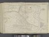
Manhattan, Double Page Plate No. 45 [Map bounded by Hudson River, Harlem River]
From Atlas of the city of New York, Manhattan Island. From actual surveys and official plans
Plate 20: Yonkers, Westchester Co. N.Y. (Spuyten Duvil.)
from Atlas of New York and vicinity : from actual surveys / by and under the direction of F. W. Beers, assisted by A. B. Prindle & others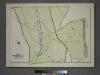
Plate 82, Part of Section 13, Borough of the Bronx. [Bounded by Broadway, Van Cortlandt Park South, Gun Hill Road, E. 211th Street, Webster Avenue, E. 233rd Street and Mt. Vernon Avenue.]
from Atlas of borough of the Bronx, Sections 9 10 11 12 & 13 : from actual surveys and official plans / G.W. Bromley and Co.
Bronx, Topographical Map Sheet 3; [Map bounded by Bates St., Riverdale Ave., Moshold Ave., Broadway, Vancortlandt Ave., Bailey Ave., Ft. Independence St.; Including Albany Road, Church Kingsbridge Ave., Webbers Lane, Ackerman St., Johnson Ave., Spuyte...
From Topographical map made from surveys by the commissioners of the Department of Public Parks of the City of New York of that part of Westchester County adjacent to the City and County of New York embraced by chapter 534 of laws of 1871 as amended b...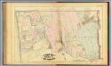
40. Ward 24.
1 : 7200 G.W. Bromley & Co.; Geo. W. Bromley & E. Robinson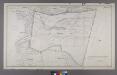
Section 27 of Final Maps and Profiles, of the 23rd & 24th Wards.
from Maps or plans and profiles, with field notes and explanatory remarks, showing the location, width, grades, and class of streets, roads, avenues, public squares and places, located and laid out by the Commissioner of Street Improvements of the 23rd and 24th wards of the city of New York : under authority of Chapter 545 of the laws of 1890.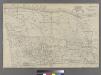
Plate 38: Bounded by Harlem River, Highbridge Road, Jerome Avenue, Primrose Street, Vanderbilt Avenue, ...
from Atlas of the city of New York : embracing all territory within its corporate limits from official records, private plans & actual surveys / by and under the supervision of E. Robinson & R.H. Pidgeon, civil engineers.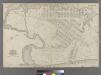
Part of Ward 12, New York City.
from Atlas of the city of New York : embracing all territory within its corporate limits from official records, private plans & actual surveys / by and under the supervision of E. Robinson & R.H. Pidgeon, civil engineers.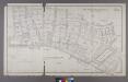
Map or Plan of Section 17. [Bounded by Walton Avenue, Fordham Road, Morris Avenue, E. 196th Street, Creston Avenue, E. 198th Street, Grand Boulevard and Concourse, E. 204th Street, Mosholu Parkway South, Bainbridge Avenue, Woodlawn Road, Webster Avenuean
from Maps or plans and profiles, with field notes and explanatory remarks, showing the location, width, grades, and class of streets, roads, avenues, public squares and places, located and laid out by the Commissioner of Street Improvements of the 23rd and 24th wards of the city of New York : under authority of Chapter 545 of the laws of 1890.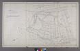
Section 22 of Final Maps and Profiles, of the 23rd & 24th Wards.
from Maps or plans and profiles, with field notes and explanatory remarks, showing the location, width, grades, and class of streets, roads, avenues, public squares and places, located and laid out by the Commissioner of Street Improvements of the 23rd and 24th wards of the city of New York : under authority of Chapter 545 of the laws of 1890.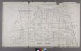
Map or Plan of Section 21. [Bounded by Riverdale Avenue, W. 238th Street, Spuyten Duvil Road, W. 240th Street, Van Cortlandt Avenue, Gun Hill Road, Sedgwick Avenue and Kingsbridge Road.]
from Maps or plans and profiles, with field notes and explanatory remarks, showing the location, width, grades, and class of streets, roads, avenues, public squares and places, located and laid out by the Commissioner of Street Improvements of the 23rd and 24th wards of the city of New York : under authority of Chapter 545 of the laws of 1890.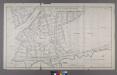
Section 18 of Final Maps and Profiles, of the 23rd & 24th Wards.
from Maps or plans and profiles, with field notes and explanatory remarks, showing the location, width, grades, and class of streets, roads, avenues, public squares and places, located and laid out by the Commissioner of Street Improvements of the 23rd and 24th wards of the city of New York : under authority of Chapter 545 of the laws of 1890.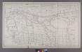
Map or Plan of Section 16. [Bounded by Burnside Avenue, Jerome Avenue, E. 184th Street, Walton Avenue, Morris Avenue and Kingsbridge Road.]
from Maps or plans and profiles, with field notes and explanatory remarks, showing the location, width, grades, and class of streets, roads, avenues, public squares and places, located and laid out by the Commissioner of Street Improvements of the 23rd and 24th wards of the city of New York : under authority of Chapter 545 of the laws of 1890.
Plates 17 & 18: Fordham, Town of West Farms, Westchester Co. N.Y.
from County atlas of Westchester, New York. Published by J.B. Beers & Co., assisted by S.W. Wilson and others.