Maps of Manhattan Community Board 9
Part of Ward 12, New York City.
from Atlas of the city of New York : embracing all territory within its corporate limits from official records, private plans & actual surveys / by and under the supervision of E. Robinson & R.H. Pidgeon, civil engineers.
Sackersdorff Farm set.
from Maps of farms commonly called the Blue book, 1815 : drawn from the original on file in the street commissioner's office in the City of New York, together with lines of streets and avenues / laid out by John Randel, jr., 1819-20.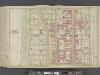
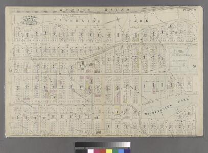
Manhattan, Double Page Plate No. 37 [Map bounded by W. 108th St., Central Park W., W. 97th St., Hudson River]
From Atlas of the city of New York, Manhattan Island. From actual surveys and official plans
[Plate 37: Bounded by W. 108th Street, Central Park West, W. 97th Street, and [Hudson River, Riverside Park] Riverside Drive.]
from Atlas of the city of New York, borough of Manhattan. From actual surveys and official plans / by George W. and Walter S. Bromley.
[Plate 37: Bounded by W. 108th Street, Central Park West, W. 97th Street and (Hudson River) Riverside Drive.]
from Atlas of the city of New York, Manhattan Island. From actual surveys and official plans / by George W. and Walter S. Bromley.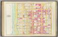
Pl. 37: ward 12.
1 : 1800 Bromley, George Washington; Bromley, Walter Scott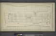
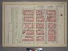
[Block No. 579 Map bounded by 95th Street, 5th Avenue, 94th Street, 6th Avenue]
from Maps & profiles of ground for new reservoir situated between 86th and 96th streets and between 5th and 7th avenues.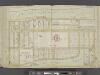
Manhattan, Double Page Plate No. 38 [Map bounded by Hudson River, W. 125th St., 9th Ave., W.1 08th St.]
From Atlas of the city of New York, Manhattan Island. From actual surveys and official plans
Plate 38: Bounded by (Hudson River) Riverside Park/Drive, W. 125th Street, 9th Avenue, W. 123rd Street, 10th Avenue, Morningside Avenue, Columbus [Avenue] and W. 108th Street.
from Atlas of the city of New York, Manhattan Island. From actual surveys and official plans / by George W. and Walter S. Bromley.
[Plate 38: Bounded by Hudson River (Riverside Park, Riverside Drive), W. 125th Street, Morningside Drive, Columbus Avenue, and W. 108th Street.]
from Atlas of the city of New York, borough of Manhattan. From actual surveys and official plans / by George W. and Walter S. Bromley.
Pl. 38: ward 12.
1 : 1800 Bromley, George Washington; Bromley, Walter Scott
Map of Morningside Park.
From Manhattan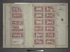
Plate 8: Part of Section 7.
from Atlas of the city of New York, borough of Manhattan / from actual surveys and official plans by George W. and Walter S. Bromley.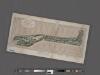
Preliminary Study for the Design of Morningside Park [1873].
From Manhattan
Part of Section 7: Plate 103.
from Atlas of the borough of Manhattan, city of New York.
Plate 102: Bounded by Cathedral Parkway, Amsterdam Avenue, W. 105th Street and (Riverside Park) Riverside Drive.
from Atlas of the borough of Manhattan, city of New York.
Plate 126: Bounded by W. 116th Street, Amsterdam Avenue, Cathedral Parkway and (Hudson River) Riverside Drive.
from Atlas of the borough of Manhattan, city of New York.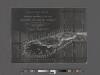
Revised general plan for Morningside Park, to accompany report by Frederick Law Olmsted and Calvert Vaux . . . September 28th, 1887.
From Manhattan
[Plate 100: Bounded by W. 105th Street, Amsterdam Avenue, W. 100th Street,and [Hudson River, Riverside Park] Riverside Drive.]
from Atlas of the borough of Manhattan, city of New York.
Plate 127: Bounded by W. 116th Street, Eighth Avenue, Cathedral Parkway and Amsterdam Avenue.
from Atlas of the borough of Manhattan, city of New York.
Plate 101: Bounded by W. 105th Street, Central Park West, W. 100th Street and Amsterdam Avenue.
from Atlas of the borough of Manhattan, city of New York.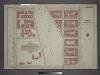
[Plate 5: Bounded by W. 116th Street, Eighth Avenue, Cathedral Parkway. and Amsterdam Avenue.]
from Atlas of the city of New York, borough of Manhattan / from actual surveys and official plans by George W. and Walter S. Bromley.
Plate 6: Part of Section 7.
from Atlas of the city of New York, borough of Manhattan / from actual surveys and official plans by George W. and Walter S. Bromley.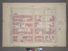
Plate 17, Part of Section 7: [Bounded by Cathedral Parkway, Central Park West, W. 105th Street and Amsterdam Avenue.]
from Atlas of the city of New York, borough of Manhattan. From actual surveys and official plans / by George W. and Walter S. Bromley.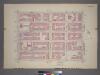
Plate 16, Part of Section 7: [Bounded by W. 105th Street, Amsterdam Avenue, W. 100th Street and (Hudson River - Riverside Park) Riverside Drive.]
from Atlas of the city of New York, borough of Manhattan. From actual surveys and official plans / by George W. and Walter S. Bromley.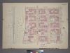
Plate 15, Part of Section 7: [Bounded by W. 105th Street, Amsterdam Avenue, W. 100th Street and (Hudson River - Riverside Park) Riverside Drive.]
from Atlas of the city of New York, borough of Manhattan. From actual surveys and official plans / by George W. and Walter S. Bromley.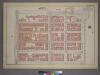
Plate 17, Part of Section 7: [Bounded by Cathedral Parkway, Central Park West, W. 105th Street, and Amsterdam Avenue.]
from Atlas of the city of New York, borough of Manhattan. From actual surveys and official plans / by George W. and Walter S. Bromley.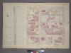
Plate 18, Part of Section 7: [Bounded by Cathedral Parkway, Amsterdam Avenue, W. 105th Street and (Hudson River - Riverside Park) Riverside Drive.]
from Atlas of the city of New York, borough of Manhattan. From actual surveys and official plans / by George W. and Walter S. Bromley.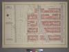
Plate 18, Part of Section 7: [Bounded by Cathedral Parkway, Amsterdam Avenue, W. 105th Street and (Riverside Park) Riverside Drive.]
from Atlas of the city of New York, borough of Manhattan. From actual surveys and official plans / by George W. and Walter S. Bromley.