Maps of Queens County

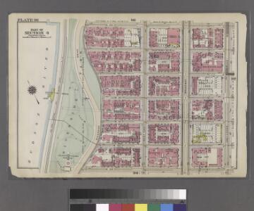
Part of Section 4 : Plate 96.
from Atlas of the borough of Manhattan, city of New York.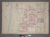
Plate 11, Part of Section 4: [Bounded by W. 95th Street, Amsterdam Avenue, W. 89th Street and (Hudson River - Riverside Park) Riverside Drive.]
from Atlas of the city of New York, borough of Manhattan. From actual surveys and official plans / by George W. and Walter S. Bromley.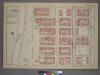
Plate 11, Part of Section 4: [Bounded by W. 95th Street, Amsterdam Avenue, W. 89th Street and (Riverside Park) Riverside Drive.]
from Atlas of the city of New York, borough of Manhattan. From actual surveys and official plans / by George W. and Walter S. Bromley.
Manhattan, V. 7, Plate No. 17 [Map bounded by W. 96th St., W. End Ave., W. 91st St., Riverside Ave.]
From Atlas 120. Vol. 7, 1902.
Manhattan, V. 7, Plate No. 13 [Map bounded by W. 91st St., W. End Ave., W. 86th St., Riverside Ave.]
From Atlas 120. Vol. 7, 1902.
Manhattan, V. 7, Plate No. 18 [Map bounded by W. 96th St., Amsterdam Ave., W. 91st St., W. End Ave.]
From Atlas 120. Vol. 7, 1902.
Manhattan V. 7, Plate No. 27 [Map bounded by West End Ave., W. 93rd St., Amsterdam Ave., W. 90th St.]
From Atlas 121. Vol. 7, pt. 1, 1912.
Manhattan, V. 7, Plate No. 14 [Map bounded by W. 91st St., Amsterdam Ave., W. 86th St., W. End Ave.]
From Atlas 120. Vol. 7, 1902.
Manhattan, V. 7, Plate No. 70 [Map bounded by Hudson River, Riverside Park]
From Atlas 120. Vol. 7, 1902.
Manhattan, V. 7, Plate No. 19 [Map bounded by W. 96th St., Columbus Ave., W. 91st St., Amsterdam Ave.]
From Atlas 120. Vol. 7, 1902.
Manhattan, V. 7, Plate No. 15 [Map bounded by W. 91st St., Columbus Ave., W. 86th St., Amsterdam Ave.]
From Atlas 120. Vol. 7, 1902.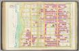
Pl. 36: ward 12.
1 : 1800 Bromley, George Washington; Bromley, Walter Scott
Plate 36: Bounded by W. 97th Street, Central Park West, W. 86th Street, and (Hudson River) Riverside Drive.
from Atlas of the city of New York, Manhattan Island. From actual surveys and official plans / by George W. and Walter S. Bromley.
[Plate 36: Bounded by W. 97th Street, Central Park West, W. 86th Street, and [Hudson River, Riverside Park] Riverside Drive.]
from Atlas of the city of New York, borough of Manhattan. From actual surveys and official plans / by George W. and Walter S. Bromley.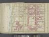
Manhattan, Double Page Plate No. 36 [Map bounded by W. 97th St., Central Park W., W. 86th St., Hudson St.,]
From Atlas of the city of New York, Manhattan Island. From actual surveys and official plans
Part of Sections 4 & 7 : Plate 98.
from Atlas of the borough of Manhattan, city of New York.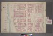
Plate 10, Part of Section 4: [Bounded by W. 89th Street, Amsterdam Avenue, W. 83rd Street and (Hudson River - Riverside Park) Riverside Drive.]
from Atlas of the city of New York, borough of Manhattan. From actual surveys and official plans / by George W. and Walter S. Bromley.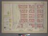
Plate 14, Part of Sections 4&7: [Bounded by W. 100th Street, Amsterdam Avenue, W. 95th Street and (Riverside Park) Riverside Drive.]
from Atlas of the city of New York, borough of Manhattan. From actual surveys and official plans / by George W. and Walter S. Bromley.
Part of Section 4 : Plate 94.
from Atlas of the borough of Manhattan, city of New York.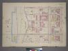
Plate 14, Part of Sections 4&7: [Bounded by W. 100th Street, Amsterdam Avenue, W. 95th Street and Riverside Drive.]
from Atlas of the city of New York, borough of Manhattan. From actual surveys and official plans / by George W. and Walter S. Bromley.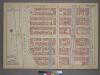
Plate 10, Part of Section 4: [Bounded by W. 89th Street, Amsterdam Avenue, W. 83rd Street and (Riverside Park) Riverside Drive.]
from Atlas of the city of New York, borough of Manhattan. From actual surveys and official plans / by George W. and Walter S. Bromley.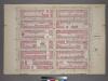
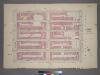
Plate 12, Part of Section 4: [Bounded by W. 95th Street, Central Park West, W. 89th Street and Amsterdam Avenue.]
from Atlas of the city of New York, borough of Manhattan. From actual surveys and official plans / by George W. and Walter S. Bromley.
[Plate 97: Bounded by W. 95th Street, Central Park West, W. 89th Street, and Amsterdam Avenue.]
from Atlas of the borough of Manhattan, city of New York.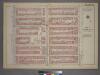
Plate 12, Part of Section 4: [Bounded by W. 95th Street, Central Park West, W. 89th Street and Amsterdam Avenue.]
from Atlas of the city of New York, borough of Manhattan. From actual surveys and official plans / by George W. and Walter S. Bromley.
[Plate 99: Bounded by W. 100th Street, Central Park West, W. 95th Street, and Amsterdam Avenue.]
from Atlas of the borough of Manhattan, city of New York.
Manhattan, V. 7, Plate No. 71 [Map bounded by Hudson River, Riverside Park]
From Atlas 120. Vol. 7, 1902.
Manhattan, V. 7, Plate No. 69 [Map bounded by Hudson River, Riverside Park]
From Atlas 120. Vol. 7, 1902.
Manhattan, V. 7, Plate No. 21 [Map bounded by W. 100th St., W. End Ave., W. 96th St., Riverside Ave.]
From Atlas 120. Vol. 7, 1902.
Manhattan, V. 7, Plate No. 22 [Map bounded by W. 100th St., Amsterdam Ave., W. 96th St., W. End Ave.]
From Atlas 120. Vol. 7, 1902.