Maps of Metropolitan France

Map of France, Spain, and Portugal; Switzerland in cantons [inset]; Island of Corsica [inset].
from Mitchell's new general atlas, containing maps of the various countries of the world, plans of cities, etc., embraced in fifty-three quarto maps., forming a series of eighty four maps and plans, together with valuable statistical tables.
France.
from A new systeme of the mathematicks: containing I. Arithmetick, as well natural and decimal, as in species, or the principles of algebra. II. Practical geometry, together with the first six books of Euclid's Elements, as also the eleventh and twelfth, symbo
Orbis Romani Pars Occidentalis.
1 : 10137600 Lucas, Fielding Jr.
Karte von Europa, 3
4 Blätter : 53 x 70 cm Verlag der Königlich-Preussischen Academie-Kunst- und Buchhandlung
Imperium Romanum
1 : 11100000 Evropa západní Bonne, Rigobert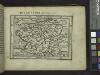
Gallia.
from Abraham Ortelius his epitome of the theater of the worlde / nowe latlye ... renewed and augmented ... by Micheal Coignet, mathematitian of Antwarpe.
Orbis Romani, occidentalis.
1 : 11500000 Anville, Jean Baptiste Bourguignon d, 1697-1782; M'Dermut, Robert
Imperii Romani, distracta
1 : 22200000 Evropa střední Bonne, Rigobert André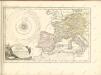

Carte de la Germanie et les diferents etats ou ses peuples ont porté leurs conquestes
Evropa jižní Chatelain, Henri-Abraham Chatelain
Orbis Romani pars occidentalis
1 : 10000000
Orbis Romani pars occidentalis
1 : 10600000 Evropa západní Anville, Jean-Baptiste Bourguinon d' Küffner, Paul in officina Weigelia-Schneideriana
Western Europe.
1 : 7303000 Fisher, Richard Swainson
Spain and Portugal.
from New & accurate description of the earth in all its empires, kingdoms and states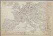
Centraal-, West-, en Zuid-Europa
1 : 3700000 [S.l. : s.n.]
Orbis Romani, pars occidentalis.
1 : 4300000 Anville, Jean Baptiste Bourguignon d, 1697-1782
[Ethnographische Karte von Europa]
Zweiter Band, enthaltend in vier Abtheilungen die Vertheilung der Organismen: 5. Pflanzen-Geographie, 6. Thier-Geographie, 7. Anthropographie, 8. Ethnographie Humboldt, Alexander von Verlag von Justus Perthes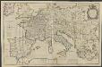
IMPERII | CAROLI MAGNI | et vicinarum regionum | DESCRIPTIO, | Dedicata et inscripta | LVDOVICO, | REGI, VICTORI, | ET DEFENSORI ECCLESIÆ | CHRISTI
ab Auctore Petro Bertio | ejusdem Cosmographo. [Amsterdam : Joan Blaeu]
Western Europe - communications.
1 : 5300000 John Bartholomew and Son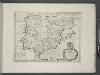
Spain and Portugal.
from A new sett of maps both of antient and present geography : wherein not only the latitude and longitude of many places are corrected according to the latest observations, but also the most remarkable differences of antient and present geography may be quickly discern'd by a bare inspection or comparing of correspondent maps, which seems to be the most natural and easy method to lead young students (for whose use the work is principally intended) unto a competent knowledge of the geographical science : together with a geographical treatise particularly adapted to the use and design of these maps / by Edward Wells, M.A. and student of Christ-Church, Oxon.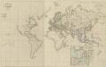
XI. Charte für die allgemeine Geschichte von der Selbstregierung Ludwig XIV. bis auf den österreichischen Erbfolgekrieg : d.i. von 1661 bis 1740 n. Christus
Entworfen von F.W. Benicken A. Falger gr. Weimar : im Verlage des L. Industrie-Comptoirs
Europa zur Zeit Napoleons
Europa Napoleon I., Frankreich, Kaiser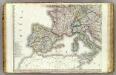
Europe 3.
1 : 3850000 Brue, Adrien Hubert, 1786-1832
Karten - Skizzen für die Schul - Praxis

Europe 1.
1 : 2800000 Anville, Jean Baptiste Bourguignon d, 1697-1782
Západní Evropa při konci XIV. věku

Western part of the mediterranean sea with the coasts of Spain France Italy Barbary
1 Blatt : 53 x 68 cm Sayer
La mer Mediterranée vers l'occident
1 Karte : Kupferdruck ; 38 x 49 cm Duval P. Duval
Western Europe.
1 : 6900000 Goodrich, S.G.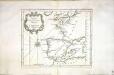
![Map of France, Spain, and Portugal; Switzerland in cantons [inset]; Island of Corsica [inset].](https://images-2.georeferencer.com/images/iiif/923616311946/full/,300/0/native.jpg)

