Maps of North Atlantic Ocean

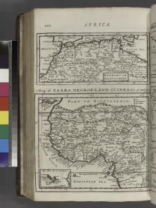
Barbary and Bildulgerid ; A map of Zaara, Negroe-land, Guinea, &c. (Inset: The Isles of C, Verd)
from A system of geography, or, A new & accurate description of the earth in all its empires, kingdoms and states : illustrated with history and topography, and maps of every country : fairly engraven on copper, according to the latest discoveries and corrections / by Herman Moll.
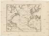
Karte des Atlantischen Oceans
1 Karte : Kupferdruck ; 48 x 60 cm Schrämbl zu finden in eigenem Verlage Schrämbl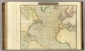
N. Atlantic Ocean.
1 : 22500000 Thomson, John
Carte de l'ocean Atlantique
1 Karte : Kupferdruck ; 47 x 61 cm Jefferys; Le Rouge chez Le Rouge rue des g.ds Augustins
Carte de l'océan Atlantique
1 Karte : Kupferdruck ; 48 x 61 cm Lattré chéz Lattré graveur du roy rue St. Jacques la porte cochère vis avis la rue de la Parcheminerie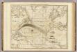
The Atlantic Ocean.
1 : 22500000 Pownall, Thomas
Mittel- und Nord-Africa und Arabien. Westliches Blatt
Stieler's Hand-Atlas Stieler, Adolf bei Justus Perthes
Tabula Moderna Prime Partis Aphricae [Karte], in: Claudii Ptolemei viri Alexandrini mathematice discipline philosophi doctissimi geographie opus [...], S. 263.
1 Karte aus Atlas Waldseemüller, Martin [und Ptolemaeus, Claudius] Übelin, Georg
Karte des Atlantischen Oceans
1 : 7500000 Atlantský oceán-oblast Schraembl, Franz Anton F.A. Schraembl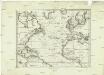
Karte des Atlantischen Oceans
1 : 22500000 Atlantský oceán-oblast Schraembl, Franz Anton F.A. Schraembl
Karte des Atlantischen Oceans
Atlantský oceán-oblast Schraembl, Franz Anton F.A. Schraembl
Noroeste de Africa
1 mapa. Datat al s. XIX. Gras y compañia, editores. Madrid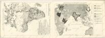
Meyers neuer Volksatlas
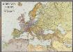
Karte von Europa
1 : 7500000 Berlin [etc.] : Ullstein
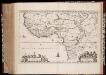
A draught of the coast of AFRICA from the streights mouth to cape bona Esprance
from The sea-atlas : containing an hydrographical description of most of the sea-coasts of the known parts of the world.
Geologie von Europa nach den Hauptverhältnissen
Erster Band, enthaltend in vier Abtheilungen die Erscheinungen der anorganischen Natur: 1. Meteorologie und Klimatographie. 2. Hydrologie und Hydrographie. 3. Geologie. 4. Tellurischer Magnetismus Humboldt, Alexander von Verlag von Justus Perthes
(World, gnomonic proj. I. Africa and south Europe)
1 : 5000000 Society for the Diffusion of Useful Knowledge (Great Britain)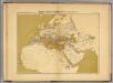
Monde connu des Grecs avant Alexandre.
1 : 22000000 Vivien de Saint-Martin, M.
Specialia vom Vulkan Gurtel des Atlantischen Oceans.
Berghaus, Heinrich
Pas-kaart van Europa
1 Karte : Kupferdruck ; 42 x 53 cm Doncker by Hendrick Doncker inde Nieubrugsteegh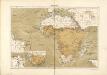
Atlas für Industrie- und Handelsgeographie: Für commercielle und technische Lehranstalten, für Kaufleute und Industrielle
Nigritarvm regio
1 : 10000000 Annotatie: Origineel is Blad 207 in atlas factice; Annotatie geografische gegevens: Met schaalstok: 10 Milliaria Germanica Communia (=9,2 cm) Amstelaedami : Ioannes Blaeu excud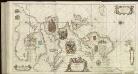
[122][125][Totius Europae littora ... pascaert ... Europa, uit: Atlas sive Descriptio terrarum orbis
Annotatie: Gedigitaliseerde versie. Amsterdam. Heiloo : Picturae (vervaardiger), 2015. tiff-bestand. Gedigitaliseerd: 07-01-2015; Origineel: Universiteitsbibliotheek Vrije Universiteit (XL.05127.-) ; Netherlands; Titelpagina ontbreekt Wit, Frederik de Amsterdam : Frederick de Wit
Europa recens descriptia. [Karte], in: Theatrum orbis terrarum, sive, Atlas novus, Bd. 1, S. 34.
1 Karte aus Atlas Blaeu, Joan Blaeu, Willem Janszoon
Africa, including the Mediterranean
1 : 1
Übersichts Karte zu den Reisen in Europa, Asien und Afrika
1 : 11700000 Afrika severovýchodní Verlag der E. Schweizerbrat'schen Buchhandlung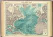
North Atlantic Ocean.
1 : 25000000 John Bartholomew & Co.
[Verbreitung und Vertheilung der Europäischen Vögel]
Zweiter Band, enthaltend in vier Abtheilungen die Vertheilung der Organismen: 5. Pflanzen-Geographie, 6. Thier-Geographie, 7. Anthropographie, 8. Ethnographie Humboldt, Alexander von Verlag von Justus Perthes