Maps of China

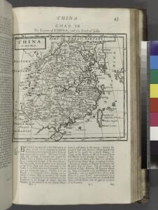
China.
from A system of geography, or, A new & accurate description of the earth in all its empires, kingdoms and states : illustrated with history and topography, and maps of every country : fairly engraven on copper, according to the latest discoveries and corrections / by Herman Moll.
Charte von China und den angränzenden Ländern, und Völkerschaften so wie dem letzten Kaiser Tschien-Long unterworfen waren
1 : 47500000 Asie jihovýchodní Macartney, George Macartney
Charte von China und den angränzenden Ländern, und Völkerschaften so wie dem letzten Kaiser Tschien-Long unterworfen waren
1 : 47500000 Asie jihovýchodní Macartney, George Macartney
CHARTE von CHINA und den angränzenden Ländern, und Völkerschaften so wie sie dem letzten Kaiser Tschien-Long unterworfen waren
1 : 47500000 Asie jihovýchodní Macartney, George Macartney
Undecima Asiae Tabula [Karte], in: Claudii Ptolemei viri Alexandrini mathematice discipline philosophi doctissimi geographie opus [...], S. 223.
1 Karte aus Atlas Waldseemüller, Martin [und Ptolemaeus, Claudius] Übelin, Georg
India, or the Mogul's Empire.
from New & accurate description of the earth in all its empires, kingdoms and states
East India.
from A new systeme of the mathematicks: containing I. Arithmetick, as well natural and decimal, as in species, or the principles of algebra. II. Practical geometry, together with the first six books of Euclid's Elements, as also the eleventh and twelfth, symbo
Atlas für Industrie- und Handelsgeographie: Für commercielle und technische Lehranstalten, für Kaufleute und Industrielle

Ostindien und China
E. von Sydow's Schul-Atlas in sechs und dreissig Karten Sydow, Emil von bei Justus Perthes
Map of Hindoostan, Farther India, China, and Tibet.
from Mitchell's new general atlas, containing maps of the various countries of the world, plans of cities, etc., embraced in fifty-three quarto maps., forming a series of eighty four maps and plans, together with valuable statistical tables.
Tableau l'historie de L'Asie, Inde, Chine, Japon.
1 : 33200000 Duval, Henri
Tabula Asiae VIII. [Karte], in: Geographia universalis vetus et nova complectens Claudii Ptolemaei Alexandrini enarrationis libros VIII, S. 287.
1 Karte aus Atlas Münster, Sebastian [und Ptolemaeus, Claudius]
Hindoostan, Farther India, China, Tibet.
1 : 17500000 Williams, W. (Wellington)
Map Of Hindoostan, Farther India, China, and Tibet.
1 : 17600000 Mitchell, Samuel Augustus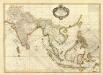
Composite: Indes.
1 : 10000000 Bonne, Rigobert, 1727-1794
Hindoostan, Farther India, China, Tibet.
1 : 17500000 Mitchell, Samuel Augustus
Hindoostan, Farther India, China, Tibet.
1 : 17500000 Mitchell, Samuel Augustus
Hindoostan, Farther India, China, Tibet.
1 : 17500000 Mitchell, Samuel Augustus Jr.
Hindoostan, Farther India, China, Tibet.
1 : 17500000 Williams, W. (Wellington)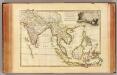
Indes Orientales.
1 : 16250000 Bonne, Rigobert, 1727-1794
Ostindien und China
1 : 25000000 Himálaj Kocen, Blaž Eduard Hölzel
India int. Gangem merid. India ext. Gangem, Sinarum situs
1 : 7600000 Ganga (Indie a Bangladéš) Reichard, Christian Gottlieb Campius, D. a D. Campio
Ostindien.
1 : 22000000 Reichard, C. G.
Ost-Indien mit den Inseln
Hand-Atlas über alle Theile der Erde nach dem neuesten Zustande und über das Weltgebäude Stieler, Adolf bei Justus Perthes
Ostindien
Neuester Schul-Atlas Walch, Johann im Verlag bei Joh. Walch
Indiae orientalis, nec non insularum adiacentium nova descriptio
1 : 15000000 Asie jihovýchodní Visscher, Nicolaes Jansz.
Indiae orientalis, nec non insularum adiacentium nova descriptio
1 : 15000000 Asie jihovýchodní Visscher, Nicolaus per Nicolaum Visscher
Ost-Indien
Handatlas über alle Theile der Erde und über das Weltgebäude Stieler, Adolf Justus Perthes
Ostindien
Allgemeiner Atlas [Walch, Johannes] im Verlag bei Johannes Walch