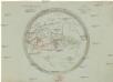
Maps of Algeria

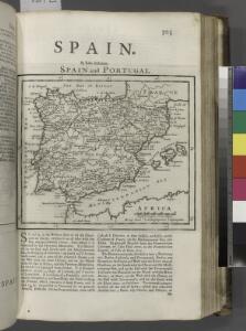
Spain and Portugal.
from New & accurate description of the earth in all its empires, kingdoms and states
Europa befolkningskarta

Imperii Romani.
1 : 9850000 Vivien de St Martin, L.
Orbis Romani pars occidentalis
1 : 10600000 Evropa západní Anville, Jean-Baptiste Bourguinon d' Küffner, Paul in officina Weigelia-Schneideriana
Partie occidentale de la mer Méditerranée
1 Karte : Kupferdruck ; 49 x 55 cm Robert de Vaugondy Didier Robert de Vaugondy
Bullettino decadico dell'osservatorio ed archivio centrale geodinamico
1 : 1200000 1886/18, Blatt 1 Archivio Centrale Geodinamico
Orbis Romani, occidentalis.
1 : 11500000 Anville, Jean Baptiste Bourguignon d, 1697-1782; M'Dermut, Robert
Patriarchati Occidentalis. (1826)
1 : 12100000 Tanner, Henry S.
La mer Mediterranée vers l'occident
1 Karte : Kupferdruck ; 38 x 49 cm Duval P. Duval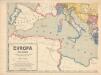
Evropa XIX. století: od vídeňského kongresu r. 1815, do rozhodnutí na frontách světové války r. 1918
Kašpar, Jan
Orbis Romani, pars occidentalis.
1 : 4300000 Anville, Jean Baptiste Bourguignon d, 1697-1782
Orbis Romani pars occidentalis
1 : 10000000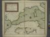
A new chart of the coast of the MEDITERRANEAN SEA
from The sea-atlas : containing an hydrographical description of most of the sea-coasts of the known parts of the world.
Imperii Romani, distracta
1 : 22200000 Evropa střední Bonne, Rigobert André
Imperium Romanum
1 : 11100000 Evropa západní Bonne, Rigobert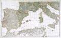
Prémière partie de la carte d'Europe contenant la France, l'Alemagne, l'Italie, l'Espagne & les isles britanniq.s, 2
1 Blatt : 53 x 85 cm s.n.
Das Mittelländische Meer
Stieler's Hand-Atlas Stieler, Adolf bei Justus Perthes
Karte von Europa, 3
4 Blätter : 53 x 70 cm Verlag der Königlich-Preussischen Academie-Kunst- und Buchhandlung
Western part of the mediterranean sea with the coasts of Spain France Italy Barbary
1 Blatt : 53 x 68 cm Sayer
[Historisch-geographischer Atlas zu den allgemeinen Geschichtswerken von C. v. Rotteck, Pölitz u. Becker] : Die Küsten des Mittelländischen Meeres zur Uebersicht der ältesten Kolonisationen
von Julius Loewenberg [Freiburg im Breisgau] : [Herder]
Orbis Romani Pars Occidentalis.
1 : 10137600 Lucas, Fielding Jr.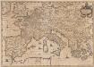
Imperium Caroli Magni [Karte], in: Novus atlas absolutissimus, Bd. 4, S. 28.
1 Karte aus Atlas Janssonius Offizin


Nordwestliches Africa
Neuer Handatlas über alle Theile der Erde Kiepert, Heinrich Verlag von Dietrich Reimer
Carte d'Europe ou sont tracées les limites des empires, royaumes, et etats souverains, feuille 5
1 Blatt : 56 x 87 cm Semen etc
Carte de la Germanie et les diferents etats ou ses peuples ont porté leurs conquestes
Evropa jižní Chatelain, Henri-Abraham Chatelain
[Ethnographische Karte von Europa]
Zweiter Band, enthaltend in vier Abtheilungen die Vertheilung der Organismen: 5. Pflanzen-Geographie, 6. Thier-Geographie, 7. Anthropographie, 8. Ethnographie Humboldt, Alexander von Verlag von Justus Perthes
Das Mittellandische Meer Und Nord-Afrika.
1 : 7500000 Petermann, A.