Maps of Metropolitan France

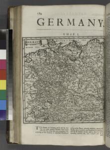
Germany.
from A system of geography, or, A new & accurate description of the earth in all its empires, kingdoms and states : illustrated with history and topography, and maps of every country : fairly engraven on copper, according to the latest discoveries and corrections / by Herman Moll.
Skizzen zu den größeren Manövern der fremden Armeen 1906
Francie Streffleur, Valentin Ritter von L. W. Seidel & Sohn
[Centralis Europae]
Evropa střední Schedel, Hartmann
Porostní mapa revíru Srbice
1 : 2880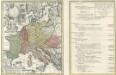
Tab. IV. Imperii Francici vel Romano German S. Romani Occid.
1 : 8500000 Mollova mapová sbírka Homann, Johann Baptist Homann, Johann Baptista - dědici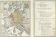
Tab. IV. Imperii Francici vel Romano-German. S. Romani Occid.
1 : 8500000 Mollova mapová sbírka Homann, Johann Baptist Homann, Johann Baptista - dědici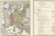
Tab. IV. Imperii Francici vel Romano-German. S. Romani Occid.
1 : 8500000 Mollova mapová sbírka Homann, Johann Baptist Homann, Johann Baptista - dědici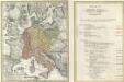
Tab. IV. Imperii Francici vel Romano-German. S. Romani Occid.
1 : 8500000 Mollova mapová sbírka Homann, Johann Baptist Homann, Johann Baptista - dědici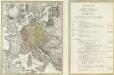
Tab. IV. Imperii Francici vel Romano-German. S. Romani Occid.
1 : 8500000 Mollova mapová sbírka Homann, Johann Baptist Homann, Johann Baptista - dědici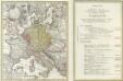
Tab. IV. Imperii Francici vel Romano-German. S. Romani Occid.
1 : 8500000 Mollova mapová sbírka Homann, Johann Baptist Homann, Johann Baptista - dědici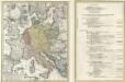
Tab. IV. Imperii Francici vel Romano-German. S. Romani Occid.
1 : 8500000 Mollova mapová sbírka Homann, Johann Baptist Homann, Johann Baptista - dědici
Deutschland, Niederlande, Belgien und Schweiz
Schul-Atlas über alle Theile der Erde nach dem neuesten Zustande, und über das Weltgebäude Stieler, Adolf Justus Perthes
France, Switzerland, Germany.
Goodrich, S.G.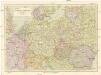
Střední Evropa
1 : 3000000 Evropa střední Kuchař, Karel Janka, Jaromír V. Neubert a synové
[Historisch-geographischer Atlas zu den allgemeinen Geschichtswerken von C. v. Rotteck, Pölitz u. Becker] : Gallien, Britannien, Germanien und die obern Donau-Länder nach Cæsar, Tacitus, Ptolemæus, Plinius, etc.
von Joh. Val. Kutscheit Lithographie der Herderschen Verlags-Handlung zu Freiburg im Breisg. [Freiburg im Breisgau] : [Herder]
Rozšíření nejstarší keramiky české v Evropě
Evropa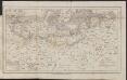
Map of the Post-Route to & from St. Petersburgh
1 : 24000000 Osteuropa Deutschland Polen Russland Reiseweg Postroute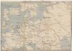
Schiffbare Wasserstrassen in Mitteleuropa
1 : 15000 Evropa střední Oelwein, A.
2. Pyrenäenfriede 1659
1 : 30000000 Mitteleuropa Pyrenäenfriede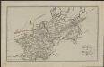
Schul-Atlas für die alte Erdbeschreibung : zur allgemeinen Schul-encyclopädie gehörig
J. H. Campe Zusammensetzung und Zeichnung von [...] Dufour, unter Leitung von Heusinger ; gestochen von Frentzel. Braunschweig : Schulbuchhandlung
Gran carta del teatro della guerra nel 1870
1 : 2340000 Evropa střední Stabilimento civelli
Itineraire-Karte
1 : 6000000 Evropa
Germany.
from Carey's general atlas, improved and enlarged : being a collection of maps of the world and quarters, their principal empires, kingdoms, &c.
Eisenbahn-Übersichtskarte von Mittel-Europa
Evropa R. v. Waldheim
Eisenbahn-Übersichtskarte von Mittel-Europa
Evropa R. v. Waldheim
Eisenbahn-Übersichtskarte von Mittel-Europa
Evropa
Eisenbahn-Übersichtskarte von Mittel-Europa
Evropa R. v. Waldheim
Germany.
from A new systeme of the mathematicks: containing I. Arithmetick, as well natural and decimal, as in species, or the principles of algebra. II. Practical geometry, together with the first six books of Euclid's Elements, as also the eleventh and twelfth, symbo