Maps of Grand Est

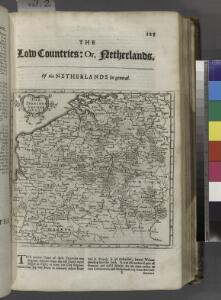
The Spanish Netherlands.
from A system of geography, or, A new & accurate description of the earth in all its empires, kingdoms and states : illustrated with history and topography, and maps of every country : fairly engraven on copper, according to the latest discoveries and corrections / by Herman Moll.
Le Cours du Rhein
1 : 1100000 Mollova mapová sbírka Fer, Nicolas de Fer, Nicolas de
Carte des peuples riverains du Rhin au temps d’Auguste et de ses successeurs immédiats
Mitteleuropa Rhein-Gebiet ethnische Gruppe Germanen
Unsere Westgrenze
1 : 1000000 Evropa západní Velhagen & Klasing
Germaniae Cisrhenanae ut inter J. Caesaris et Trajani fuit imperia Scaldis item Mosae ac Rheni Ostiorum Antiqua descriptio.
1 : 2500000 [S.l.] : [s.n.]
Descriptio Germaniae Inferioris. [Karte], in: Theatrum orbis terrarum, S. 162.
1 Karte aus Atlas Ortelius, Abraham Vrients, Jan Baptista
[Recto], uit: Descriptio Germaniae Inferioris
1 : 1000000 Annotatie: Waarschijnlijk gegraveerd door F. Hogenberg; Uit: Theatrum Orbis Terrarm. - Antwerpen, 1570 Hogenberg, Franz [Antwerpen : Abraham Ortelius]
Europe Centrale (Partie Occidentale).
1 : 1750000 Jouvet et Cie.
Descriptio Germaniae Inferioris. [Karte], in: Theatrum orbis terrarum, S. 42.
1 Karte aus Atlas Ortelius, Abraham
Map Western Front.
1 : 633600 C.S. Hammond & Company
D.O.M. Carte Generale Des Dixsept Provinces des Pays-Bas avec les Frontieres de France, d'Allemagne et Partie de l'Angleterre Nouvellement dreßée sur plusieur Momoires tirés sur les Lieux pendant les Guerres
1 : 750000 Mollova mapová sbírka Sengre, Henri Misson, François Maximilien
Leo Belgicus / Johan van Doetechum fecit
1 : 350000 Annotatie: Facs. van de uitg.: [Amsterdam] : C.J. Visscher excudit, 1650. - Het betreft de 3e staat van de kaart van J. van Doetechum uit 1598, bijgewerkt door C.J. Visscher; Uitg. t.g.v. de tentoonstelling "De wereld op papier", in het Amsterdams Historisch Museum, april 1967 Joannes van Doetecum de Oudere -1605; Visscher, Claes Jansz. [S.l. : s.n.]
Kriegsschauplatz oder Graenzkarte zwischen Deutschland und Franckreich
1 Karte auf 2 Blättern : Kupferdruck ; 61 x 56 cm Walch zu haben bei Ioh. Walch im eignem Kunstverlag
Le royaume de France, 2
1 Blatt : 60 x 43 cm Jaillot
[Kaart], uit: Kaart der bevaarbare waterloopen van België, Nederland, N.-Frankrijk, W.-Duitschland, en den Rijn van Rotterdam tot Basel = Carte des voies navigables de la Belgique, la Hollande, N. de la France, Allemagne Est, et le Rhin de Rotterdam à Bâle = Wasserstrassen Karte von Belgien, Holland, N. Frankreich, W. Deutschland und der Rhein von Rotterdam bis Basel
1 : 800000 Antwerpen : Seghers
[Königreich der Niederlande]
Neuester Schul-Atlas Walch, Johann im Verlag bei Joh. Walch
Inferioris Germaniae provinciarum nova descriptio / [Willem Jansz. Blaeu]
1 : 900000 Annotatie: Onder de titel een nadere omschrijving in het Latijn en Nederlands; Aan het oorspronkelijke kaartbeeld zijn het Bourtangerveen en Fort Bourtange toegevoegd; Lit.: Monumenta cartografica Neerlandica, IV, p. 31-32, 146-153, facs. 5; Oorspr. uitg.: 1604 Blaeu, Willem Jansz. Amstelodami : ex officina Guilielmi Johannis
Bojište [sic] 1870
Belgie Bedřich Sandtner
Holland or the Seven United Provinces, and the Netherlands.
from Carey's general atlas, improved and enlarged : being a collection of maps of the world and quarters, their principal empires, kingdoms, &c.
Nova mappa geographica Belgii universi seu Inferioris Germaniae quam XVII Provinciae, Austriaco, Gallico et Batavo sceptro parentes constituunt
1 : 1000000 cura et sum[p]tibus Joh: Michaelem Probst Aug. Vind. Aug. Vind : J.M. Probst
Belgivm sive Inferior Germania
1 : 1500000 Mollova mapová sbírka Weigel, Christoph Goos, Abraham Weigel, Christoph I.
67-68. North-East France, Belgium, Luxemburg. The World Atlas.
1 : 1250000 USSR (Union of Soviet Socialist Republics).
XVII. Provinciae Belgii sive Germaniae Inferioris
1 : 1100000 Mollova mapová sbírka Seutter, Matthäus Seutter, Matthäus
Tabula generalis totius Belgii qua provinciae XVII Infer. Germaniae olim sub S. R. I. circulo Burgundiae comprehensae nunc in Varias Potentias tum liberas utpote Prov. VII Foederatas, tum reliquas Hispaniae, et Galliae coronis subjectas, separata ostenduntur
1 : 1000000 Mollova mapová sbírka Homann, Johann Baptist Homann, Johann Baptista
Zur Geschichte von Italien
Belgie R. Gaertner
Atlas für Handel und Industrie: Für Kaufleute, Fabrikante u. Gewerbetreibende, Handlungs- u. Gewerbe-Schulen

XVII Provinciae Belgii sive Germaniae Inferioris priscis temporibus circulo Burgundisco S.R.I. annumeratae quarum X hodie maximam partem Hispaniarum, non nullae Galliae regis ditioni subjacent, VII vero sub nomine Foederatarum Provinciarum Libertate gaudent
1 : 1250000 studio et opera Tobiae Conradi Lotter G. Rogg del. Augusta [Vindelicorum], : Tobiae Conradi Lotter
Septendecim provinciae Germaniae Inferior. uti sunt sub potestate regum Franciae et Hispaniae Ordinumque Generalium provinciarum unitarum : una cum episcopatibus Monasteriensi, Coloniensi, Leodiensi, et Cameracensi ...
1 : 1000000 P. Schenk exc. Amst. : P. Schenk exc.