Maps of British Isles

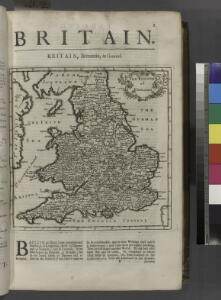
Britain.
from New & accurate description of the earth in all its empires, kingdoms and states
Kompas van Groot-Brittannië en Ierland
1 : 2000000 Annotatie: Met lijst van graafschappen; Annotatie geografische gegevens: Met schaalstok; Legenda; Inzetkrt.: [Orkaden en Shetland Eil.] Kompas, Den Haag Den Haag : Kompas
England und die Nordseeländer
1 : 3500000 Severní moře (oblast) Kartogr. Anst. Freytag & Berndt
Anglia II. Nova Tabula [Karte], in: Claud. Ptolemaeus. Geographia lat. cum mappis [...], S. 335.
1 Karte aus Atlas Münster, Sebastian [und Ptolemaeus, Claudius]
England, Schottland und Irland
Schul-Atlas in 36 Karten Völter, Daniel Verlag der J.M. Dannheimer'schen Buchhandlung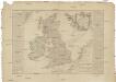
Carte des isles Britanniques
1 : 2600000 Irsko Nolin, Jean-Baptiste Daumont chez Daumont
England.
from A new systeme of the mathematicks: containing I. Arithmetick, as well natural and decimal, as in species, or the principles of algebra. II. Practical geometry, together with the first six books of Euclid's Elements, as also the eleventh and twelfth, symbo
Tidal Chart of the British Seas
The physical atlas Johnston, Alexander Keith William Blackwood & Sons
Carte pour l'introduction à l'histoire d'Angleterre
1 Karte : Kupferdruck ; 21 x 25 cm, Bildgrösse 52 x 60 cm Châtelain s.n.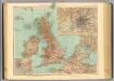
45-46. Gran Bretagna.
1 : 3000000 Touring club italiano
Les isles Britanniques comprenant les royaumes d'Angleterre, Ecosse et Irlande
1 Karte : Kupferdruck ; 51 x 67 cm Crépy; Crépy chez Crepy rue S. Jacques à l'Image Saint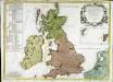
Les isles Britannicques ou sont le royaume d'Angleterre diuisé en ses quatre roy.mes des Saxons
1 Karte : Kupferdruck ; 52 x 71 cm Speed; Gordon; Pont s.n.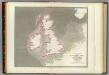
Tidal chart British Seas.
1 : 4900000 Russell, J. Scott (John Scott), 1808-1882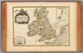
Isles Britanniques.
1 : 3800000 Janvier, Jean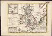
A general map of Great Britain and Ireland, with part of Germany, Holland, Flanders, France &c. agreeable to modern history
1 : 6500000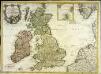
Carte des isles Britanniques contenant les royaumes d'Angleterre, d'Ecosse, d'Irlande et isles dépendantes
1 Karte : Kupferdruck ; 53 x 72 cm Flink; Mondhare chés Mondhare rue St. Jacques
Regnorvm Magnae Britanniæ et Hiberniae mappa geographica
1 Karte : Kupferdruck ; 46 x 53 cm Mayer Homännische Erben
Magna Britannia complectens Angliæ, Scotiæ et Hiberniæ regna
1 Karte : Kupferdruck ; 47 x 56 cm Homann Johann Baptist Homann
Magna Britannia complectens Angliæ, Scotiæ et Hiberniæ regna
1 Karte : Kupferdruck ; 47 x 56 cm Homann Johann Baptist Homann
X. Charte für die allgemeine Geschichte vom Anfange des XXX-jährigen Krieges bis zur Selbstregierung Ludwig XIV : d.i. von 1618 bis 1661 n. Christus
Entworfen von F.W. Benicken A. Falger gr. Weimar : im Verlage des L. Industrie-Comptoirs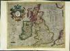
Anglia, Scotia et Hibernia
1 Karte : Kupferdruck ; 31 x 39 cm Mercator; Hondius Henricus Hondius
Anglia Scotia et Hibernia
1 Karte : Kupferdruck ; 17 x 24 cm Mercator Cloppenburgh
Anglia, Scotia et Hibernia
1 Karte : Kupferdruck ; 31 x 39 cm Mercator; Hondius Jodocus Hondius
Carte des grandes routes d'Angleterre, d'Ecosse, et d'Irlande
1 Karte : Kupferdruck ; 46 x 57 cm Robert de Vaugondy; Haussard s.n.
Magnæ Britanniæ tabula
1 Karte : Kupferdruck ; 46 x 55 cm Visscher; Schenk nunc apud P. Schenk jun
Novissima et accuratissima totius Angliæ, Scotiæ et Hiberniæ tabula
1 Karte : Kupferdruck ; 49 x 56 cm Danckerts Danckerts
Magnæ Britanniæ et Hiberniæ nova descriptio
1 Karte : Kupferdruck ; 41 x 52 cm Janssonius apud Ioannem Ianssonium
Accuratissima Angliæ Scotiæ et Hiberniæ tab
1 Karte : Kupferdruck ; 49 x 58 cm Allard by Carolus Allard op den Dam
Magnæ Britanniæ tabula, Angliam, Scotiam, et Hiberniam continens
1 Karte : Kupferdruck ; 44 x 55 cm Ram in lucem edita per Ioannem de Ram
Novissima et accuratissima totius Angliæ Scotiæ et Hiberniæ tabula
1 Karte : Kupferdruck ; 48 x 55 cm Danckerts; Homann; Funck David Funck excudit
Nova totius Angliæ, Scotiæ, et Hiberniæ tab
1 Karte : Kupferdruck ; 46 x 54 cm Schagen by Gerrit v. Schagen voor aen op de Haerlemmerdyck inde Stuerman
Nova totius Angliæ, Scotiæ, et Hiberniæ tab
1 Karte : Kupferdruck ; 47 x 55 cm Wit by Frederick de Wit in de Kalverstraet by den dam inde Witte Pascaert
Nieuwe perfecte carte van Engelant Schotlant en Ierlant
1 Karte : Kupferdruck ; 41 x 52 cm Wit by Frederick de Wit
Magnæ Britanniæ et Hiberniæ tabvla
1 Karte : Kupferdruck ; 36 x 48 cm Blaeu Guıljelmus Blaeuw excudit