Maps of Ireland

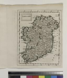
Ireland.
from A new systeme of the mathematicks: containing I. Arithmetick, as well natural and decimal, as in species, or the principles of algebra. II. Practical geometry, together with the first six books of Euclid's Elements, as also the eleventh and twelfth, symbo
A map of Ireland according to the best authorities.
from Carey's general atlas, improved and enlarged : being a collection of maps of the world and quarters, their principal empires, kingdoms, &c.
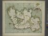
A new and correct chart of the coast of IRELAND
from The sea-atlas : containing an hydrographical description of most of the sea-coasts of the known parts of the world.
Li regni d'Inghilterra e d'Irlanda
1 Karte : Kupferdruck ; 29 x 38 cm Zatta Antonio Zatta
The Kingdom of Ireland devided into fewer provinces...
From Ireland
Ireland
Hand-Atlas über alle Theile der Erde nach dem neuesten Zustande und über das Weltgebäude Stieler, Adolf bei Justus Perthes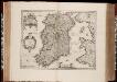
Hibernia Regnum vulgo Ireland / [Joannes Janssonius]
1 : 1300000 Annotatie: Oorspr. verschenen in: Gerardi Mercatoris et I. Hondii appendix atlas ... - Amsterdam : bey Johan Jansson, 1636; Origineel is Blad 32 in atlas factice Janssonius, Joannes (jr.) (1588-1664) Amstelodami : apud Ioannem Ianssonium
Hibernia Regnum Vulgo Ireland. [Karte], in: Novus atlas absolutissimus, Bd. 8, S. 183.
1 Karte aus Atlas Janssonius Offizin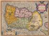
Hiberniae, Britannicae Insulae, Nova Descriptio. Irlandt. [Karte], in: Theatrum orbis terrarum, S. 42.
1 Karte aus Atlas Ortelius, Abraham
Ireland
Hand-Atlas über alle Theile der Erde nach dem neuesten Zustande und über das Weltgebäude Stieler, Adolf bei Justus Perthes
Hibernia Regnum Vulgo Ireland. [Karte], in: Theatrum orbis terrarum, sive, Atlas novus, Bd. 4, S. 547.
1 Karte aus Atlas Blaeu, Joan Blaeu, Willem Janszoon
Hibernia Regnum Vulgo Ireland. [Karte], in: Novus Atlas, das ist, Weltbeschreibung, Bd. 3, S. 383.
1 Karte aus Atlas Blaeu, Joan Blaeu, Willem Janszoon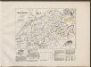
Hibernia Regnum Vulgo Ireland. [Karte], in: Le théâtre du monde, ou, Nouvel atlas contenant les chartes et descriptions de tous les païs de la terre, Bd. 3, S. 319.
1 Karte aus Atlas Blaeu, Willem Janszoon und Blaeu, Joan Blaeu, Willem Janszoon
Jreland
Stieler's Hand-Atlas Stieler, Adolf bei Justus Perthes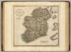
Ireland.
1 : 1150000 Cary, John, ca. 1754-1835
A new map of Ireland, divided into its provinces, counties and baronies, wherein are distinguished the bishopricks, borroughs, barracks, bogs, passes, bridges &c. with the principal roads, and the common reputed miles.
from The world described, or, A new and correct sett of maps : shewing the kingdoms and states in all the known parts of the earth, with the principal cities, and most considerable towns in the world ... / ... by Herman Moll, geographer ...


Ireland.
1 : 1500000 Petermann, A.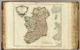
Royaume d'Irlande.
1 : 1080000 Robert de Vaugondy, Gilles, 1688-1766
Ireland
Handatlas über alle Theile der Erde und über das Weltgebäude Stieler, Adolf Justus Perthes
Ireland
Adolf Stieler's Handatlas über alle Theile der Erde und über das Weltgebäude Stieler, Adolf Justus Perthes

Composite: Ireland.
1 : 700000 Lizars, Daniel
Map of Ireland.
1 : 2300000 Bowen, Emanuel
Ireland
Hand-Atlas über alle Theile der Erde und über das Weltgebäude Stieler, Adolf Justus Perthes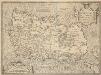
Hiberniae, Britannicae Insulae, Nova Descriptio. Irlandt. [Karte], in: Theatrum orbis terrarum, S. 89.
1 Karte aus Atlas Ortelius, Abraham Vrients, Jan Baptista
Ireland.
1 : 2750000 Seaman, James V.