Maps of British Isles

England.
from A new systeme of the mathematicks: containing I. Arithmetick, as well natural and decimal, as in species, or the principles of algebra. II. Practical geometry, together with the first six books of Euclid's Elements, as also the eleventh and twelfth, symbo
Kompas van Groot-Brittannië en Ierland
1 : 2000000 Annotatie: Met lijst van graafschappen; Annotatie geografische gegevens: Met schaalstok; Legenda; Inzetkrt.: [Orkaden en Shetland Eil.] Kompas, Den Haag Den Haag : Kompas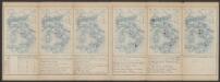
Anglia II. Nova Tabula [Karte], in: Claud. Ptolemaeus. Geographia lat. cum mappis [...], S. 335.
1 Karte aus Atlas Münster, Sebastian [und Ptolemaeus, Claudius]
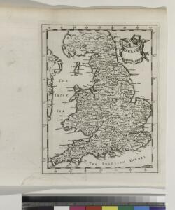
Britain.
from New & accurate description of the earth in all its empires, kingdoms and states
INSVLÆ | ALBION | et | HIBERNIA | cum minoribus adjacentibus
[Amsterdam : Joan Blaeu]
Carte vom Canal zwischen dem Atlantischen Meere und der Nord=See
1 Karte : Kupferdruck ; 47 x 49 cm Saltzenberg s.n.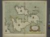
A new and correct chart of the sea coast of ENGLAND, SCOTLAND and IRELAND
from The sea-atlas : containing an hydrographical description of most of the sea-coasts of the known parts of the world.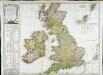
Carte des isles Britanniques qui renferment les royaumes d'Angleterre d'Ecosse [et] d'Irlande
1 Karte : Kupferdruck ; 53 x 59 cm Robert de Vaugondy; Beaublé; Fortin; Kitchin chés Fortin ingénieur du roi pour les globes et sphéres rue de la Harpe près celle du Foin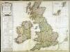
Carte des isles Britanniques qui renferment les royaumes d'Angleterre d'Ecosse [et] d'Irlande
1 Karte : Kupferdruck ; 53 x 59 cm Robert de Vaugondy; Beaublé; Delamarche; Kitchin chez le Sr. Delamarche géographe rue du Foin St. Jacques au collège de m.tre Gervais
Bradshaw's new railway map of Gt. Britain and Ireland shewing the stations-distance &c.
1 : 1560000 Bradshaw & Blacklock
Feuille 23 (B IV), uit: Carte géologique internationale de l'Europe : la carte, votée au congrès géologique international de Bologne en 1881, est exécutée conformément aux décisions d'une commission internationale, avec le concours des gouvernements, sous le dir. de M.M. Beyrich et Hauchecorne
Annotatie: Blad 48 gamme des couleurs; blad 49: bladwijzer en titelblad Heinrich Ernst Beyrich 1815-1896; Wi. Hauchecorne Berlin : Reimer / (Berlin: Institut lithographique)
Carte de l' Angleterre
1 : 5900000 Velká Británie Delamarche, Francois Alexander
Grossbritannien
Plastischer Schul-Atlas über alle Theile der Erde : in 24 Karten Woldermann, G Verlag von P. Eckerlein
Geology Of The British Isles.
1 : 1025000 Wyld, James, 1812-1887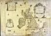
Les isles britaniques ou sont les royaumes d'Angleterre et d'Escosse que nous appellons la Grande Bretagne et celui d'Irlande
1 Karte auf 4 Blättern : Kupferdruck ; 72 x 86 cm Duval; Duval chez Mad.lle Du-Val fille de l'auteur sur le quay de l'Horloge du Palays pres la rue de Harlay a la couronne d'or
Carte des isles britaniques, où sont les royaumes d'Angleterre, et d'Escosse, que nous appellons Grande Bretagne
1 Karte : Kupferdruck ; 46 x 33 cm Duval chez l'auteur en l'isle du Palais sur le quay de l'Horloge
Carte des isles britaniques, où sont les royaumes d'Angleterre, et d'Escosse, que nous appellons Grande Bretagne
1 Karte : Kupferdruck ; 46 x 33 cm Duval chez l'auteur en l'isle du Palais sur le quay de l'Horloge
Novissima nec non perfectissima Regnorum Angliae, Scotiae et Hiberniae tabula, divisa in omnes suas partes et provincias
1 : 865000 Amstelodami : apud J. Covens et C. Mortier
Neueste Karte von Grossbritannien und Jreland
Grosser Hand-Atlas über alle Theile der Erde in 170 Karten Meyer, J. Verlag des Bibliographischen Instituts
Carte des grandes routes d'Angleterre, d'Ecosse, et d'Irlande
1 Karte : Kupferdruck ; 46 x 57 cm Robert de Vaugondy; Haussard s.n.
Magnæ Britanniæ tabula
1 Karte : Kupferdruck ; 46 x 55 cm Visscher; Schenk nunc apud P. Schenk jun
Novissima et accuratissima totius Angliæ, Scotiæ et Hiberniæ tabula
1 Karte : Kupferdruck ; 49 x 56 cm Danckerts Danckerts
Magnæ Britanniæ et Hiberniæ nova descriptio
1 Karte : Kupferdruck ; 41 x 52 cm Janssonius apud Ioannem Ianssonium
Accuratissima Angliæ Scotiæ et Hiberniæ tab
1 Karte : Kupferdruck ; 49 x 58 cm Allard by Carolus Allard op den Dam
Magnæ Britanniæ tabula, Angliam, Scotiam, et Hiberniam continens
1 Karte : Kupferdruck ; 44 x 55 cm Ram in lucem edita per Ioannem de Ram
Novissima et accuratissima totius Angliæ Scotiæ et Hiberniæ tabula
1 Karte : Kupferdruck ; 48 x 55 cm Danckerts; Homann; Funck David Funck excudit
Nova totius Angliæ, Scotiæ, et Hiberniæ tab
1 Karte : Kupferdruck ; 46 x 54 cm Schagen by Gerrit v. Schagen voor aen op de Haerlemmerdyck inde Stuerman
Nova totius Angliæ, Scotiæ, et Hiberniæ tab
1 Karte : Kupferdruck ; 47 x 55 cm Wit by Frederick de Wit in de Kalverstraet by den dam inde Witte Pascaert
Nieuwe perfecte carte van Engelant Schotlant en Ierlant
1 Karte : Kupferdruck ; 41 x 52 cm Wit by Frederick de Wit
Magnæ Britanniæ et Hiberniæ tabvla
1 Karte : Kupferdruck ; 36 x 48 cm Blaeu Guıljelmus Blaeuw excudit