Maps of England

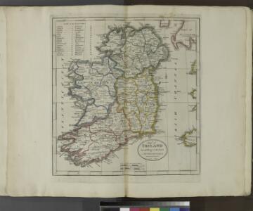
A map of Ireland according to the best authorities.
from Carey's general atlas, improved and enlarged : being a collection of maps of the world and quarters, their principal empires, kingdoms, &c.
Iles Britaniques routes.
1 : 2075000 Robert de Vaugondy, Gilles, 1688-1766

Ireland.
from A new systeme of the mathematicks: containing I. Arithmetick, as well natural and decimal, as in species, or the principles of algebra. II. Practical geometry, together with the first six books of Euclid's Elements, as also the eleventh and twelfth, symbo
Die Britischen Inseln 1066 bis 1485.
1 : 3100000 Spruner von Merz, Karl
Sheet 5 Belfast, uit: Ireland
1 : 126720 Annotatie: Enkele bladen dubbel. - Enkele bladen van een oudere uitg; De bladen 5 (1912) en 9 (1918) opgeborgen bij gevouwen kaarten. - Beide bladen met aantekeningen in rode en zwarte inkt; Annotatie geografische gegevens: Reduced from the one inch map; Met diagram van aangrenzende bladen, indexdiagram van de corresponderende bladen van de 'one inch map' en diagram van 'The National Grid' Dublin : Ordnance Survey of Ireland
Die Britischen Inseln seit 1485.
1 : 3000000 Spruner von Merz, Karl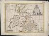
A new map of the Brittish Isles shewing their present genl. divisions, cities, and such other towns, or places, as answer to the towns of note in the time of the Romans
1 : 2851200
Die Britischen Inseln bis auf Wilhelm den Eroberer 1066.
1 : 3100000 Spruner von Merz, Karl
Philips Railway map of the British Isles

Hydrographical map, British Isles.
1 : 1600000 Stanford, Edward
British Islands.
1 : 3400000 Greenleaf, Jeremiah
British Islands.
1 : 3484800 Greenleaf, Jeremiah
Charte der vereinigten Königreiche Grossbritanien und Irland
1 : 2900000 Irsko Kipferling, Karl Joseph Kunst ind Industrie Comptoir
[Ethnographic Map of Great Britain and Ireland]
The physical atlas Johnston, Alexander Keith William Blackwood & Sons
British Isles. Pergamon World Atlas.
Polish Army Topography Service
British Isles.
1 : 2728000 Gray, Ormando Willis
Welká Británie a Iry
1 : 3360000 Irsko Merklas, Václav
Composite: British Isles.
1 : 633600 John Bartholomew & Co.
Novissima prae caeteris aliis accuratissima regnorum Angliae, Scotiae Hiberniaeq[ue] tabula
1 : 1850000 Irsko Wit, Frederick de F de Wit
Grossbritannien und Irland

Brittannicae Insule ex Aevi Romani Monumentis. (1826)
1 : 3900000 Tanner, Henry S.
[Historisch-geographischer Atlas zu den allgemeinen Geschichtswerken von C. v. Rotteck, Pölitz u. Becker] : Gross Britannien zur Uebersicht der Hauptbegebenheiten
von Julius Loewenberg Lithographie von B. Herder in Freiburg im Breisgau [Freiburg im Breisgau] : [Herder]
Iles Britanniques.
Andriveau-Goujon, J.
Iles Britanniques ou Royaume Uni de la Grand Bretagne et la l'Irland.
1 : 3300000 Monin, C.V.
TABULA NOVISSIMA ACCURATISSIMA REGNORUM ANGLIAE, SCOTIAE HIBERNIAE
1 : 1900000 Anglie Seutter, Matthäus Mattheo Seutter
Tabula novissima accuratissima regnorum Angliae, Scotiae Hiberniae
1 : 1900000 Irsko Seutter, Matthäus M. Seutter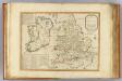
Invasions England, Ireland.
1 : 1770000 Robert Laurie & James Whittle
United Kingdom.
1 : 4100000 Darton, William