Maps of Hudson County

Plate 22:Map bounded by Grand Street, Attorney Street, Division Street, Allen Street.
from Maps of the city of New York / surveyed under directions of insurance companies of said city.
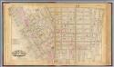
Manhattan, V. 1, Plate No. 52 [Map bounded by Grand St., Clinton St., Canal St., Essex St.]
From Atlas 108. Vol. 1, [1903?].
Plate 16, Part of Sections 1&2: [Bounded by Broome Street, Willett Street, Grand Street, East Broadway, Pike Street, Division Street and Orchard Street.]
from Atlas of the city of New York, borough of Manhattan. From actual surveys and official plans / by George W. and Walter S. Bromley.
Part of Sections 1 & 2 : Plate 16.
from Atlas of the borough of Manhattan, city of New York.
[Plate 26: Map bounded by Ludlow Street, Rivington Street, Ridge Street, Division Street; Including Rutgers St, Essex Street, Norfolk Street, Jefferson St, Suffolk Street, Clinton Street, Attorney Street, Montgomery St, Grand Street, Broome
from Maps of the city of New-York.
Plate 26: Map bounded by Rivington Street, Ridge Street, Division Street, Canal Street, Ludlow Street
from Maps of the city of New York.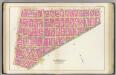
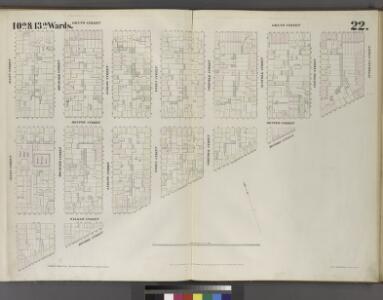
Pl. 5: wards 6, 10, 13-14.
1 : 1800 Bromley, George Washington; Bromley, Walter Scott
[Plate 25: Map bounded by Bowery, Rivington Street, Ludlow Street, Canal Street; Including Chrystie Street, Forsyth Street, Eldridge Street, Allen Street, Orchard Street, Hester Street, Grand Street, Broome Street, Delancy Street]
from Maps of the city of New-York.
Manhattan, V. 1, Double Page Plate No. 26 [Map bounded by Essex St., Rivington St., Ridge St., Division St.]
From Atlas 107. Vol. 1, 1894.
Manhattan, V. 1, Double Page Plate No. 24 1/2 [Map bounded by Grand St., Essex St., Rutgers St., E. Broadway, Pike St., Canal St., Bowery]
From Atlas 107. Vol. 1, 1894.
Part of Section 1 : Plate 13.
from Atlas of the borough of Manhattan, city of New York.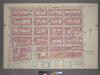
Plate 13, Part of Section 1: [Bounded by East Broadway, Montgomery Street, (East River) South Street, Pike Slip and Pike Street.]
from Atlas of the city of New York, borough of Manhattan. From actual surveys and official plans / by George W. and Walter S. Bromley.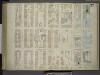
[Plate 27: Map bounded by Montgomery Street, South Street, Rutgers Slip, Rutgers Street, Division Street; Including East Broadway, Canal St, Henry Street, Madison Street, Monroe Street, Cherry Street, Water Street]
from Maps of the city of New-York.
Plate 15: Map bounded by Division Street, Jefferson Street, South Street, Pike Slip, Pike Street.
from Maps of the city of New York / surveyed under directions of insurance companies of said city.
Plate 27: Map bounded by Division Street, Montgomery Street, South Street, Rutgers Street
from Maps of the city of New York.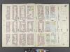
Manhattan, V. 1, Double Page Plate No. 27 [Map bounded by Montgomery St., East River, Rutgers Slip, Rutgers St., Division St.]
From Atlas 107. Vol. 1, 1894.
Plate 25: Map bounded by Rivington Street, Ludlow Street, Canal Street, Bowery
from Maps of the city of New York.
[Plate 21: Map bounded by Rivington Street, Attorney Street, Grand Street, Allen Street.]
from Maps of the city of New York / surveyed under directions of insurance companies of said city.
Plate 16: Map bounded by Division Street, Montgomery Street, South Street, Jefferson Street.
from Maps of the city of New York / surveyed under directions of insurance companies of said city.
[Plate 12: Map bounded by Rutgers Street, South Street, Market Street, Division Street; Including Pelham St, Pike Street, Pike Slip, Birmingham Street Mechanic's Street, East Broadway, Henry Street, Madison Street, Monroe Street, Cherry Stree
from Maps of the city of New-York.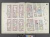
Manhattan, V. 1, Double Page Plate No. 12 [Map bounded by Rutgers St., East River, Market St., East Broadway]
From Atlas 107. Vol. 1, 1894.
[Plate 23: Map bounded by Bowery, Grand Street, Allen Street, Division Street.]
from Maps of the city of New York / surveyed under directions of insurance companies of said city.
Manhattan, V. 1, Plate No. 54 [Map bounded by Market St., E. Broadway, Rutgers St., Monroe St.]
From Atlas 108. Vol. 1, [1903?].
[Plate 12: Map bounded by Division Street, Rutgers Street, South Street, Market Street]
from Maps of the city of New York.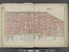
Manhattan, Double Page Plate No. 6 [Map bounded by Division St., Grand St., Corlears St., East River, Market St.]
From Atlas of the city of New York, Manhattan Island. From actual surveys and official plans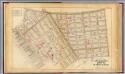
5. Ward 4, 7,10, 13.
1 : 2400 G.W. Bromley & Co.; Geo. W. Bromley & E. Robinson
Part of Section 1 : New York City.
from Atlas of the city of New York, Manhattan Island. From actual surveys and official plans / by George W. and Walter S. Bromley.
Part of Sections 1 & 2 : New York City.
from Atlas of the city of New York, borough of Manhattan. From actual surveys and official plans / by George W. and Walter S. Bromley.
Part of Sections 1 & 2 : New York City.
from Atlas of the city of New York, Manhattan Island. From actual surveys and official plans / by George W. and Walter S. Bromley.