Maps of Hudson County

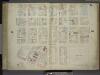
Plate 37: Map bounded by Spring Street, Varick Street, Vestry Street, West Street.
from Maps of the city of New York / surveyed under directions of insurance companies of said city.
[Plate 18: Map bounded by Spring Street, Clarke Street, Broome Street, Sullivan Street, Grand Street, Thompson Street, Laight Street, West Street]
from Maps of the city of New York.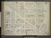
[Plate 18: Map bounded by Spring Street, Clarke Street, Sullivan Street, Grand Street, Thompson Street, Laight Street, West Street; Including Canal Street, Dominick Street, Broome Street, Watts Street, Desbrosses Street, Grand Street, Ve
from Maps of the city of New-York.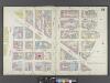
Manhattan, V. 1, Double Page Plate No. 18 [Map bounded by Spring St., Clarke St., Sullivan St., Laight St., West St.]
From Atlas 107. Vol. 1, 1894.
Part of Section 2 : Plate 21.
from Atlas of the borough of Manhattan, city of New York.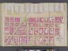
Manhattan, V. 4, Double Page Plate No. 16 [Map bounded by Hudson River, Morton St., Varick St., Vestry St.]
From Vol. 4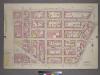
Plate 21, Part of Section 2: [Bounded by King Street, Macdougal Street, Watts Street and West Street.]
from Atlas of the city of New York, borough of Manhattan. From actual surveys and official plans / by George W. and Walter S. Bromley.
Part of Sections 1 & 2 : Plate 10.
from Atlas of the borough of Manhattan, city of New York.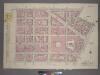
Plate 10, Part of Sections 1&2: [Bounded by Watts Street, Sullivan Street, Grand Street, West Broadway, N. Moore Street and West Street.]
from Atlas of the city of New York, borough of Manhattan. From actual surveys and official plans / by George W. and Walter S. Bromley.
Plate 35: Map bounded by Spring Street, Laurens Street, Canal Street, West Broadway, Beach Street, St. John's Lane, Laight Street, Canal Street, Varick Street.
from Maps of the city of New York / surveyed under directions of insurance companies of said city.
[Plate 19: Map bounded by West Houston Street, Varick Street, Spring Street, West Street; Including King Street, Charlton Street, Vandam Street, Washington Street, Greenwich Street, Hudson Street]
from Maps of the city of New-York.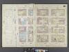
Manhattan, V. 1, Double Page Plate No. 19 [Map bounded by W. Houston St., Varick St., Spring St., West St.]
From Atlas 107. Vol. 1, 1894.
[Plate 19: Map bounded by Hamersley Street, Varick Street, Spring Street, West Street]
from Maps of the city of New York.
Plate 34: Map bounded by Vestry Street, Canal Street, Laight Street, St. John's Lane, West Broadway, Franklin Street, West Street.
from Maps of the city of New York / surveyed under directions of insurance companies of said city.
Plate 38: Map bounded by Hamersley Street, Varick Street, Spring Street, West Street.
from Maps of the city of New York / surveyed under directions of insurance companies of said city.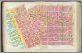
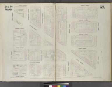
Pl. 4: wards 5-6, 8, 14.
1 : 1800 Bromley, George Washington; Bromley, Walter Scott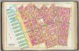
Pl. 9: wards 8-9 & 15.
1 : 1800 Bromley, George Washington; Bromley, Walter Scott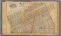
3. Wards 5, 8.
1 : 2400 G.W. Bromley & Co.; Geo. W. Bromley & E. Robinson
Plate 9: Bounded by Charles Street, Washington Street, W. 10th Street, Hudson Street, Christopher Street, Bedford Street, Barrow Street, Bleecker Street, Cornelia Street, Sixth Avenue, W. 3rd Street, W. Broadway, Broome Street, Hudson Street, Spring Stre
from Atlas of the city of New York, Manhattan Island. From actual surveys and official plans / by George W. and Walter S. Bromley.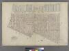
Part of Wards 5 & 8, New York City.
from Atlas of the city of New York : embracing all territory within its corporate limits from official records, private plans & actual surveys / by and under the supervision of E. Robinson & R.H. Pidgeon, civil engineers.
Part of Sections 1 & 2 : New York City.
from Atlas of the city of New York, Manhattan Island. From actual surveys and official plans / by George W. and Walter S. Bromley.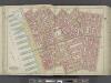
Manhattan, Double Page Plate No. 9 [Map bounded by Charles St., W. 3rd St., S. 5th Ave., Broome St., Hudson River]
From Atlas of the city of New York, Manhattan Island. From actual surveys and official plans
[Plate 9: Bounded by Charles Street, Washington Street, W. 10th Street, Hudson Street, Christopher Street, Bedford Street, Barrow Street, Bleecker Street, Cornelia Street, Sixth Avenue, W. 3rd Street, W. Broadway, Broome Street, Hudson Street, Spring Str
from Atlas of the city of New York, borough of Manhattan. From actual surveys and official plans / by George W. and Walter S. Bromley.
[Plate 4: Bounded by Spring Street, Hudson Street, Broome Street, Centre Street, Pearl Street, Thomas Street, Hudson Street, Jay Sreet and [Hudson River, Piers 22-34] West Street.]
from Atlas of the city of New York, borough of Manhattan. From actual surveys and official plans / by George W. and Walter S. Bromley.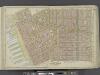
Manhattan, Double Page Plate No. 4 [Map bounded by Spring St., Broome St., Centre St., Pearl St., Thomas St., Jay St., Hudson River]
From Atlas of the city of New York, Manhattan Island. From actual surveys and official plans
[Map bounded by Pier - Line 40-51, Christopher Street, Greenwich Street, Desbrosses Street; Including West Street, Washington Street, Watts Street, Hoboken Ferry, Hoboken St, Canal Street, Spring Street, Charlton Street, King Street, Hamme
from Maps of the wharves and piers on the Hudson and East rivers from the Battery to 13th St., New York.
[Map bounded by Pier - Line 25-39, Vestry Street, Greenwich Street, Barcley Street; Including West Street, Washington Street, Robinson Street, Murray Street, Warren Street, Chambers Street, Reade Street, Duane Street, Jay Street, Harrison
from Maps of the wharves and piers on the Hudson and East rivers from the Battery to 13th St., New York.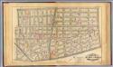
4. Wards 5-6, 8, 14.
1 : 2400 G.W. Bromley & Co.; Geo. W. Bromley & E. Robinson
Part of Section 2 : Plate 20.
from Atlas of the borough of Manhattan, city of New York.