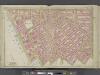
Maps of Hudson County

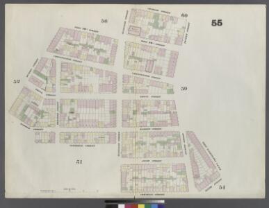
Plate 55: Map bounded by Charles Street, 4th Street, West Washington Place, Sixth Avenue, Cornelia Street, Bleeker Street, Commerce Street, Hudson Street, West 10th Street, Bleeker Street
from Maps of the city of New York.
[Plate 63: Map bounded by Amos Street, Charles Street, West 4th Street, West Washington Place, Sixth Avenue Cornelia Street, Bleecker Street, Carmine [Commerce] Street, Barrow Street, Hudson Street.]
from Maps of the city of New York / surveyed under directions of insurance companies of said city.
Manhattan, V. 3, Double Page Plate No. 55 [Map bounded by Hudson St., Perry St., W. 4th St., Cornelia St., Commerce St.]
From Atlas 42.53. Vol. 3, 1895.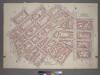
Plate 35, Part of Section 2: [Bounded by W. 11th Street, W. 4th Street, Perry Street, Waverly Place, Charles Street, Greenwich Avenue, Sixth Avenue, W. 8th Street, West Street, Macdougal Street, W. 3rd Street, Sixth Avenue, Cornelia Street, Bleecker Stre
from Atlas of the city of New York, borough of Manhattan. From actual surveys and official plans / by George W. and Walter S. Bromley.
Part of Section 2 : Plate 35.
from Atlas of the borough of Manhattan, city of New York.
Part of Section 2 : Plate 34.
from Atlas of the borough of Manhattan, city of New York.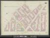
Manhattan, V. 3, Double Page Plate No. 59 [Map bounded by Bank St., W. 12th St., 6th Ave., W. 4th St., Perry St.]
From Atlas 42.53. Vol. 3, 1895.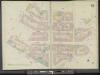
Manhattan, V. 3, Double Page Plate No. 51 [Map bounded by Commerce St., 6th Ave., Hancock St., W. Houston St., Hudson St.]
From Atlas 42.53. Vol. 3, 1895.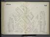
[Plate 67: Map bounded by West 4th Street, Perry Street, Seventh Avenue, West 12th Street, Sixth Avenue, West Washington Place.]
from Maps of the city of New York / surveyed under directions of insurance companies of said city.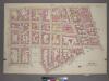
Plate 34, Part of Section 2: [Bounded by West Street, Charles Street, Hudson Street, Christopher Street, Bedford Street, Leroy Street, Varick Street and King Street.]
from Atlas of the city of New York, borough of Manhattan. From actual surveys and official plans / by George W. and Walter S. Bromley.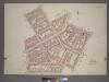
Plate 33, Part of Section 2: [Bounded by Barrow Street, Bleecker Street, W. Houston Street, Macdougal Street, King Street, Varick Street, Leroy Street and Bedford Street.]
from Atlas of the city of New York, borough of Manhattan. From actual surveys and official plans / by George W. and Walter S. Bromley.
[Plate 33: Bounded by Barrow Street, Bleecker Street, Cornelia Street, Sixth Avenue, W. 3rd Street, Sullivan Street, Bedford Street, Macdougal Street, King Street, Varick Street and Second Avenue Extension.]
from Atlas of the borough of Manhattan, city of New York.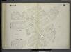
[Plate 59: Map bounded by Barrow Street, Commerce Street, Bleecker Street, Cornelia Street, Sixth Avenue, Hancock Street, Hamersly Street, Hudson Street.]
from Maps of the city of New York / surveyed under directions of insurance companies of said city.
Manhattan, V. 3, Double Page Plate [Map bounded by West St., Hudson River, 13th Ave.]
From Atlas 42.53. Vol. 3, 1895.
Plate 59: Map bounded by 12th Street, Sixth Avenue, West Washington Place, 4th Street, Perry Street, Greenwich Avenue, Seventh Avenue, 12th Street
from Maps of the city of New York.
Plate 51: Map bounded by Bleeker Street, Cornelia Street, Sixth Avenue, Carmine Street, Bleeker Street, Hancock Street, Hammersley Street, Hudson Street, Barrow Street, Commerce Street
from Maps of the city of New York.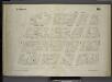
[Plate 64: Map bounded by Bank Street, Bleecker Street, Amos Street, West Street.]
from Maps of the city of New York / surveyed under directions of insurance companies of said city.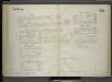
[Plate 62: Map bounded by West 9th Street, East 9th Street, University Place, East 4th Street, West 4th Street, Sixth Avenue.]
from Maps of the city of New York / surveyed under directions of insurance companies of said city.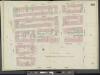
Manhattan, Double Page Plate No. 54 [Map bounded by E. 10th St., Wooster St., University Pl., W. 4th St., 6th Ave., W. 10th St.]
From Atlas 42.53. Vol. 3, 1895.
Plate 56: Map bounded by Bleeker Street, West 10th Street, West Street, Hammond Street, Hudson River, Bank Street
from Maps of the city of New York.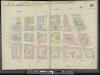
Manhattan, V. 3, Double Page Plate No. 52 [Map bounded by West St., W. 10th St., Hudson St., W. Houston St.]
From Atlas 42.53. Vol. 3, 1895.
Plate 52: Map bounded by West 10th Street, Hudson Street, Hammersley Street, West Street
from Maps of the city of New York.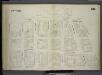
[Plate 60: Map bounded by West Street, Amos Street, Hudson Street, Hamersly Street.]
from Maps of the city of New York / surveyed under directions of insurance companies of said city.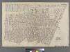
[Plate 10: Bounded by West Street (Hudson River, Piers 39-47), W. 11th Street, 13th Avenue (Hudson River, Piers [52?]-59), W. 14th Street, 7th Avenue, Greenwich Avenue, Perry Street, Waverly Place, Christopher Street, W. 4th Street, 6th Avenue, Bleecker
from Atlas of the city of New York : embracing all territory within its corporate limits from official records, private plans & actual surveys / by and under the supervision of E. Robinson & R.H. Pidgeon, civil engineers.
Plate 9: Bounded by Charles Street, Washington Street, W. 10th Street, Hudson Street, Christopher Street, Bedford Street, Barrow Street, Bleecker Street, Cornelia Street, Sixth Avenue, W. 3rd Street, W. Broadway, Broome Street, Hudson Street, Spring Stre
from Atlas of the city of New York, Manhattan Island. From actual surveys and official plans / by George W. and Walter S. Bromley.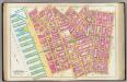
Pl. 9: wards 8-9 & 15.
1 : 1800 Bromley, George Washington; Bromley, Walter Scott
[Plate 10: Bounded by W. 14th Street, Sixth Avenue, Cornelia Street, Bleecker Street, Barrow Street, Bedford Street, Christopher Street, Hudson Street, W. 10th Street, Washington Street, Charles Street, West Street (Hudson River, ???), Gansevoort Street,
from Atlas of the city of New York, Manhattan Island. From actual surveys and official plans / by George W. and Walter S. Bromley.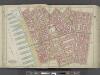
Manhattan, Double Page Plate No. 9 [Map bounded by Charles St., W. 3rd St., S. 5th Ave., Broome St., Hudson River]
From Atlas of the city of New York, Manhattan Island. From actual surveys and official plans
[Plate 9: Bounded by Charles Street, Washington Street, W. 10th Street, Hudson Street, Christopher Street, Bedford Street, Barrow Street, Bleecker Street, Cornelia Street, Sixth Avenue, W. 3rd Street, W. Broadway, Broome Street, Hudson Street, Spring Str
from Atlas of the city of New York, borough of Manhattan. From actual surveys and official plans / by George W. and Walter S. Bromley.