Maps of Kings County

Plate 30: Map bounded by Rivington Street, East Street, Water Street, Corlears Street, Grand Street, Cannon Street
from Maps of the city of New York.
[Plate 30: Map bounded by Cannon Street, Rivington Street, East Street, Cherry Street, Corlears Street, Grand Street; Including Lewis Street, Goerick Street, Mangin Street, Tompkins Street, Monroe Street, Broome Street, Delancy Street, Dela
from Maps of the city of New-York.
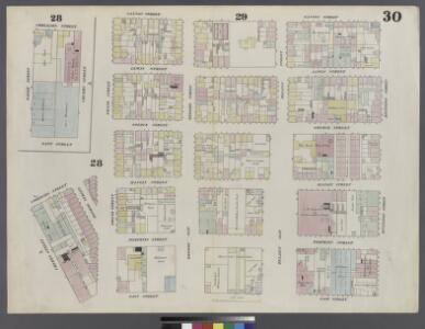
Manhattan, V. 1, Double Page Plate No. 30 [Map bounded by Cannon St., Rivington St., East St., Water St., Corlears St., Jackson St.]
From Atlas 107. Vol. 1, 1894.
Plate 19: Map bounded by Rivington Street, East Street, Grand Street, Columbia Street.
from Maps of the city of New York / surveyed under directions of insurance companies of said city.
Plate 18: Map bounded by Grand Street, East Street, Water Street, Corlears Street, South Street, Jackson Street.
from Maps of the city of New York / surveyed under directions of insurance companies of said city.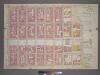
Plate 15, Part of Section 2: [Bounded by Stanton Street, Tompkins Street, Irvington Street, (East River Piers) East Street,Grand Street and Willett Street.]
from Atlas of the city of New York, borough of Manhattan. From actual surveys and official plans / by George W. and Walter S. Bromley.
Part of Section 2 : Plate 15.
from Atlas of the borough of Manhattan, city of New York.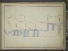
[Map bounded by Corlears St, Mangin St, Stanton St, Pier - Line 55-62, Cherry St; Including Tompkins St, East St, Grand St, Broome St, Delancy Slip, Rivington St]
from Maps of the wharves & piers from the Battery to 61st street on the Hudson river and from the Battery to 41st street on the East river, New York. Surveyed by I.C. Buckhout, city surveyor.
Manhattan, V. 1, Plate No. South piers B [Map of south piers B.]
From Atlas 107. Vol. 1, 1894.
Part of Section 1 : Plate 14.
from Atlas of the borough of Manhattan, city of New York.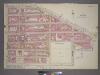
Plate 14, Part of Section 1: [Bounded by East Broadway, Grand Street, East Street, Water Street, Corlears Street, (East River) South Street and Montgomery Street.]
from Atlas of the city of New York, borough of Manhattan. From actual surveys and official plans / by George W. and Walter S. Bromley.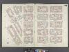
Manhattan, V. 1, Double Page Plate No. 29 [Map bounded by Ridge St., Rivington St., Cannon St., Jackson St., Madison St., Montgomery St.]
From Atlas 107. Vol. 1, 1894.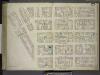
[Plate 29: Map bounded by Montgomery Street, Ridge Street, Rivington Street, Cannon Street, Henry Street; Including Gouverneur Street, Pitt Street, Scammel Street, Willet Street, Sheriff Street, Columbia Street, East Broadway, Division Str
from Maps of the city of New-York.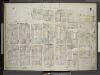
[Plate 31: Map bounded by East Houston Street, Avenue D, Third Street, Tompkins Street, Rivington Street, Willett Street; Including Stanton Street, Sheriff Street, Columbia Street, Manhattan Street, Cannon Street, Lewis Street, Goerck Street
from Insurance maps of the city of New York.
Plate 31: Map bounded by Houston Street, Avenue D, 3rd Street, East Street, Rivington Street, Willett Street
from Maps of the city of New York.
Plate 29: Map bounded by Rivington Street, Cannon Street, Henry Street, Montgomery Street, Ridge Street
from Maps of the city of New York.
Plate 39: Map bounded by Houston Street, Avenue D, 3rd Street, East River, Rivington Street, Willett Street.
from Maps of the city of New York / surveyed under directions of insurance companies of said city.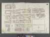
Manhattan, V. 1, Double Page Plate No. 28 [Map bounded by Grand St., Corlears St., South St., Montgomery St., Henry St.]
From Atlas 107. Vol. 1, 1894.
Manhattan, V. 1, Plate No. 82 [Map bounded by Rivington St., Cannon St., Grand St., Willett St.]
From Atlas 108. Vol. 1, [1903?].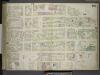
[Plate 28: Map bounded by Henry Street, Grand Street, Corlears Street, South Street, Montgomery Street; Including Madison Street, Monroe Street, Cherry Street, Water Street, Front Street, Gouverneur Street, Gouverneur Slip, Scammel Street, Ja
from Maps of the city of New-York.
Plate 28: Map bounded by Henry Street, Grand Street, Corlears Street, South Street, Montgomery Street
from Maps of the city of New York.
Manhattan, V. 2, Plate No. 7 [Map bounded by E. 3rd St., Goerck St., Rivington St., Columbia St.]
From Atlas 110. Vol. 2, 1903.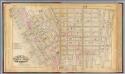
6. Wards 7, 11, 13.
1 : 2400 G.W. Bromley & Co.; Geo. W. Bromley & E. Robinson
Part of Sections 1 & 2 : New York City.
from Atlas of the city of New York, Manhattan Island. From actual surveys and official plans / by George W. and Walter S. Bromley.
[Plate 7: Bounded by E. 3rd Street, [East River, Piers 60-64] Tompkins Street, [East River, Piers 55-60] East Street, Water Street, Corlears Street, Grand Street, Attorney Street, Essex Street, and Avenue A.]
from Atlas of the city of New York, borough of Manhattan. From actual surveys and official plans / by George W. and Walter S. Bromley.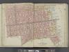
Manhattan, Double Page Plate No. 7 [Map bounded by E. 3rd St., East River, Grand St., Essex St.]
From Atlas of the city of New York, Manhattan Island. From actual surveys and official plans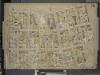
Brooklyn, Vol. 4, Double Page Plate No. 78; [Map bounded by Roebling St. late South St., South 3rd St., South 2nd St., South 1st St., Grand St., North 1st St.; Including North 2nd St., North 3rd St., North 4th St., North 5th St., North 6th St.,
from Insurance maps of the city of Brooklyn L.I.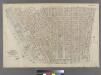
Part of Wards 7, 11 & 13, New York City.
from Atlas of the city of New York : embracing all territory within its corporate limits from official records, private plans & actual surveys / by and under the supervision of E. Robinson & R.H. Pidgeon, civil engineers.
Pl. 7: wards 7, 10-11, 13, 17.
1 : 1800 Bromley, George Washington; Bromley, Walter Scott