Maps of Dubrovacko-Neretvanska

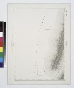
Babinopolje.
from Spezialkarte der osterreichisch-ungarischen Monarchie.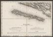
[Umgebung von Mljet]
Kroatien Dalmatien Mljet Umland
Dalmatien
1 : 80000 Dalmácie (Chorvatsko) Oesterreicher, T. Hydrographisches Amt der K. u. k. Kriegs-Marine, Seekarten-Depot
Neum und Stagno Grande.
from Spezialkarte der osterreichisch-ungarischen Monarchie.
Generalkarte von Bosnien und Herzegovina

Generalkarte von Bosnien und der Hercegovina
1 : 300000 Bosnien-Herzegowina Montenegro
Oestlicher Theil von Dalmatien
1 : 445000 Chorvatsko Santini, P. Engelman, J. W. F. A. Schraembl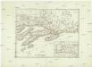
Oestlicher Theil von Dalmatien
1 : 450000 Chorvatsko Santini, P. Engelman, J. W. F. A. Schraembl
Generalkarte von Zentraleuropa

Adriatisches Meer, Küsten-Karte
1 : 180000 Jaderské moře (oblast) Oesterreicher, Tobias von Hydrographisches Amt der k. u. k. Kriegs-Marine
Hercegovina
1 : 400000 Hercegovina Daneš, Jiří Viktor Královská česká společnost nauk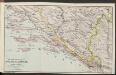
Die adriatische Küste von Spalato bis Cattaro
1 : 900000 Kroatien Adriaküste
Karte des Operations-Gebietes in Süd-Dalmatien (Crivoscie-Bocche di Cattaro) und der Herzegovina, nebst dem angrenzenden Fürstenthum Montenegro
1 : 325000 Dalmácie (Chorvatsko) A. Hartleben's Verlag
Mostar
1 : 200000 Mostar (Bosna a Hercegovina) Kartografska radionica
Partie de la Dalmatie du sud est avec l'Albanie
Albánie im Verlage des Kunst und Industrie Comptoirs
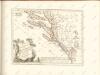
Le gouvernement de Raguse estant une partie de Dalmatie, avec quelques isles
1 : 310000 Dubrovník-oblast (Chorvatsko) Coronelli, Vincenzo Maria Schenk, Pieter apud Petrum Schenk Jun.
Railway-System in South-Dalmatia and in South-Eastern Herzegovina
Kroatien Dalmatien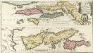
Le Gouvernement de Raguse
Mollova mapová sbírka Coronelli, Vincenzo Maria Schenk, Peter II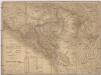
Karta Crnegore
1 : 285000 Albánie Karacsay, Fedor de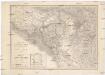
Karta Crnegore
1 : 285000 Albánie Karacsay, Fedor de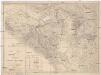
Karta Crnegore
1 : 285000 Albánie Karacsay, Fedor de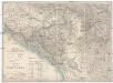
Karta Crnegore
1 : 285000 Albánie Karacsay, Fedor de
Dalmatien
1 : 80000 Dalmácie (Chorvatsko) Oesterreicher, T. Hydrographisches Amt der K. u. k. Kriegsmarine, Seekarten-Depot
Porto Rosso.
from Spezialkarte der osterreichisch-ungarischen Monarchie.
Ragusa.
from Spezialkarte der osterreichisch-ungarischen Monarchie.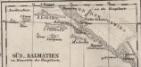
Süd-Dalmatien
Dalmatien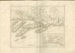

Eisenbahnkarte der k.u.k. oesterreichisch-ungarischen Monarchie

Ragusa, Mostar
1 : 750000 Dubrovník (Chorvatsko : oblast) Nimmerfroh, J. K. u. k. Militärgeographisches Institut
Ragusa, Mostar
1 : 750000 Dubrovník (Chorvatsko : oblast) K. u. k. militär-geografisches Institut