Maps of Zala

Jablanica und Podklecani.
from Spezialkarte der osterreichisch-ungarischen Monarchie.
Mappa Comitatvs Soproniensis 1758
1 : 1250000 Mollova mapová sbírka Zeller, Sebastian
Umgebungen von Hainburg in Oesterreich, und Presburg in Ungarn
1 : 144000 Bratislava-oblast (Slovensko) Müller, A. Withalm, Andreas
Comitatus Castri Ferrei
1 : 110000 Maďarsko Kenedics, Joseph Mansfeld, Johann Ernst
Plan der Gegend zwischen Wien, Neustadt, Presburg und OEdenburg
1 : 243000 Bratislava-oblast (Slovensko) Streit, Friedrich Wilhelm Liechtenstern, Joseph Marx von im Verl. d. Geographishen Instituts
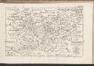
C. Soproniensis
Ungarn Komitat Ödenburg
C. Szaladiensis. Tab. II
Ungarn Komitat Zala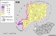
A szlovének arány és száma Vas megyében 1980-ban
Komitat Vas Slowenen, Siedlung Bottlik, Zsolt
Comitat Wieselburg
1 : 280000 Mosonmagyaróvár (Maďarsko)
Comitat Wieselburg
1 : 280000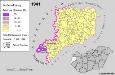
Slowenen im Komitat Vas 1941
Komitat Vas Slowenen, Siedlung Bottlik, Zsolt
C. Mosoniensis
Ungarn Komitat Moson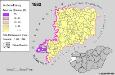
Slowenen im Komitat Vas 1880
Komitat Vas Slowenen, Siedlung Bottlik, Zsolt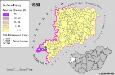
Slowenen im Komitat Vas 1980
Komitat Vas Slowenen, Siedlung Bottlik, Zsolt

Sopron vármegye
1 : 340000 Neziderské jezero (Maďarsko a Rakousko : oblast) Hegedüs, Johann Nepomuk Görög, Demeter Görög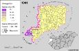
A szlovének arány és száma Vas megyében 1941-ben
Komitat Vas Slowenen, Siedlung Bottlik, Zsolt
Larpa Ceres spicas fragrantia vina ministrat Incopia Bachus, dat quo que terra Crocum
1 : 153333 Mollova mapová sbírka Vischer, Georg Matthaeus Hoffmann, Jakob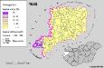
A szlovének arány és száma Vas megyében 1880-ban
Komitat Vas Slowenen, Siedlung Bottlik, Zsolt
Moson vármegye
1 : 130000 Neziderské jezero (Maďarsko a Rakousko : oblast) Kováts, János Görög, Demeter Görög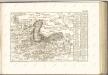
C. Castriferrei
Ungarn Komitat Vas
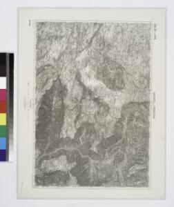
Steinamanger 161, uit: Special-Karte von Mittel-Europa / nach amtlichen Quellen bearbeitet von W. Liebenow
1 : 300000 titelvariant: W. Liebenow's Mittel-Europa; Annotatie: Titel boven de bladen: W. Liebenow's Mittel-Europa Johannes Wilhelm Liebenow 1822-1897 Frankfurt a. M. : Ludwig Ravenstein
Národnostní mapa Moravy
1 : 150000 Morava jižní (Česko) Chytil, Alois nákladem Al. Chytila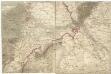
[Wien, Pressburg, Neusiedler See]
1 : 144000 Bratislava-oblast (Slovensko)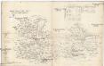
Oedenburger und Raaber Comitat
1 : 280000 Györ (Maďarsko : oblast)
Wienns umgebungen

Comitat Eisenburg
1 : 290000