Maps of Ljubovija Municipality

Vlasenica und Srebrenica.
from Spezialkarte der osterreichisch-ungarischen Monarchie.
Zvornik.
from Spezialkarte der osterreichisch-ungarischen Monarchie.
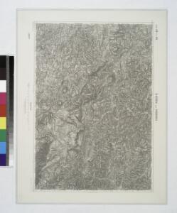
Rogatica.; Spezialkarte der osterreichisch-ungarischen Monarchie.
from Spezialkarte der osterreichisch-ungarischen Monarchie. Austro-Hungarian Monarchy. Militärgeographisches Institut.,
Treffen bei Senković Bandin (Odžiak) am 21. September 1878
1 : 50000 Bosna a Hercegovina Domansky, R. K.k. Generalstab
Treffen bei Senković Bandin (Odžiak)
1 : 50000 Bosnien-Herzegowina Gefecht Domansky, R.
Blatt XI, [Geologisch overzicht], uit: Geologische Übersichts-Karte der Österreichisch-Ungarischen Monarchie / nach den Aufnahmen der K.K. Geologischen Reichsanstalt bearb. von Franz Ritter von Hauer ; gezeichn. von Eduard Jahn
1 : 576000 Annotatie geografische gegevens: Gebaseerd op veldwerk in de jaren 1850 tot 1865 Hauer, Franz Ritter von; Jahn, Eduard; Kaiserlich-Königliche Geologische Reichsanstalt, Wenen Wien : Beck
[Generalkarte von Bosnien und der Hercegovina] K. 11. Bosna Seraj (Mostar)
1 : 300000 Bosnien-Herzegowina Herzegowina
Zvornik
1 : 200000 Zvornik (Bosna a Hercegovina : oblast) Kartografska radionica
Sarajevo.
Sarajevo (Bosna a Hercegovina) Blumtritt, H. Oesfeld, C. W. K. k. militär. geografisches Institut
Carte der Besitznehmung von Lesenitza, Lipanitza, Losenitza gegen Zwornick und Zokol von den K.K. Tr
1 Karte : Kupferdruck ; 12 x 17 cm [Trattner]
Kladanj und Cevljanovic.
from Spezialkarte der osterreichisch-ungarischen Monarchie.
Fakovic.
from Spezialkarte der osterreichisch-ungarischen Monarchie.
Zabukvica.
from Spezialkarte der osterreichisch-ungarischen Monarchie.
Vermehrte und Verbesserte Landkarten des Königreichs Ungarn :
1 : 500000 Mollova mapová sbírka Stier, Martin Böner, Johann-Alexander Endter, Martin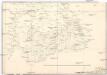
Strassen-Carte der Slawon. Militär-Gränze o. I. u. O
1 : 430000 Srbsko
Reg. Bosniae
1 : 875000 Mollova mapová sbírka Bruggen, Johann van der Brugge, Johannes van der
Reg. Bosniae
1 : 875000 Mollova mapová sbírka Pfeffel, Johann Andreas Pfeffel, Johann Andreas I.
Knjažestvo Srbije
1 : 493000 Srbsko Milenkovie, Iovan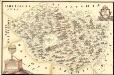
Mapa Particvlaris Regni Bosniae
Mollova mapová sbírka Geyer
Das Königreich Bosnia
1 : 1570000 Bosna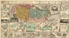
Regnum Bosniae, una cum finitimis Croatiae, Dalmatiae, Slavoniae, Hung. et Serviae partibus praecipuorum in his regionibus munimentorum ichnographia Curantibus
1 : 840000 Mollova mapová sbírka Ötinger, Johann Homann, Johann Baptista - dědici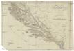
Oestreichisch Dalmatien und Albanien
1 : 930000 Albánie Mollo, Tranquillo Tranquillo Mollo
Oestreichisch Dalmatien und Albanien
1 : 930000 Albánie Mollo, Tranquillo Tranquillo Mollo
Bosnia & Hercegovina
Bosna a Hercegovina Jordán, J. P. J.P. Jordán
Sclavonia Croatia Bosnia cum Dalmatiae Parte
1 : 930000 Mollova mapová sbírka Mercator, Gerhard Mercator, Gerard
Republik Bosnien-Herzegowina. Katasterkarte: Bosniaken-Muslime
Bosnien-Herzegowina Bosnier, Grundeigentum
Herzegovina, Montenégro, Albanie Superieure
Nouvel atlas physique politique et historique de l'Empire ottoman et des états limitrophes en Europe, en Asie et en Afrique, en quarante feuilles Hellert, J.J. Bellizard, Dufour et Cie
Republik Bosnien-Herzegowina. Katasterkarte: Kroaten
Bosnien-Herzegowina Kroaten, Grundeigentum
Republik Bosnien-Herzegowina. Katasterkarte: Serben
Bosnien-Herzegowina Serben, Grundeigentum