Maps of Caras-Severin

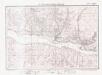
Weisskirchen und Szaszkabanya.
from Spezialkarte der osterreichisch-ungarischen Monarchie.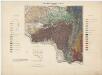
Zone 26, 27, Kol. XXV, Fehértemplom, Szászkabánya und Ómoldova, uit: [Geologische Specialkarte der im Reichsrathe vertretenen Königreiche und Länder der österreichisch-ungarischen Monarchie] / geologische Aufnahmen der königl. ung. Geologischen Anstalt
1 : 75000 Annotatie: Verantwoordelijkheidsvermelding in 1909 veranderd in: Königliche Ungarische Geologische Reichsanstalt; Sommige bladen in het Frans; Annotatie geografische gegevens: Coördinaten gebaseerd op nulmeridiaan van Ferro (Hierro) Königliche Ungarische Geologische Reichsanstalt; Königliche Ungarische Geologische Anstalt Budapest : [Königliche Ungarische Geologische Anstalt]
Weisskirchen und Szászkabánya
1 : 75000 Bela Crkva, Sasca Montanǎ Geripp: Fwkr. Suchánek u. Gfrtr. Tuschell. Terrain: Lieut. Hentke u. Oberlt. Zothe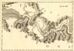
Costalaz - Jetz
Mollova mapová sbírka Marsili, Luigi Ferdinando
Carte der Zugrundrichtung der türk. Tscheiken des Lagers bei Borecz den 16. Sept. 1789
1 Karte : Kupferdruck ; 12 x 17 cm [Trattner]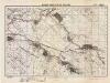
Lambert-Cholesky sheet 1850 (Berlistye)
1 : 20000 Romanian military topographic map sheet under Lambert-Cholensky projection Direcția Topografică Militară geo-spatial.org Direcția Topografică Militară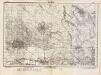
Lambert-Cholesky sheet 1849 (Bela Crkva)
1 : 20000 Romanian military topographic map sheet under Lambert-Cholensky projection Direcția Topografică Militară geo-spatial.org Direcția Topografică Militară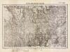
Lambert-Cholesky sheet 1848 (Neramezo)
1 : 20000 Romanian military topographic map sheet under Lambert-Cholensky projection Direcția Topografică Militară geo-spatial.org Direcția Topografică Militară
Lambert-Cholesky sheet 1847 (Vk. Gradiste)
1 : 20000 Romanian military topographic map sheet under Lambert-Cholensky projection Direcția Topografică Militară geo-spatial.org Direcția Topografică Militară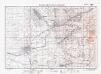
Lambert-Cholesky sheet 1950 (Oravita)
1 : 20000 Romanian military topographic map sheet under Lambert-Cholensky projection Direcția Topografică Militară geo-spatial.org Direcția Topografică Militară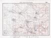
Lambert-Cholesky sheet 1949 (Petrilova)
1 : 20000 Romanian military topographic map sheet under Lambert-Cholensky projection Direcția Topografică Militară geo-spatial.org Direcția Topografică Militară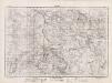
Lambert-Cholesky sheet 1948 (Stinapari)
1 : 20000 Romanian military topographic map sheet under Lambert-Cholensky projection Direcția Topografică Militară geo-spatial.org Direcția Topografică Militară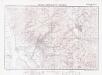
Lambert-Cholesky sheet 1947 (Moldova Veche)
1 : 20000 Romanian military topographic map sheet under Lambert-Cholensky projection Institutul Geografic Militar geo-spatial.org Institutul Geografic Militar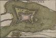
Vipalanka
Banatska Palanka Befestigung
Lambert-Cholesky sheet 1747 (Klicevac)
1 : 20000 Romanian military topographic map sheet under Lambert-Cholensky projection Institutul Geografic al Armatei geo-spatial.org Institutul Geografic al Armatei
Lambert-Cholesky sheet 1748 (Socol)
1 : 20000 Romanian military topographic map sheet under Lambert-Cholensky projection Serviciul Geografic al Armatei geo-spatial.org Serviciul Geografic al Armatei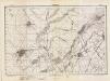
Lambert-Cholesky sheet 1750 (Voivodinci)
1 : 20000 Romanian military topographic map sheet under Lambert-Cholensky projection Direcția Topografică Militară geo-spatial.org Direcția Topografică Militară
Lambert-Cholesky sheet 2050 (Grohanul Mare)
1 : 20000 Romanian military topographic map sheet under Lambert-Cholensky projection Direcția Topografică Militară geo-spatial.org Direcția Topografică Militară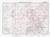
Lambert-Cholesky sheet 2049 (Lăpuşnicul Mare)
1 : 20000 Romanian military topographic map sheet under Lambert-Cholensky projection Direcția Topografică Militară geo-spatial.org Direcția Topografică Militară
Lambert-Cholesky sheet 2048 (Şopotu Nou)
1 : 20000 Romanian military topographic map sheet under Lambert-Cholensky projection Direcția Topografică Militară geo-spatial.org Direcția Topografică Militară
Lambert-Cholesky sheet 2047 (Gârnic)
1 : 20000 Romanian military topographic map sheet under Lambert-Cholensky projection Direcția Topografică Militară geo-spatial.org Direcția Topografică Militară
Alt-Moldova.
from Spezialkarte der osterreichisch-ungarischen Monarchie.
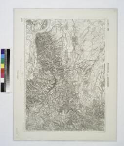
Temes-Kutas und D.-Oravica.
from Spezialkarte der osterreichisch-ungarischen Monarchie.
Alt-Moldova
1 : 75000 Moldova-Nouă Gemeindegebiet Geripp: Offic. W. Ahl. Terrain: Oberlt. K. Schwarz
Kostolac Viminacivm
1 : 6500 Kostolac (Srbsko) Papáček, Pavel Florinskij, Timofej Dmitrijevič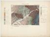
Zone 25, Kol. XXV, Temeskutas und Oraviczabánya, uit: [Geologische Specialkarte der im Reichsrathe vertretenen Königreiche und Länder der österreichisch-ungarischen Monarchie] / geologische Aufnahmen der königl. ung. Geologischen Anstalt
1 : 75000 Annotatie: Verantwoordelijkheidsvermelding in 1909 veranderd in: Königliche Ungarische Geologische Reichsanstalt; Sommige bladen in het Frans; Annotatie geografische gegevens: Coördinaten gebaseerd op nulmeridiaan van Ferro (Hierro) Königliche Ungarische Geologische Reichsanstalt; Königliche Ungarische Geologische Anstalt Budapest : [Königliche Ungarische Geologische Anstalt]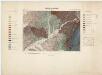
Temes-Kutas und D.-Oravica
1 : 75000 Gudurica, Oravita Schrift u. Gerippe v. Assistent Holl. Terrainschraffirung von Offizial Pflügl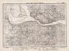
Lambert-Cholesky sheet 1946 (Coronini)
1 : 20000 Romanian military topographic map sheet under Lambert-Cholensky projection Direcția Topografică Militară geo-spatial.org Direcția Topografică Militară