Maps of Vukovarsko-Srijemska

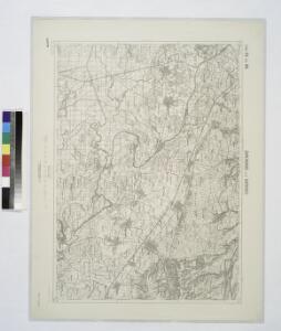
Sarengrad und Batrovci.
from Spezialkarte der osterreichisch-ungarischen Monarchie.
Šarengrad und Batrovci
1 : 75000 Šid, Bezirk Vukovar-Sirmien, Gemeindegebiet Geripp: Feldw. Niessner. Terrain: Adolf Hertel
Vukovar.
from Spezialkarte der osterreichisch-ungarischen Monarchie.
Jamena und Bijeljina.
from Spezialkarte der osterreichisch-ungarischen Monarchie.
Jamena und Bijeljina
1 : 75000 Bijeljina, Šid, Gemeindegebiet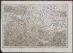
[Generalkarte von Bosnien und der Hercegovina] K. 10. (Brod)
1 : 300000 Bosnien-Herzegowina Bosnien
C. Bacsiensis
Ungarn Komitat Bács-Bodrog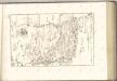

Mitrovica
1 : 200000 Sremska Mitrovica (Srbsko) Kartografska radionica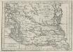
Charte von dem Kanal Franz des zweiten: Nach M. Votésky's Reduction von Ant. Quits Charte der Bácser Gespanschaft
1 : 510000 Landes-Industrie-Comptoir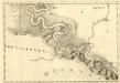
Vrangos - Palancka
Mollova mapová sbírka Marsili, Luigi Ferdinando
Ilok und Ruma.
from Spezialkarte der osterreichisch-ungarischen Monarchie.
Vukovar
1 : 75000 Vukovar Geripp: Fwkr. J. Suchánek. Terrain: Wachtmstr. Rud. v. Palitschek
Forst-Karte des Broder Regiments Bezirkes
Slavonski Brod (Chorvatsko : oblast) Spillauer, Fr.
Gradiste und Bos. Samac.; Spezialkarte der osterreichisch-ungarischen Monarchie.
from Spezialkarte der osterreichisch-ungarischen Monarchie. Austro-Hungarian Monarchy. Militärgeographisches Institut.,
Gradište und Bos. Šamac
1 : 75000 Bosanski Šamac, Bezirk Vukovar-Sirmien Geripp: Feldw. Watterich. Terrain: Oberlt. Mušic
Plan der Bergwerg fekete Patak und Berznye
Mollova mapová sbírka Geyer
Mitrowitz.
from Spezialkarte der osterreichisch-ungarischen Monarchie.
Ilok und Ruma
1 : 75000 Ilok, Ruma Geripp: J. Fitz. Terrain: Oblt. Karl Radler
Skizze der Gegend südlich u. westlich von Brčka
1 : 25000 Bosnien-Herzegowina Brčko Umland Ziegler, v.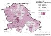
Vojvodina 1981. Jugoslawen (Jugosloveni)
Wojwodina ethnische Gruppe, Jugoslawen Hofinger, Veronika
Tabula Geographica Nova Et Exacta Distincte Exhibens Regnum Sclavoniae Cum Syrmii Ducatu Quod A Fluvus Savi Illovae Dravi Et Danubii Allitur Eius Provinitiae Conterminae Sunt Regnum Hungariae Croatiae Bosniae Serviae Et Bannatus Temesvrensis
Sirmien, Bosnien, Požarevac / Friede Khevenhüller-Frankenburg, Ludwig Andreas von, http://d-nb.info/gnd/116153849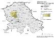
Vojvodina 1981. Montenegriner (Crnogorci)
Wojwodina ethnische Gruppe, Montenegriner Hofinger, Veronika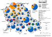
Vojvodina 1981. Nationalitäten
Wojwodina ethnische Gruppe Hofinger, Veronika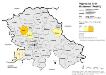
Vojvodina 1981. Ruthenen (Rusini)
Wojwodina ethnische Gruppe, Russinen Hofinger, Veronika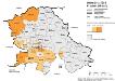
Vojvodina 1981. Kroaten (Hrvati)
Wojwodina ethnische Gruppe, Kroaten Hofinger, Veronika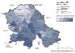
Vojvodina 1981. Serben (Srbi)
Wojwodina ethnische Gruppe, Serben Hofinger, Veronika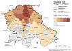
Vojvodina 1981. Magyaren (Madjari)
Wojwodina ethnische Gruppe, Magyaren Hofinger, Veronika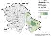
Vojvodina 1981. Rumänen (Rumuni)
Wojwodina ethnische Gruppe, Rumänen Hofinger, Veronika