Maps of Sibiu

Felek [Freck].
from Spezialkarte der osterreichisch-ungarischen Monarchie.
Felek (Freck)
1 : 75000 Avrig Geripp: Feldw. O. Tuschell. Terrain: Oblt. L. Mayr u. Offiz. J. Fitz
Lambert-Cholesky sheet 3558 (Drăguș)
1 : 20000 Romanian military topographic map sheet under Lambert-Cholensky projection Institutul Geografic Militar geo-spatial.org Institutul Geografic Militar
Lambert-Cholesky sheet 3557 (Muntele Drăgușului)
1 : 20000 Romanian military topographic map sheet under Lambert-Cholensky projection Institutul Geografic Militar geo-spatial.org Institutul Geografic Militar
Lambert-Cholesky sheet 3556 ()
1 : 20000 Romanian military topographic map sheet under Lambert-Cholensky projection Institutul Geografic Militar geo-spatial.org Institutul Geografic Militar
Lambert-Cholesky sheet 3458 (Porumbacul de Jos)
1 : 20000 Romanian military topographic map sheet under Lambert-Cholensky projection Direcția Topografică Militară geo-spatial.org Direcția Topografică Militară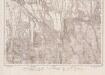
Lambert-Cholesky sheet 3457 (Porumbacul de Sus)
1 : 20000 Romanian military topographic map sheet under Lambert-Cholensky projection Institutul Geografic Militar geo-spatial.org Institutul Geografic Militar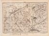
Lambert-Cholesky sheet 3358 (Avrig)
1 : 20000 Romanian military topographic map sheet under Lambert-Cholensky projection Direcția Topografică Militară geo-spatial.org Direcția Topografică Militară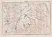
Lambert-Cholesky sheet 3357 (Racoviţa)
1 : 20000 Romanian military topographic map sheet under Lambert-Cholensky projection Direcția Topografică Militară geo-spatial.org Direcția Topografică Militară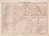
Lambert-Cholesky sheet 3356 (Vâraful Păului)
1 : 20000 Romanian military topographic map sheet under Lambert-Cholensky projection Direcția Topografică Militară geo-spatial.org Direcția Topografică Militară
Maršrut ot Rotenturmskago Karantina do s. Kineni
1 : 18000 Fagarašské hory (Rumunsko) Beketov, V.
Ujegyhaz [Leschkirch].
from Spezialkarte der osterreichisch-ungarischen Monarchie.
Verestorony [Rothenthurm-Pasz].
from Spezialkarte der osterreichisch-ungarischen Monarchie.
Situations Plan von dem Rothenthurner Pasz oder sogennanten Carolinschen Weege
Sibiu-oblast (Rumunsko) Fáborský, Jan B. Nipočić, Vasilij
Ujegyház
1 : 75000 Sibiu (Judeţ)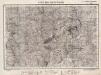
Lambert-Cholesky sheet 3655 (Muntele Bătrâna)
1 : 20000 Romanian military topographic map sheet under Lambert-Cholensky projection Direcția Topografică Militară geo-spatial.org Direcția Topografică Militară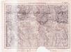
Lambert-Cholesky sheet 3656 (Muntele Ludişorului)
1 : 20000 Romanian military topographic map sheet under Lambert-Cholensky projection Institutul Geografic al Armatei geo-spatial.org Institutul Geografic al Armatei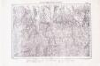
Lambert-Cholesky sheet 3657 (Breaza)
1 : 20000 Romanian military topographic map sheet under Lambert-Cholensky projection Institutul Geografic Militar geo-spatial.org Institutul Geografic Militar
Lambert-Cholesky sheet 3658 (Lisa)
1 : 20000 Romanian military topographic map sheet under Lambert-Cholensky projection Direcția Topografică Militară geo-spatial.org Direcția Topografică Militară
Gebiet um Hermannstadt
1 : 600000 Hermannstadt, Hermannstadt (Region)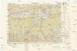
Osteuropa 1:300 000
1 : 300000 Brašov-oblast (Rumunsko) OKH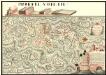
Plan der Batalie bei Beroschan in der Walachai samt den Drei Mahlichen Stvrm den 26. Jvli 1739
Mollova mapová sbírka Geyer
Harta Cailor de Comunicatie din Judetul Argesu
Rumänien Judeţ Argeş Verkehrsweg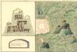
Plan des Bergwergs Saros Pataka
Mollova mapová sbírka Geyer
Lisza und Zernest.
from Spezialkarte der osterreichisch-ungarischen Monarchie.
Harta Cailor de Comunicatie din Judetul Muscel
Rumänien Muşcel
Verestorony (Rothenthurm - Pasz)
1 : 75000 Südkarpaten Pass
Calinesci.
from Spezialkarte der osterreichisch-ungarischen Monarchie.
Nagyszeben [Hermannstadt].
from Spezialkarte der osterreichisch-ungarischen Monarchie.
![Felek [Freck].](https://images-2.georeferencer.com/images/iiif/167819495660/full/,300/0/native.jpg)

