Maps of Péterhida

Belovar und Grdjevac Veliki.
from Spezialkarte der osterreichisch-ungarischen Monarchie.
Belovar
1 : 200000 Bjelovar (Chorvatsko : oblast) Kartografska radionica
Daruvar.; Spezialkarte der osterreichisch-ungarischen Monarchie.
from Spezialkarte der osterreichisch-ungarischen Monarchie. Austro-Hungarian Monarchy. Militärgeographisches Institut.,
Daruvar
1 : 75000 Daruvar
Siedlungsgebiet der Deutschen nach dem Nachbarschaftsindex für Süd-Transdanubien 1941
Ungarn (Süd) Deutsche, Siedlung Bottlik, Zsolt
A németek településterülete a szomszédsági mutató alapján Dél-Dunántúlon 1941-ban
Ungarn (Süd) Deutsche, Siedlung Bottlik, Zsolt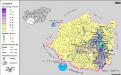
A németek településterülete a szomszédsági mutató alapján Dél-Dunántúlon 1880-ban
Ungarn (Süd) Deutsche, Siedlung Bottlik, Zsolt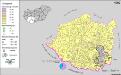
A németek településterülete a szomszédsági mutató alapján Dél-Dunántúlon 1980-ban
Ungarn (Süd) Deutsche, Siedlung Bottlik, Zsolt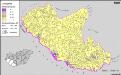
A horvátok aránya és száma Délnyugat-Magyarországon 1880-ben
Transdanubien (Süd) Kroaten, Siedlung Bottlik, Zsolt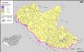
A horvátok aránya és száma Délnyugat-Magyarországon 1941-ben
Transdanubien (Süd) Kroaten, Siedlung Bottlik, Zsolt
A horvátok aránya és száma Délnyugat-Magyarországon 1980-ben
Transdanubien (Süd) Kroaten, Siedlung Bottlik, Zsolt
Siedlungsgebiet der Deutschen nach dem Nachbarschaftsindex für Süd-Transdanubien 1980
Ungarn (Süd) Deutsche, Siedlung Bottlik, Zsolt
Kroaten in Südwest-Ungarn 1980
Transdanubien (Süd) Kroaten, Siedlung Bottlik, Zsolt
Kroaten in Südwest-Ungarn 1880
Transdanubien (Süd) Kroaten, Siedlung Bottlik, Zsolt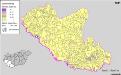
Kroaten in Südwest-Ungarn 1941
Transdanubien (Süd) Kroaten, Siedlung Bottlik, Zsolt
Istria olim Lapidia
1 : 250000 Mollova mapová sbírka Blaeu, Willem Janszoon Schenk, Peter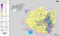
Siedlungsgebiet der Deutschen nach dem Nachbarschaftsindex für Süd-Transdanubien 1880
Ungarn (Süd) Deutsche, Siedlung Bottlik, Zsolt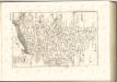

C. Sümeghiensis
Ungarn Komitat Somogy
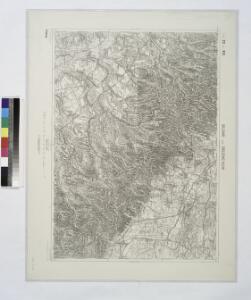
Dubrava und Gradec.
from Spezialkarte der osterreichisch-ungarischen Monarchie.
Berzence
1 : 75000 Berzence
Berzence und St. Georgen.; Spezialkarte der osterreichisch-ungarischen Monarchie.
from Spezialkarte der osterreichisch-ungarischen Monarchie. Austro-Hungarian Monarchy. Militärgeographisches Institut.,
Barcs
1 : 75000 Barcs
Barcs und Virovitica.; Spezialkarte der osterreichisch-ungarischen Monarchie.
from Spezialkarte der osterreichisch-ungarischen Monarchie. Austro-Hungarian Monarchy. Militärgeographisches Institut.,
Nagy-Atad und Szigetvar.
from Spezialkarte der osterreichisch-ungarischen Monarchie.
Dubrava
1 : 75000 Zagreb
Ivanic Klostar und Moslavina.
from Spezialkarte der osterreichisch-ungarischen Monarchie.
Slatina und Vocin.; Spezialkarte der osterreichisch-ungarischen Monarchie.
from Spezialkarte der osterreichisch-ungarischen Monarchie. Austro-Hungarian Monarchy. Militärgeographisches Institut.,
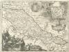
Tabula Geographica Nova Et Exacta Distincte Exhibens Regnum Sclavoniae Cum Syrmii Ducatu Quod A Fluvus Savi Illovae Dravi Et Danubii Allitur Eius Provinitiae Conterminae Sunt Regnum Hungariae Croatiae Bosniae Serviae Et Bannatus Temesvrensis
Sirmien, Bosnien, Požarevac / Friede Khevenhüller-Frankenburg, Ludwig Andreas von, http://d-nb.info/gnd/116153849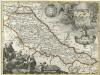
Regnum Slavoniae
1 : 1100000 Mollova mapová sbírka Bruggen, Johann van der Brugge, Johannes van der